Chicago/waukegan - Waukegan Regl
Airport details
| Country | United States of America |
| State | Illinois |
| Region | K5 |
| Airspace | Chicago Ctr |
| Municipality | Waukegan |
| Elevation | 727ft (222m) |
| Timezone | GMT -6 |
| Coordinates | 42.42210, -87.86174 |
| Magnetic var | |
| Type | land |
| Available since | X-Plane v10.40 |
| ICAO code | KUGN |
| IATA code | UGN |
| FAA code | UGN |
Communication
| Waukegan Regl ATIS | 132.400 |
| Waukegan Regl CTAF | 120.050 |
| Waukegan Regl UNICOM | 122.950 |
| Waukegan Regl Ground Control | 121.650 |
| Waukegan Regl Tower | 120.050 |
| Waukegan Regl CHICAGO Approach/Departure | 120.550 |
Approach frequencies
| ILS-cat-I | RW23 | 110.7 | 18.00mi |
| 3° GS | RW23 | 110.7 | 18.00mi |
Nearby Points of Interest:
Zion Chapter House
-Near North Historic District
-Camp Logan
-Waukegan Public Library
-Waukegan Building
-Hotel Waukegan
-Henry I. Paddock House
-Holy Family Church
-Chiwaukee Prairie
-Dewey House
-Lester Armour House
-William McCormick Blair Estate
-Mrs. Isaac D. Adler House
-John Griffith Store Building
-Lake Bluff Uptown Commercial Historic District
-Southport Beach House
-Public Service Building
-Mrs. C. Morse Ely House
-Manor House
-Anthony and Caroline Isermann House
-Frank and Jane Isermann House
-Third Avenue Historic District
-Kemper Hall
-Wisconsin
-Ragdale
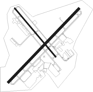
Runway info
Runway 5 / 23  | ||
| length | 1827m (5994ft) | |
| bearing | 57° / 237° | |
| width | 46m (150ft) | |
| surface | asphalt | |
| Runway 14 / 32 | ||
| length | 1143m (3750ft) | |
| bearing | 136° / 316° | |
| width | 23m (75ft) | |
| surface | asphalt | |
| displ threshold | 152m (499ft) / 0m (0ft) | |
Nearby beacons
| code | identifier | dist | bearing | frequency |
|---|---|---|---|---|
| UG | WAUKE (CHICAGO/WAUKEGAN) NDB | 3.6 | 55° | 379 |
| ENW | DME | 11 | 338° | 109.20 |
| OBK | NORTHBROOK VOR/DME | 12.6 | 204° | 113 |
| RA | PASER (RACINE) NDB | 15.7 | 352° | 206 |
| HRK | (RACINE) DME | 20.5 | 8° | 117.70 |
| BUU | (BURLINGTON) DME | 25.2 | 301° | 114.50 |
| GCO | DME | 25.7 | 185° | 108.25 |
| DPA | DUPAGE (CHICAGO) VOR/DME | 38.6 | 223° | 108.40 |
| MX | KEDZI (CHICAGO) NDB | 41.5 | 166° | 248 |
| LJT | (MILWAUKEE) DME | 42 | 346° | 115.65 |
| BAE | BADGER (MILWAUKEE) VOR/DME | 45.6 | 329° | 116.40 |
| CGT | CHICAGO HEIGHTS VORTAC | 56.2 | 162° | 114.20 |
| GY | GARIE (GARY) NDB | 56.3 | 148° | 236 |
| JOT | JOLIET VOR/DME | 56.4 | 208° | 112.30 |
| RYV | ROCK RIVER (WATERTOWN) NDB | 59 | 311° | 371 |
| BJB | WEST BEND VOR | 61.1 | 345° | 109.80 |
| VP | SEDLY (VALPARAISO) NDB | 73 | 135° | 212 |
Departure and arrival routes
| Transition altitude | 18000ft |
| Transition level | 18000ft |
| SID end points | distance | outbound heading | |
|---|---|---|---|
| RW05 | |||
| MONKZ5 | 201mi | 163° | |
| JORJO5 | 111mi | 189° | |
| RW14 | |||
| MONKZ5 | 201mi | 163° | |
| JORJO5 | 111mi | 189° | |
| RW23 | |||
| MONKZ5 | 201mi | 163° | |
| JORJO5 | 111mi | 189° | |
| RW32 | |||
| MONKZ5 | 201mi | 163° | |
| JORJO5 | 111mi | 189° | |
| STAR starting points | distance | inbound heading | |
|---|---|---|---|
| ALL | |||
| GOPAC2 | 34.0 | 125° | |
Instrument approach procedures
| runway | airway (heading) | route (dist, bearing) |
|---|---|---|
| RW05 | FOVOJ (57°) | FOVOJ 2400ft |
| RW05 | JETRU (19°) | JETRU FOVOJ (8mi, 310°) 2400ft |
| RW05 | PLSNT (85°) | PLSNT FOVOJ (8mi, 130°) 2400ft |
| RNAV | FOVOJ 2400ft BILCO (6mi, 57°) 2400ft HIGEK (3mi, 57°) 1400ft KUGN (3mi, 59°) 766ft (5310mi, 116°) 976ft LIRIC (5303mi, 296°) 2300ft LIRIC (turn) | |
| RW23 | LIRIC (236°) | LIRIC 2300ft |
| RW23 | PAPPI (301°) | PAPPI FOLBU (12mi, 355°) 2300ft LIRIC (5mi, 310°) 2300ft |
| RW23 | TALOR (235°) | TALOR LIRIC (5mi, 232°) 2300ft |
| RNAV | LIRIC 2300ft OLBOE (6mi, 237°) 1900ft KUGN (4mi, 235°) 776ft (5310mi, 116°) 980ft FOVOJ (5319mi, 296°) 2400ft FOVOJ (turn) |
Holding patterns
| STAR name | hold at | type | turn | heading* | altitude | leg | speed limit |
|---|---|---|---|---|---|---|---|
| GOPAC2 | LEEDN | VHF | right | 181 (1)° | DME 10.0mi | ICAO rules | |
| GOPAC2 | ZOWRO | VHF | right | 273 (93)° | DME 10.0mi | ICAO rules | |
| *) magnetic outbound (inbound) holding course | |||||||
Disclaimer
The information on this website is not for real aviation. Use this data with the X-Plane flight simulator only! Data taken with kind consent from X-Plane 12 source code and data files. Content is subject to change without notice.