Vinton - Vinton Veterans Memorial Arpk
Airport details
| Country | United States of America |
| State | Iowa |
| Region | K3 |
| Airspace | Chicago Ctr |
| Municipality | Benton County |
| Elevation | 845ft (258m) |
| Timezone | GMT -6 |
| Coordinates | 42.21864, -92.02592 |
| Magnetic var | |
| Type | land |
| Available since | X-Plane v10.40 |
| ICAO code | KVTI |
| IATA code | n/a |
| FAA code | VTI |
Communication
| Vinton Veterans Memorial Arpk AWOS 3 | 120.075 |
| Vinton Veterans Memorial Arpk CTAF/UNICOM | 122.800 |
| Vinton Veterans Memorial Arpk CEDAR RAPIDS Approach/Departure | 134.050 |
Nearby Points of Interest:
Iowa Canning Company Seed House Building
-Benton County Courthouse
-Vinton Public Library
-Burlington, Cedar Rapids & Northern Passenger Station-Vinton
-Central Vinton Residential Historic District
-Clement B. Gingrich House
-Chapple and Young Block
-John N. and Mary McQuilken House
-Syndicate Block
-LaPorte City Town Hall and Fire Station
-La Porte City Station
-Dr. Jesse Wasson Building
-August H.J. and Justena Lange Farmstead Historic District
-280th Street Bridge
-Walker Station
-Taylor's Ford Bridge
-Youngville Cafe
-Wapsipinicon River Bridge
-State Savings Bank
-Odd Fellows Hall
-Cedar Rock State Park
-Robert R. and Julia L. Plane House
-Wapsipinicon Mill
-Fisher-Plane Commercial Building
-Lee House
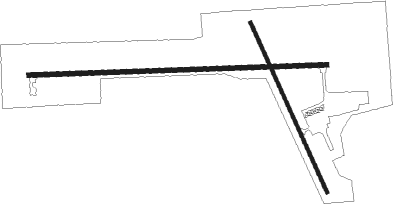
Runway info
Runway 9 / 27  | ||
| length | 1220m (4003ft) | |
| bearing | 92° / 272° | |
| width | 18m (60ft) | |
| surface | concrete | |
| Runway 16 / 34 | ||
| length | 763m (2503ft) | |
| bearing | 154° / 334° | |
| width | 15m (50ft) | |
| surface | asphalt | |
| displ threshold | 0m (0ft) / 63m (207ft) | |
Nearby beacons
| code | identifier | dist | bearing | frequency |
|---|---|---|---|---|
| IIB | WAPSIE (INDEPENDENCE) NDB | 14.4 | 18° | 206 |
| CID | CEDAR RAPIDS VOR/DME | 22.5 | 144° | 114.10 |
| ALO | WATERLOO VOR/DME | 26.1 | 312° | 112.20 |
| JWJ | ELMWOOD (MARSHALTOWN) VOR/DME | 39.8 | 263° | 109.40 |
| IOW | IOWA CITY VOR/DME | 45.8 | 149° | 116.20 |
| IY | CHUKK (CHARLES CITY) NDB | 63.1 | 323° | 417 |
| PEA | PELLA NDB | 63.8 | 228° | 257 |
| DDD | CITY DME | 64.5 | 134° | 116.50 |
Instrument approach procedures
| runway | airway (heading) | route (dist, bearing) |
|---|---|---|
| RW09 | LYERS (128°) | LYERS WUZMU (10mi, 192°) 3000ft |
| RW09 | VINTY (353°) | VINTY ADCOJ (11mi, 268°) 3500ft WUZMU (6mi, 350°) 3000ft |
| RW09 | WUZMU (92°) | WUZMU 3000ft |
| RNAV | WUZMU 3000ft IJIGU (6mi, 92°) 2500ft EHPEK (3mi, 92°) 1540ft KVTI (3mi, 92°) 869ft JOHUJ (11mi, 92°) 3000ft JOHUJ (turn) | |
| RW27 | CID (324°) | CID ZITPI (14mi, 2°) 3000ft JOHUJ (5mi, 4°) 3000ft |
| RW27 | INDET (206°) | INDET EJGUD (14mi, 152°) 4000ft JOHUJ (5mi, 184°) 3000ft |
| RW27 | JOHUJ (272°) | JOHUJ 3000ft |
| RNAV | JOHUJ 3000ft SIFOJ (6mi, 272°) 2500ft CULBE (3mi, 272°) 1440ft KVTI (2mi, 271°) 878ft WUZMU (12mi, 272°) 3000ft WUZMU (turn) |
Disclaimer
The information on this website is not for real aviation. Use this data with the X-Plane flight simulator only! Data taken with kind consent from X-Plane 12 source code and data files. Content is subject to change without notice.