Waynesburg - Greene Co
Airport details
| Country | United States of America |
| State | Pennsylvania |
| Region | K6 |
| Airspace | Cleveland Ctr |
| Municipality | Franklin Township |
| Elevation | 1063ft (324m) |
| Timezone | GMT -5 |
| Coordinates | 39.90114, -80.13069 |
| Magnetic var | |
| Type | land |
| Available since | X-Plane v10.40 |
| ICAO code | KWAY |
| IATA code | WAY |
| FAA code | WAY |
Communication
| Greene Co CTAF/UNICOM | 122.800 |
Nearby Points of Interest:
Greene Hills Farm
-Charles Grant Heasley House
-Bridge in Franklin Township
-Thomas Kent, Jr., Farm
-Hanna Hall
-Miller Hall
-Waynesburg Historic District
-George West Gordon Farm
-McClelland-Grimes Farm
-Grimes Covered Bridge
-John Rex Farm
-Hughes House
-William Cree House
-Hamilton-Ely Farmstead
-John Corbley Farm
-Rice's Landing Historic District
-Martin's Mill Covered Bridge
-White Covered Bridge
-Ulery Mill
-Greene Academy
-Horn Davis Overholtzer Bridge
-Marianna Historic District
-Shriver Covered Bridge
-Neils Red Covered Bridge
-William Crawford House
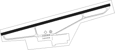
Runway info
| Runway 9 / 27 | ||
| length | 1060m (3478ft) | |
| bearing | 82° / 262° | |
| width | 23m (75ft) | |
| surface | asphalt | |
Nearby beacons
| code | identifier | dist | bearing | frequency |
|---|---|---|---|---|
| VV | CAMOR (CONNELLSVILLE) NDB | 17.8 | 93° | 299 |
| AGC | ALLEGHENY (PITTSBURGH) VOR/DME | 23 | 13° | 110 |
| MGW | MORGANTOWN VOR/DME | 24.1 | 142° | 111.60 |
| HLG | WHEELING VOR/DME | 29.4 | 309° | 112.20 |
| AIR | BELLAIRE VOR/DME | 32.3 | 280° | 117.10 |
| MMJ | (PITTSBURGH) DME | 35.3 | 354° | 112 |
| IHD | INDIAN HEAD VORTAC | 35.8 | 85° | 108.20 |
| CKB | CLARKSBURG VOR/DME | 39.4 | 192° | 112.60 |
| CFX | CADIZ NDB | 45.2 | 291° | 239 |
| EWC | ELLWOOD CITY VOR/DME | 55.6 | 355° | 115.80 |
| EKN | ELKINS VORTAC | 59.2 | 178° | 114.20 |
Instrument approach procedures
| runway | airway (heading) | route (dist, bearing) |
|---|---|---|
| RW09-Z | BURGS (66°) | BURGS ZUNKO (13mi, 50°) 4000ft |
| RW09-Z | ZUNKO (81°) | ZUNKO 4000ft |
| RNAV | ZUNKO 4000ft PUNIY (6mi, 81°) 3000ft WONAT (3mi, 81°) 1940ft KWAY (3mi, 81°) 1105ft (4951mi, 116°) 1469ft RIPEE (4940mi, 297°) 4000ft RIPEE (turn) 4000ft | |
| RW27 | GALLS (304°) | GALLS RIPEE (9mi, 52°) 4000ft RIPEE (turn) 4000ft |
| RNAV | RIPEE 4000ft TIKKU (6mi, 261°) 2900ft KWAY (6mi, 261°) 1112ft (4951mi, 116°) 1469ft ZUNKO (4963mi, 296°) 4000ft ZUNKO (turn) |
Disclaimer
The information on this website is not for real aviation. Use this data with the X-Plane flight simulator only! Data taken with kind consent from X-Plane 12 source code and data files. Content is subject to change without notice.