Winder - Winder Barrow
Airport details
| Country | United States of America |
| State | Georgia |
| Region | K7 |
| Airspace | Atlanta Ctr |
| Municipality | Barrow County |
| Elevation | 941ft (287m) |
| Timezone | GMT -5 |
| Coordinates | 33.98228, -83.66977 |
| Magnetic var | |
| Type | land |
| Available since | X-Plane v10.40 |
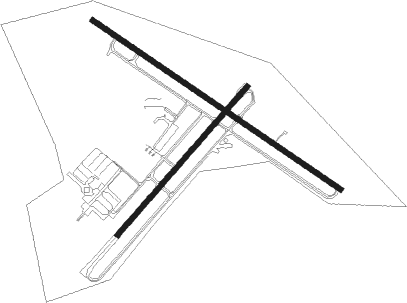
| ICAO code | KWDR |
| IATA code | WDR |
| FAA code | WDR |
Communication
| WINDER BARROW AWOS 3 | 118.575 |
| WINDER BARROW CTAF/UNICOM | 123.000 |
| WINDER BARROW ATLANTA Approach/Departure | 132.475 |
| WINDER BARROW ATLANTA Approach/Departure | 127.500 |
Approach frequencies
| ILS-cat-I | RW31 | 111.5 | 18.00mi |
| 3° GS | RW31 | 111.5 | 18.00mi |
Nearby Points of Interest:
Barrow County Courthouse
-William Harris Homestead
-Kilgore Mill Covered Bridge and Mill Site
-UGA Carnegie Library
-Cobbham Historic District
-Lucy Cobb Institute
-Henry W. Grady House
-Camak House
-Joseph Henry Lumpkin House
-Ware-Lyndon house
-Gospel Pilgrim Cemetery
-Gwinnett County Courthouse
-Old Seminary Building
-Bowman-Pirkle House
-John Quincy Allen House
-Elder's Mill Covered Bridge and Elder Mill
-Beulah Rucker House-School
-Hard Labor Creek State Park
-Old Hall County Courthouse
-Gainesville Commercial Historic District
-Federal Building and U.S. Courthouse
-Brick Store
-Orna Villa
-Oxford Historic District
-Superb

Nearby beacons
| code | identifier | dist | bearing | frequency |
|---|---|---|---|---|
| BMW | BARROW COUNTY (WINDER) NDB | 4.8 | 120° | 404 |
| TX | GWNET (LAWRENCEVILLE) NDB | 9.8 | 281° | 419 |
| AHN | ATHENS VOR/DME | 17.3 | 96° | 109.60 |
| FKV | FLOWERY BRANCH (GAINESVILLE) NDB | 17.7 | 313° | 365 |
| VOF | ALCOVY (COVINGTON) NDB | 21.9 | 198° | 370 |
| PDK | PEACHTREE (ATLANTA) VOR/DME | 31.9 | 260° | 116.60 |
| VV | JUNNE (GREENSBORO) NDB | 38.1 | 117° | 353 |
| DOB | DOBBINS (MARIETTA) TACAN | 41.9 | 265° | 113 |
| ATL | ATLANTA VORTAC | 43.6 | 245° | 116.90 |
| DJD | CHERO NDB | 43.7 | 288° | 415 |
| ODF | FOOTHILLS (TOCCOA) VOR/DME | 46.6 | 28° | 113.40 |
| AT | CATTA (ATLANTA) NDB | 47.9 | 249° | 375 |
| ELW | ELECTRIC CITY (ANDERSON) VORTAC | 51.1 | 64° | 108.60 |
| UMB | CULVR (MILLEDGEVILLE) NDB | 56 | 148° | 380 |
| FFC | PECAT (ATLANTA) NDB | 57.8 | 230° | 316 |
| HRS | HARRIS VORTAC | 58.9 | 346° | 109.80 |
Instrument approach procedures
| runway | airway (heading) | route (dist, bearing) |
|---|---|---|
| RW23 | AHN (276°) | AHN PATTE (13mi, 312°) 3000ft PATTE (turn) 3000ft |
| RW23 | IRMOS (224°) | IRMOS PATTE (7mi, 211°) 3000ft |
| RW23 | WOMAC (122°) | WOMAC PATTE (20mi, 92°) 3700ft PATTE (turn) 3000ft |
| RNAV | PATTE 3000ft ZEKMI (6mi, 231°) 2500ft KWDR (5mi, 232°) 956ft (5090mi, 112°) 1179ft HAWCU (5092mi, 292°) BGRED (6mi, 166°) JOTNO (16mi, 107°) 3000ft JOTNO (turn) | |
| RW31 | AHN (276°) | AHN CADEB (9mi, 241°) 3000ft |
| RW31 | CADEB (303°) | CADEB 3000ft |
| RW31 | JOTNO (309°) | JOTNO CADEB (8mi, 319°) 3000ft |
| RNAV | CADEB 3000ft BEYKA (7mi, 304°) 2500ft KWDR (5mi, 302°) 952ft (5090mi, 112°) 1172ft AXADE (5094mi, 292°) MATME (8mi, 44°) PATTE (7mi, 102°) 3000ft PATTE (turn) |
Disclaimer
The information on this website is not for real aviation. Use this data with the X-Plane flight simulator only! Data taken with kind consent from X-Plane 12 source code and data files. Content is subject to change without notice.