Wrightstown - Mcguire Afb
Airport details
| Country | United States of America |
| State | New Jersey |
| Region | K6 |
| Airspace | New York Ctr |
| Municipality | New Hanover Township |
| Elevation | 128ft (39m) |
| Timezone | GMT -5 |
| Coordinates | 40.01391, -74.60274 |
| Magnetic var | |
| Type | land |
| Available since | X-Plane v10.40 |
| ICAO code | KWRI |
| IATA code | WRI |
| FAA code | WRI |
Communication
| McGuire AFB ATIS | 110.600 |
| McGuire AFB Clearance DEL | 135.200 |
| McGuire AFB Ground Control | 121.800 |
| McGuire AFB Tower | 118.650 |
| McGuire AFB Approach/Departure | 124.150 |
Approach frequencies
| ILS-cat-II | RW06 | 110.1 | 18.00mi |
| ILS-cat-I | RW24 | 110.1 | 18.00mi |
| 3° GS | RW24 | 110.1 | 18.00mi |
| 3° GS | RW06 | 110.1 | 18.00mi |
Nearby Points of Interest:
Old Upper Springfield Friends Burying Ground
-Zurbrugg Mansion
-Arney's Mount Friends Meetinghouse and Burial Ground
-Morris Mansion and Mill
-Brainerd School
-Peachfield
-Providence Presbyterian Church of Bustleton
-Bordentown School
-Francis Hopkinson House
-Point Breeze
-Salter's Mill
-Abbott Farm Historic District
-Upper Freehold Baptist Meeting
-Kirby's Mill
-Isaac Watson House
-Jefferson Avenue School
-Harriman Historic District
-Bow Hill
-St. Mary's Episcopal Church, Burlington
-Fallsington Historic District
-Bristol Historic District
-Dorrance Mansion
-Burlington Historic District
-Revell House
-Clarksburg Methodist Episcopal Church
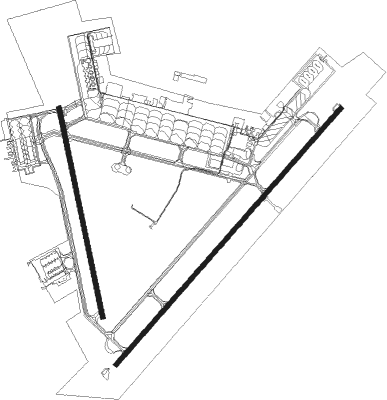
Runway info
Runway 6 / 24  | ||
| length | 3491m (11453ft) | |
| bearing | 53° / 233° | |
| width | 46m (150ft) | |
| surface | asphalt | |
| displ threshold | 140m (459ft) / 304m (997ft) | |
| blast zone | 169m (554ft) / 0m (0ft) | |
| Runway 18 / 36 | ||
| length | 2180m (7152ft) | |
| bearing | 171° / 351° | |
| width | 46m (150ft) | |
| surface | concrete | |
| blast zone | 18m (59ft) / 5m (16ft) | |
Nearby beacons
| code | identifier | dist | bearing | frequency |
|---|---|---|---|---|
| GXU | MC GUIRE (WRIGHTSTOWN) VORTAC | 0.3 | 125° | 110.60 |
| NEL | LAKEHURST TACAN | 11.5 | 85° | 111.80 |
| RBV | ROBBINSVILLE VORTAC | 12.3 | 30° | 113.80 |
| NEL | LAKEHURST NDB | 12.4 | 83° | 396 |
| CYN | COYLE VORTAC | 14.1 | 139° | 113.40 |
| ARD | YARDLEY VOR/DME | 20 | 308° | 108.20 |
| COL | COLTS NECK VOR/DME | 27 | 56° | 115.40 |
| ING | AMBLER NDB | 32 | 279° | 275 |
| VCN | CEDAR LAKE (MILLVILLE) VOR/DME | 33.1 | 217° | 115.20 |
| ACY | ATLANTIC CITY VORTAC | 33.5 | 177° | 108.60 |
| SBJ | SOLBERG VOR/DME | 34.7 | 346° | 112.90 |
| OOD | WOODSTOWN VORTAC | 39.4 | 242° | 112.80 |
| RNB | RAINBOW (MILLVILLE) NDB | 43.4 | 222° | 363 |
| CAT | CHATHAM NDB | 44.3 | 13° | 254 |
| PTW | POTTSTOWN VORTAC | 45.7 | 282° | 116.50 |
| BWZ | BROADWAY (SCHOOLEY'S MT) VOR/DME | 48.1 | 344° | 114.20 |
| CRI | CANARSIE VOR/DME | 48.4 | 50° | 112.30 |
| TE | TORBY (TETERBORO) NDB | 52.1 | 31° | 214 |
| JFK | KENNEDY (NEW YORK) VOR/DME | 53.2 | 53° | 115.90 |
| MM | MOREE (MORRISTOWN) NDB | 53.4 | 17° | 392 |
| TEB | TETERBORO VOR/DME | 55.8 | 33° | 108.40 |
| SIE | SEA ISLE VORTAC | 55.9 | 192° | 114.80 |
| LGA | LA GUARDIA (NEW YORK) VOR/DME | 57.1 | 44° | 113.10 |
| FJC | ALLENTOWN VORTAC | 57.8 | 310° | 117.50 |
| STW | STILLWATER VOR/DME | 60.2 | 345° | 109.60 |
| ENO | SMYRNA (KENTON) VORTAC | 63.1 | 229° | 111.40 |
| DOV | DOVER TACAN | 66.3 | 224° | 110 |
Departure and arrival routes
| Transition altitude | 18000ft |
| Transition level | 18000ft |
| SID end points | distance | outbound heading | |
|---|---|---|---|
| RW06 | |||
| PTPL5 | 100mi | 71° | |
| MXE4 | 155mi | 259° | |
| PTW3 | 97mi | 285° | |
| RW18 | |||
| PTPL5 | 100mi | 71° | |
| MXE4 | 155mi | 259° | |
| PTW3 | 97mi | 285° | |
| RW24 | |||
| PTPL5 | 100mi | 71° | |
| MXE4 | 155mi | 259° | |
| PTW3 | 97mi | 285° | |
| RW36 | |||
| PTPL5 | 100mi | 71° | |
| MXE4 | 155mi | 259° | |
| PTW3 | 97mi | 285° | |
| STAR starting points | distance | inbound heading | |
|---|---|---|---|
| ALL | |||
| HAR5 | 114.5 | 97° | |
| WAALK2 | 52.4 | 357° | |
Instrument approach procedures
| runway | airway (heading) | route (dist, bearing) |
|---|---|---|
| RW06 | CYN (319°) | CYN 2000ft CISON (14mi, 289°) 2000ft CISON (turn) 2000ft |
| RNAV | CISON 2000ft FENKA (2mi, 53°) 2000ft KWRI (6mi, 48°) 187ft (4701mi, 118°) 541ft DAYYO (4695mi, 298°) 2000ft DAYYO (turn) 2000ft | |
| RW24 | RBV (210°) | RBV DAYYO (6mi, 153°) 2000ft DAYYO (turn) 2000ft |
| RNAV | DAYYO 2000ft CUTIL (2mi, 233°) 2000ft ZUVAX (1mi, 233°) 1600ft KWRI (6mi, 238°) 152ft (4701mi, 118°) 541ft CISON (4705mi, 298°) 2000ft CISON (turn) 2000ft |
Holding patterns
| STAR name | hold at | type | turn | heading* | altitude | leg | speed limit |
|---|---|---|---|---|---|---|---|
| HAR5 | BUNTS | VHF | left | 284 (104)° | 6001ft - 14000ft | DME 4.0mi | 210 |
| WAALK2 | BUKYY | VHF | right | 248 (68)° | DME 10.0mi | ICAO rules | |
| WAALK2 | JAYBO | VHF | right | 267 (87)° | DME 8.0mi | ICAO rules | |
| WAALK2 | WAALK | VHF | right | 219 (39)° | DME 7.0mi | ICAO rules | |
| *) magnetic outbound (inbound) holding course | |||||||
Disclaimer
The information on this website is not for real aviation. Use this data with the X-Plane flight simulator only! Data taken with kind consent from X-Plane 12 source code and data files. Content is subject to change without notice.