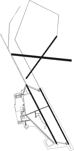
Groom Lake - Homey Airport
Airport details
| Country | United States of America |
| State | Nevada |
| Region | K2 |
| Airspace | Los Angeles Ctr |
| Municipality | Lincoln County |
| Elevation | 4490ft (1369m) |
| Timezone | GMT -8 |
| Coordinates | 37.24680, -115.81214 |
| Magnetic var | |
| Type | land |
| Available since | X-Plane v10.40 |
| ICAO code | KXTA |
| IATA code | n/a |
| FAA code | n/a |
Communication
| Homey Airport KDRA_ATIS | 119.675 |
| Homey Airport UNICOM | 122.800 |
| Homey Airport KXTA_Tower | 128.800 |
Approach frequencies
| ILS-cat-I | RW32 | 111.3 | 18.00mi |
| 3° GS | RW32 | 111.3 | 18.00mi |
Runway info
Nearby beacons
| code | identifier | dist | bearing | frequency |
|---|---|---|---|---|
| MCY | MICKEY (MERCURY) VORTAC | 0.9 | 102° | 117.50 |
| LMX | DME | 30.3 | 79° | 113.65 |
| INS | INDIAN SPRINGS TACAN | 40.3 | 168° | 114 |
| BTY | BEATTY VORTAC | 52.2 | 245° | 114.70 |
| TQQ | SILVERBOW (TONOPAH) VORTAC | 56.4 | 299° | 113 |
Departure and arrival routes
| Transition altitude | 18000ft |
| Transition level | 18000ft |
| SID end points | distance | outbound heading | |
|---|---|---|---|
| RW14 | |||
| TOMBA1 | 13mi | 232° | |
| JOBEE1 | 27mi | 328° | |
| RW32 | |||
| TOMBA1 | 13mi | 232° | |
| JOBEE1 | 27mi | 328° | |
Instrument approach procedures
| runway | airway (heading) | route (dist, bearing) |
|---|---|---|
| RW14-Y | JOKTU (133°) | JOKTU 10000ft HARTO (11mi, 112°) 9600ft |
| RNAV | HARTO 9600ft HANLA (7mi, 139°) 7400ft KXTA (9mi, 156°) 4497ft (6623mi, 108°) 4714ft HILVI (6621mi, 288°) 10500ft HILVI (turn) | |
| RW14-Z | FIRBA (86°) | FIRBA 10000ft ZIMLU (8mi, 3°) 9100ft ZEGAB (8mi, 66°) 7800ft |
| RNAV | ZEGAB 7800ft PEBDE (6mi, 141°) 6000ft WUPAV (3mi, 152°) 5300ft KXTA (3mi, 166°) 4482ft (6623mi, 108°) 4840ft FEMOX (6621mi, 288°) PUVTE (8mi, 249°) ZABUL (9mi, 272°) FIRBA (13mi, 357°) 10000ft FIRBA (turn) | |
| RW32-Y | JISMO (10°) | JISMO 10000ft JESGU (11mi, 71°) 7500ft |
| RNAV | JESGU 7500ft INIPE (8mi, 332°) 6900ft KXTA (10mi, 328°) 4545ft (6623mi, 108°) 4744ft JAPIV (6624mi, 288°) 10900ft JAPIV (turn) 12000ft | |
| RW32-Z | JOKVO (41°) | JOKVO 10000ft ZELGA (8mi, 90°) 8400ft SHIES (8mi, 69°) 7100ft |
| RW32-Z | ZELGA (10°) | ZELGA 8400ft SHIES (8mi, 69°) 7100ft |
| RNAV | SHIES 7100ft WODIK (4mi, 332°) 6600ft FEGUG (4mi, 332°) 5220ft KXTA (4mi, 324°) 4534ft (6623mi, 108°) 4840ft JUSOX (6624mi, 288°) ENITE (13mi, 252°) JOKVO (18mi, 160°) 10000ft JOKVO (turn) 14000ft |
Disclaimer
The information on this website is not for real aviation. Use this data with the X-Plane flight simulator only! Data taken with kind consent from X-Plane 12 source code and data files. Content is subject to change without notice.

