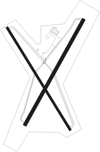
Zanesville - Zanesville Muni
Airport details
| Country | United States of America |
| State | Ohio |
| Region | K5 |
| Airspace | Indianapolis Ctr |
| Municipality | Muskingum County |
| Elevation | 895ft (273m) |
| Timezone | GMT -5 |
| Coordinates | 39.94444, -81.89208 |
| Magnetic var | |
| Type | land |
| Available since | X-Plane v10.40 |
| ICAO code | KZZV |
| IATA code | ZZV |
| FAA code | ZZV |
Communication
| Zanesville Muni CTAF/UNICOM | 123.000 |
Approach frequencies
| ILS-cat-I | RW22 | 109.95 | 18.00mi |
| 3° GS | RW22 | 109.95 | 18.00mi |
Nearby Points of Interest:
West Union School
-Alameda Apartments
-Zanesville YWCA
-Black-Elliott Block
-Masonic Temple Building
-United States Post Office and Federal Building
-Ralph Hardesty Stone House
-Muskingum County Courthouse
-Lafayette Lodge No. 79
-James Boggs Tannehill House
-Adena Court Apartments
-Perry Wiles Grocery Company
-West View
-Y-Bridge
-William Rainey Harper Log House
-St. John's Evangelical Lutheran Church
-Samuel Harper Stone House
-Barnett-Criss House
-Prospect Place
-Guernsey County Courthouse
-Adams-Gray House
-West School
-Broom Building
-McCracken-McFarland House
-Colonel Joseph Taylor House
Nearby beacons
| code | identifier | dist | bearing | frequency |
|---|---|---|---|---|
| ZZV | ZANESVILLE VOR/DME | 0.2 | 188° | 114.95 |
| CTW | DME | 25.6 | 56° | 111.80 |
| APE | APPLETON VORTAC | 34.3 | 287° | 116.70 |
| JPU | PARKERSBURG VOR/DME | 38.5 | 134° | 108.60 |
| UGS | UNIVERSITY (ATHENS) NDB | 42.6 | 199° | 250 |
| LC | PICKL (COLUMBUS) NDB | 43.6 | 266° | 376 |
| CFX | CADIZ NDB | 44 | 72° | 239 |
| PK | VERSI (PARKERSBURG) NDB | 45.5 | 149° | 388 |
| BSV | BRIGGS VOR/DME | 52.2 | 30° | 112.40 |
| MF | MANNS (MANSFIELD) NDB | 55.4 | 326° | 372 |
| MFD | MANSFIELD VORTAC | 64 | 323° | 108.80 |
Instrument approach procedures
| runway | airway (heading) | route (dist, bearing) |
|---|---|---|
| RW04 | RUTEE (41°) | RUTEE 2800ft |
| RNAV | RUTEE 2800ft CANSI (6mi, 41°) 2600ft GIRNS (3mi, 41°) 1500ft KZZV (2mi, 40°) 941ft (5032mi, 116°) 1150ft TWAES (5027mi, 296°) 2900ft TWAES (turn) | |
| RW22 | TWAES (221°) | TWAES 2900ft |
| RNAV | TWAES 2900ft PROLE (6mi, 221°) 2600ft NODSE (3mi, 221°) 1580ft KZZV (3mi, 222°) 917ft (5032mi, 116°) 1092ft RUTEE (5038mi, 296°) 2800ft RUTEE (turn) |
Disclaimer
The information on this website is not for real aviation. Use this data with the X-Plane flight simulator only! Data taken with kind consent from X-Plane 12 source code and data files. Content is subject to change without notice.

