Big Bear City
Airport details
| Country | United States of America |
| State | California |
| Region | K2 |
| Airspace | Los Angeles Ctr |
| Municipality | Big Bear City |
| Elevation | 6750ft (2057m) |
| Timezone | GMT -8 |
| Coordinates | 34.26378, -116.85603 |
| Magnetic var | |
| Type | land |
| Available since | X-Plane v10.40 |
| ICAO code | L35 |
| IATA code | RBF |
| FAA code | L35 |
Communication
| Big Bear City AWOS | 135.925 |
| Big Bear City Big Bear Unicom | 122.725 |
| Big Bear City LA Center | 126.350 |
Nearby Points of Interest:
Mill Creek Zanja
-Highland Historic District
-Gilman Ranch
-Redlands Central Railway Company Car Barn
-Redlands Santa Fe Depot District
-A. K. Smiley Public Library
-U.S. Post Office
-Auerbacher Home
-Smiley Park Historic District
-Beverly Ranch
-Barton Villa
-Integratron
-San Bernardino Downtown Station
-San Bernardino County Court House
-Peak Shelter Cabin
-Long Valley Ranger Station
-Palm Springs Aerial Tramway Mountain Station
-Harada House
-Riverside Municipal Auditorium
-Coachella Valley Savings No. 2
-Bono's Restaurant and Deli
Runway info
| Runway 8 / 26 | ||
| length | 1779m (5837ft) | |
| bearing | 90° / 270° | |
| width | 23m (75ft) | |
| surface | asphalt | |
| displ threshold | 114m (374ft) / 184m (604ft) | |
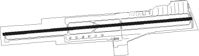
Airport layout
Taxiway locations
Parking locations
|
Nearby beacons
| code | identifier | dist | bearing | frequency |
|---|---|---|---|---|
| SB | PETIS (SAN BERNARDINO) NDB | 28.2 | 248° | 397 |
| RIV | MARCH (RIVERSIDE) TACAN | 29.9 | 230° | 113 |
| PSP | PALM SPRINGS VORTAC | 31.7 | 133° | 115.50 |
| VCV | VICTORVILLE VOR/DME | 33 | 302° | 109.05 |
| HDF | HOMELAND (RIVERSIDE) VOR | 33.5 | 214° | 113.40 |
| RAL | RIVERSIDE VOR | 34.8 | 243° | 112.40 |
| HEC | HECTOR VORTAC | 37.4 | 36° | 112.70 |
| PDZ | PARADISE (ONTARIO) VORTAC | 39.4 | 243° | 112.20 |
| DAG | DAGGETT VORTAC | 44.1 | 22° | 113.20 |
| POM | POMONA VORTAC | 47.5 | 259° | 110.40 |
| TRM | THERMAL VORTAC | 51.5 | 132° | 116.20 |
| ELB | EL TORO (SANTA ANA) VOR/DME | 56 | 236° | 117.20 |
| EDW | EDWARDS VORTAC | 61.1 | 309° | 116.40 |
| NFG | CAMP PENDLETON (OCEANSIDE TACAN | 65 | 208° | 111.80 |
Departure and arrival routes
| Transition altitude | 18000ft |
| Transition level | 18000ft |
| SID end points | distance | outbound heading | |
|---|---|---|---|
| RW08 | |||
| OKACO1 | 13mi | 90° | |
Instrument approach procedures
| runway | airway (heading) | route (dist, bearing) |
|---|---|---|
| RW26 | BRGET (242°) | BRGET BNNJA (7mi, 193°) 9400ft |
| RW26 | OKACO (270°) | OKACO BNNJA (4mi, 270°) 9400ft |
| RNAV | BNNJA 9400ft HALVI (4mi, 270°) 8700ft XEZUC (5mi, 270°) 7086ft (6721mi, 106°) 8800ft BRGET (6709mi, 286°) 11000ft BRGET (turn) |
Disclaimer
The information on this website is not for real aviation. Use this data with the X-Plane flight simulator only! Data taken with kind consent from X-Plane 12 source code and data files. Content is subject to change without notice.