Muchamiel
Airport details
| Country | Spain |
| State | Valencian Community |
| Region | LE |
| Airspace | Barcelona Ctr |
| Municipality | Mutxamel |
| Elevation | 475ft (145m) |
| Timezone | GMT +1 |
| Coordinates | 38.44000, -0.47389 |
| Magnetic var | |
| Type | land |
| Available since | X-Plane v10.40 |
| ICAO code | LEMU |
| IATA code | n/a |
| FAA code | n/a |
Communication
| Muchamiel A/A | 123.500 |
Nearby Points of Interest:
Convent de les Monges de la Sang, Alacant
-City walls of Alacant
-Gravina Museum of Fine Arts
-Casa consistorial de Alicante
-Casa Campos Carrera
-Casa Carbonell
-Edificio Roma
-Casa Lamaignere
-La Unión y el Fénix building, Alicante
-Casa de les Bruixes
-Torre Reixes
-Castell de Relleu
-Vila Joiosa station
-Xalet de Centella
-Town Hall of Castalla
-Ermita de la Sang, Castalla
-Castillo del Río
-Castle of Benifallim
-Torre Atalayola
-Fuente de El Molinar de Alcoy
-El Molinar d'Alcoi
-Mystery Play of Elche
-Torre de Ressemblanch
-Fábricas de Ferrándiz y Carbonell
-Hospital d'Oliver
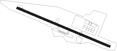
Runway info
| Runway 12 / 30 | ||
| length | 993m (3258ft) | |
| bearing | 112° / 292° | |
| width | 23m (75ft) | |
| surface | asphalt | |
Nearby beacons
| code | identifier | dist | bearing | frequency |
|---|---|---|---|---|
| ATE | ALICANTE VOR/DME | 10.6 | 216° | 114.65 |
| ALT | ALTET VOR/DME | 11.2 | 209° | 113.80 |
| AI | ALICANTE NDB | 12.3 | 232° | 330 |
| VSJ | SAN JAVIER VORTAC | 42.7 | 207° | 113 |
| TRL | ALCANTARILLA (MURCIA) TACAN | 46.2 | 237° | 116.60 |
| MUR | MURCIA VOR/DME | 49 | 225° | 114.85 |
| PND | PINEDO (VALENCIA) NDB | 60.1 | 7° | 340 |
Disclaimer
The information on this website is not for real aviation. Use this data with the X-Plane flight simulator only! Data taken with kind consent from X-Plane 12 source code and data files. Content is subject to change without notice.