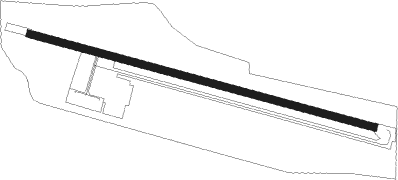
Requena
Airport details
| Country | Spain |
| State | Valencian Community |
| Region | LE |
| Airspace | Barcelona Ctr |
| Municipality | Requena |
| Elevation | 2338ft (713m) |
| Timezone | GMT +1 |
| Coordinates | 39.47535, -1.03735 |
| Magnetic var | |
| Type | land |
| Available since | X-Plane v10.40 |
| ICAO code | LERE |
| IATA code | n/a |
| FAA code | n/a |
Communication
| Requena Requena Tower | 123.325 |
Nearby Points of Interest:
Estación de El Rebollar
-Barri de la Vila, recinte medieval de Requena
-Finca Casa Nueva
-Solana de las Pilillas
-Castell i muralla d'Utiel
-Pico de los Ajos
-Church of Santos Reyes, Yátova
-Tomatina
-Castell de Xestalgar
-Kelin
-Macastre Church of the Transfiguration of the Lord
-castle of Domeño
-Torreta de Chiva
-Castle of Turís
-Castell de Xelva
-Torre de Godelleta
-Tuéjar town wall
-La Seña
-Ermita de San Cristóbal, Tuéjar
-Millares castle
-Chapel of Saint Cristopher, Camporrobles
-Barranco del Gallego diversion dam
-Castell de Vilamarxant
-Torre de Felx
-Yacimiento Tambuc Este
Runway info
| Runway 12 / 30 | ||
| length | 861m (2825ft) | |
| bearing | 105° / 285° | |
| width | 18m (59ft) | |
| surface | asphalt | |
Nearby beacons
| code | identifier | dist | bearing | frequency |
|---|---|---|---|---|
| CLS | CALLES (VALENCIA) VOR/DME | 14.1 | 12° | 117.55 |
| VLC | VALENCIA VOR/DME | 25.7 | 89° | 116.10 |
| EBT | BETERA NDB | 27.6 | 75° | 362 |
| PND | PINEDO (VALENCIA) NDB | 32.1 | 93° | 340 |
| SGO | SAGUNTO (VALENCIA) NDB | 40.2 | 77° | 356 |
| VAB | ALBACETE VOR/DME | 49.6 | 237° | 115.80 |
| TAB | ALBACETE TACAN | 49.8 | 237° | 108 |
| CTN | CASTELLON VOR/DME | 68.4 | 57° | 117.05 |
Disclaimer
The information on this website is not for real aviation. Use this data with the X-Plane flight simulator only! Data taken with kind consent from X-Plane 12 source code and data files. Content is subject to change without notice.
