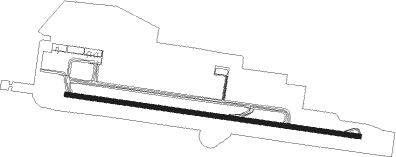
Ciudad Real
Airport details
| Country | Spain |
| State | Castile-La Mancha |
| Region | |
| Airspace | Madrid Ctr |
| Municipality | Ciudad Real |
| Elevation | 2083ft (635m) |
| Timezone | GMT +1 |
| Coordinates | 38.86044, -3.99255 |
| Magnetic var | |
| Type | land |
| Available since | X-Plane v10.40 |
| ICAO code | LERL |
| IATA code | CQM |
| FAA code | n/a |
Communication
| Ciudad Real AWOS | 128.800 |
| Ciudad Real EMERG | 121.500 |
| Ciudad Real Ground Control | 121.850 |
| Ciudad Real Tower | 118.050 |
| Ciudad Real APR | 123.700 |
| Ciudad Real Departure | 123.700 |
Nearby Points of Interest:
Castle of Caracuel
-Hermitage of the Virgen de Alarcos
-Bank of Spain building in Ciudad Real
-Cathedral of Ciudad Real
-House of the street Mercado Viejo
-Convent of the Merced, Ciudad Real
-Palacio de la Diputación Provincial de Ciudad Real
-Archivo Histórico Provincial de Ciudad Real
-Las Higueruelas
-Palacio de Torremejía
-El Torreon, Carrión de Calatrava
-Almagro
-Santuario de Nuestra Señora de las Nieves, Bolaños de Calatrava
-Fábrica de Harinas de Manzanares
-Church of Arenas de San Juan
Nearby beacons
| code | identifier | dist | bearing | frequency |
|---|---|---|---|---|
| EAL | ALMAGRO (CIUDAD REAL) NDB | 12.4 | 69° | 332 |
| BLN | BAILEN VOR/DME | 45.8 | 153° | 116.20 |
| VTB | VILLATOBAS VOR/DME | 60.4 | 30° | 112.70 |
Disclaimer
The information on this website is not for real aviation. Use this data with the X-Plane flight simulator only! Data taken with kind consent from X-Plane 12 source code and data files. Content is subject to change without notice.