Les Moëres - Dunkerque - Les Moeres
Airport details
| Country | France |
| State | Hauts-de-France |
| Region | LF |
| Airspace | Paris Ctr |
| Municipality | Ghyvelde |
| Elevation | 0ft (0m) |
| Timezone | GMT +1 |
| Coordinates | 51.04055, 2.55028 |
| Magnetic var | |
| Type | land |
| Available since | X-Plane v10.40 |
| ICAO code | LFAK |
| IATA code | n/a |
| FAA code | n/a |
Communication
| Dunkerque - Les Moeres ATC Freq | 123.500 |
| Dunkerque - Les Moeres KOKSIJDE Approach | 122.100 |
Nearby Points of Interest:
Église Saint-Nicolas de Zuydcoote
-Chapel of the Oblates
-Hôtel de ville d'Hondschoote
-Stalijzermolen, Leisele
-Town hall of Veurne
-Grote Markt
-Vleeshal
-Spaans Paviljoen
-City walls of Bergues
-Dunkirk city hall
-Passantenliedengasthuis
-Église Saint-Géry de Bierne
-Oude Zeedijkmolen
-Duinen van Ter Yde, Hannecartbos en Oostvoorduinen
-Ramskapelle train station
-Our Lady of the Fort Church
-Pervyse station
-Ganzepoot
-Sint-Joriskerk
-Viconia Kasteelhoeve
-Onze-Lieve-Vrouwehoekje
-Kanzel
-Bloemmolens
-Beukelaremolen
-Kapel Onze-Lieve-Vrouw-ter-Hulpe
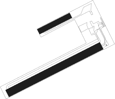
Runway info
Runway 07 / 25  | ||
| length | 639m (2096ft) | |
| bearing | 75° / 255° | |
| width | 50m (164ft) | |
| surface | grass | |
| Runway 07L / 25R | ||
| length | 200m (656ft) | |
| bearing | 76° / 256° | |
| width | 35m (115ft) | |
| surface | grass | |
| displ threshold | 20m (66ft) / 0m (0ft) | |
Nearby beacons
| code | identifier | dist | bearing | frequency |
|---|---|---|---|---|
| KOK | KOKSY VORTAC | 5 | 62° | 114.50 |
| DD | OOSTENDE (OOSTENDE-BRUGGE) NDB | 14.1 | 62° | 352 |
| OO | OOSTENDE (OOSTENDE-BRUGGE) NDB | 16.6 | 65° | 375 |
| MK | CALAIS-DUNKERQUE NDB | 18.9 | 265° | 418 |
| ONO | OOSTENDE NDB | 20.4 | 69° | 399 |
| MRV | MERVILLE NDB | 22.9 | 157° | 404 |
| MVC | MERVILLE NDB | 28.2 | 175° | 327 |
| ING | SAINT INGLEVERT NDB | 32 | 259° | 387 |
| BNE | BOULOGNE SUR MER VOR | 34.9 | 237° | 113.80 |
| LEQ | LILLE LESQUIN VOR/DME | 35.2 | 132° | 109 |
| COA | COSTA VOR/DME | 35.4 | 69° | 110.05 |
| MAK | MACKEL NDB | 36 | 95° | 360 |
| LL | LILLE NDB | 37.3 | 125° | 332 |
| VS | VALENCIENNES NDB | 51.4 | 131° | 317 |
| CMB | CAMBRAI EPINOY VOR/DME | 53.8 | 143° | 112.60 |
| ABB | ABBEVILLE VOR/DME | 60.4 | 218° | 108.45 |
Disclaimer
The information on this website is not for real aviation. Use this data with the X-Plane flight simulator only! Data taken with kind consent from X-Plane 12 source code and data files. Content is subject to change without notice.