Moulins/montbeugny - Moulins Montbeugny
Airport details
| Country | France |
| State | Auvergne-Rhône-Alpes |
| Region | LF |
| Airspace | Paris Ctr |
| Municipality | Toulon-sur-Allier |
| Elevation | 915ft (279m) |
| Timezone | GMT +1 |
| Coordinates | 46.53438, 3.42161 |
| Magnetic var | |
| Type | land |
| Available since | X-Plane v10.40 |
| ICAO code | LFHY |
| IATA code | XMU |
| FAA code | n/a |
Communication
| Moulins Montbeugny CTAF | 125.200 |
| Moulins Montbeugny Tower | 125.200 |
| Moulins Montbeugny Dep | 125.200 |
Nearby Points of Interest:
Vierge au croissant (Église Saint-Pierre, Yzeure)
-Couvent des Carmes de Moulins
-Anciennes Halles de Moulins
-Hôtel de Ballore
-Logis d'Henri IV
-Ancien collège des Jésuites
-Hôtel de Chavagnac (Moulins)
-Maison de Neuglize
-Prieuré-donjon de La Ferté-Hauterive
-Organ Clicquot of the Priory church in Souvigny
-Château des Sires de Bourbon, Souvigny
-Maison des Vertus cardinales
-Prieuré de Saint-Maurice
-Hôtel Calemard
-Maison Sévigné
-Remparts de Bourbon-Lancy
-Ancienne porte de ville de Billy
-maison du Marchand
-Porte de ville de Montaiguët-en-Forez
-Maison de Charles IX
-Église Sainte-Anne du Breuil
-Maison rue Saturnin-Arloing, Cusset
-Tour Prisonnière de Cusset
-Maison, Rue de la Goutte, Cusset
-Maison de Louis XI
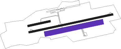
Runway info
Runway 08L / 26R  | ||
| length | 330m (1083ft) | |
| bearing | 85° / 265° | |
| width | 30m (98ft) | |
| surface | grass | |
| Runway 08 / 26 | ||
| length | 1301m (4268ft) | |
| bearing | 85° / 265° | |
| width | 30m (98ft) | |
| surface | asphalt | |
| Runway 08R / 26L | ||
| length | 844m (2769ft) | |
| bearing | 85° / 265° | |
| width | 80m (262ft) | |
| surface | grass | |
Nearby beacons
| code | identifier | dist | bearing | frequency |
|---|---|---|---|---|
| MOU | MOULINS VOR/DME | 13.5 | 51° | 116.70 |
| VZ | VICHY NDB | 24.4 | 184° | 403 |
| NV | NEVERS NDB | 27 | 331° | 394 |
| AV | AVORD NDB | 29 | 305° | 306 |
| SN | SAINT YAN NDB | 32.3 | 109° | 430 |
| RNN | ROANNE NDB | 35.9 | 124° | 358 |
| ROA | ROANNE VOR | 37.2 | 129° | 110.25 |
| TIS | THIERS VOR/DME | 39.5 | 169° | 117.50 |
| NEV | NEVERS VOR | 42.2 | 321° | 113.40 |
| AVD | AVORD NDB | 43.5 | 313° | 288 |
| ASM | CLERMONT-FERRAND/AUVERGNE NDB | 43.8 | 185° | 367 |
| AVD | AVORD TACAN | 45.2 | 303° | 110.60 |
| CFA | CLERMONT FERRAND AUVERGNE VOR/DME | 45.8 | 197° | 114.35 |
| EB | SAINT ETIENNE NDB | 64.7 | 136° | 379 |
Instrument approach procedures
| runway | airway (heading) | route (dist, bearing) |
|---|---|---|
| RW26 | HY410 (250°) | HY410 4000ft IHY26 (5mi, 169°) 3700ft |
| RW26 | HY411 (273°) | HY411 IHY26 (5mi, 298°) 3700ft |
| RW26 | MOU (231°) | MOU 4000ft HY410 (6mi, 118°) 4000ft IHY26 (5mi, 169°) 3700ft |
| RNAV | IHY26 3700ft FHY26 (5mi, 265°) 3700ft LFHY (9mi, 265°) 959ft HY430 (1mi, 265°) MOU (15mi, 54°) 3000ft |
Disclaimer
The information on this website is not for real aviation. Use this data with the X-Plane flight simulator only! Data taken with kind consent from X-Plane 12 source code and data files. Content is subject to change without notice.