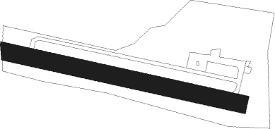
Saint Pardoux Et Vielic - Belves Saint Pardoux
Airport details
| Country | France |
| State | Nouvelle-Aquitaine |
| Region | LF |
| Airspace | Bordeaux Ctr |
| Municipality | Sarlat-la-Canéda |
| Elevation | 791ft (241m) |
| Timezone | GMT +1 |
| Coordinates | 44.78139, 0.95750 |
| Magnetic var | |
| Type | land |
| Available since | X-Plane v10.40 |
| ICAO code | LFIB |
| IATA code | n/a |
| FAA code | n/a |
Communication
| Belves Saint Pardoux A/A | 123.500 |
Nearby Points of Interest:
market hall of Belvès
-Combe-Capelle
-Chartreuse du Breuil
-Prieuré de Sainte-Croix-de-Beaumont
-Château de Sainte-Croix
-halle centrale de Monpazier
-roc de Marsal
-Porte de Luzier
-Dolmen de Peyre Nègre
-Château de Blanquefort-sur-Briolance
-Gisement préhistorique du Martinet
-croix de chemin de Sauveterre-la-Lémance
-abri du Facteur
-Forge du Moulinet
-église Saint-Front de Saint-Front-sur-Lémance
-Château de la Pommerie
-Monastère des Récollets
-Chapelle monolithe de Caudon
-Hôtel de Vienne
-Lanterne des morts de Sarlat-la-Canéda
-Manoir de Gisson
-Couvent Notre-Dame, Sarlat-la-Canéda
-prieuré Saint-Sardos de Laurenque
-Pech de l’Azé
-Château de Cuzorn
Nearby beacons
| code | identifier | dist | bearing | frequency |
|---|---|---|---|---|
| BGC | BERGERAC NDB | 14.5 | 276° | 374 |
| PX | PERIGUEUX NDB | 23.1 | 353° | 389 |
| CL | CAHORS NDB | 30.8 | 131° | 348 |
| BSC | SOUILLAC (BRIVE) NDB | 31 | 72° | 351 |
| FC | FIGEAC LIVERNON NDB | 36 | 98° | 395 |
| AG | AGEN NDB | 39.7 | 204° | 400 |
| SAU | SAUVETERRE DE GUYENNE VOR | 47.7 | 265° | 116.80 |
| AGN | AGEN VOR/DME | 53.7 | 185° | 114.80 |
| TLB | TOULOUSE NDB | 54.2 | 150° | 368 |
| BE | BORDEAUX NDB | 57.9 | 274° | 318 |
| AGO | ANGOULEME NDB | 60.1 | 330° | 404 |
| GAI | GAILLAC VOR | 62 | 134° | 115.80 |
| BD | BORDEAUX NDB | 65.3 | 276° | 393 |
| NB | BORDEAUX NDB | 67.7 | 284° | 361 |
| BMC | BORDEAUX MERIGNAC VOR/DME | 71.5 | 272° | 113.75 |
| OC | COGNAC NDB | 74.5 | 311° | 346 |
Disclaimer
The information on this website is not for real aviation. Use this data with the X-Plane flight simulator only! Data taken with kind consent from X-Plane 12 source code and data files. Content is subject to change without notice.
