Clarac - Saint Gaudens Montrejeau
Airport details
| Country | France |
| State | Occitania |
| Region | LF |
| Airspace | Bordeaux Ctr |
| Municipality | Clarac |
| Elevation | 1325ft (404m) |
| Timezone | GMT +1 |
| Coordinates | 43.10750, 0.61917 |
| Magnetic var | |
| Type | land |
| Available since | X-Plane v10.40 |
| ICAO code | LFIM |
| IATA code | n/a |
| FAA code | n/a |
Communication
| Saint Gaudens Montrejeau INFO | 120.425 |
Nearby Points of Interest:
Pont de Gourdan
-Grotte de Gourdan
-Chapelle Saint-Jean-des-Vignes de Saint-Plancard
-Cloister of Saint-Pierre et Saint-Gaudens
-Eglise de Saint-Pé-d'Ardet
-grottes de la Save
-Château de Latoue
-Chapel of Saint-Sernin, Pointis-Inard
-Aspet Fontaine
-Halle-mairie de Boulogne-sur-Gesse
-Gare de Sarrancolin
-église Notre-Dame-de-l'Assomption d'Ilhet
-église Saint-Pierre-aux-Liens d'Ardengost
-église Saint-Saturnin de Fréchet-Aure
-Église Notre-Dame-de-l'Assomption de Bareilles
-Église Saint-Vincent de Pouy
-église Saint-Martin d'Is
-Tour de Mayrègne
-église Saint-Martin d'Aspin-Aure
-église Saint-Étienne de Pailhac
-église Saint-Blaise de Ris
-Gare d'Arreau - Cadéac
-église Saint-Saturnin de Cazaux-Debat
-Église des Carmes de Trie-sur-Baïse
-casa Toquera
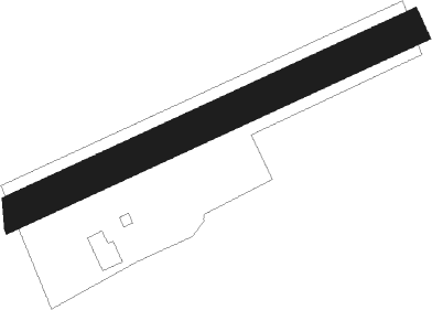
Runway info
| Runway 07 / 25 | ||
| length | 745m (2444ft) | |
| bearing | 75° / 255° | |
| width | 60m (197ft) | |
| surface | grass | |
| displ threshold | 0m (0ft) / 117m (384ft) | |
Nearby beacons
| code | identifier | dist | bearing | frequency |
|---|---|---|---|---|
| TBO | TARBES VOR/DME | 24.7 | 295° | 113.90 |
| TL | TARBES NDB | 27.1 | 288° | 321 |
| TW | TOULOUSE NDB | 30.9 | 44° | 406 |
| MUT | MURET NDB | 33.2 | 56° | 350 |
| LMB | LEMBEYE VOR | 35.2 | 299° | 111.80 |
| PO | PAU/PYRENEES NDB | 36.5 | 285° | 397 |
| LMT | AUCH NDB | 36.6 | 358° | 420 |
| TLF | FRANCAZAL NDB | 39.1 | 50° | 332 |
| PU | PAU/PYRENEES NDB | 42.4 | 283° | 364 |
| PMR | PAMIERS NDB | 42.8 | 91° | 384 |
| TS | TOULOUSE NDB | 44.8 | 65° | 423 |
| TOU | TOULOUSE BLAGNAC VOR/DME | 45.7 | 50° | 117.70 |
| AGN | AGEN VOR/DME | 48.1 | 18° | 114.80 |
| TLB | TOULOUSE NDB | 61.8 | 44° | 368 |
| LGH | MARSAN (MONT-DE-MARSAN) VOR/DME | 68.4 | 306° | 111.65 |
| MDM | MARSAN (MONT-DE-MARSAN) TACAN | 68.6 | 306° | 108.70 |
Disclaimer
The information on this website is not for real aviation. Use this data with the X-Plane flight simulator only! Data taken with kind consent from X-Plane 12 source code and data files. Content is subject to change without notice.