Chalon - Oyonnax-arbent
Airport details
| Country | France |
| State | Auvergne-Rhône-Alpes |
| Region | LF |
| Airspace | Marseille Ctr |
| Municipality | Arbent |
| Elevation | 1750ft (533m) |
| Timezone | GMT +1 |
| Coordinates | 46.27861, 5.66639 |
| Magnetic var | |
| Type | land |
| Available since | X-Plane v10.40 |
| ICAO code | LFLK |
| IATA code | n/a |
| FAA code | n/a |
Communication
| Oyonnax-Arbent OYONNAX CTAF | 123.500 |
| Oyonnax-Arbent Oyonnax Dep | 123.500 |
Nearby Points of Interest:
Lac Genin
-Borne frontière de la Buna
-Gare de La Cluse
-Grotte de Corveissiat
-Sanctuaire gallo-romain de Villards d’Héria
-Pont des Vents
-Chapelle des Carmes de Saint-Claude
-palais abbatial de Saint-Claude
-Fontaine-lavoir de Villechantria
-Lac d'Onoz
-Pont de Serrières-sur-Ain
-Town hall of Bellegarde-sur-Valserine
-Plateau de Retord
-Moulin à farine de Cerdon
-Table d'orientation de Montrond
-Habitat du premier âge féodal de Jasseron
-Allondon
-Moulin de Pertuizet
-Grotte de la Colombière
-Croix monumentale de Balanod
-Cintia Valeria Ramos
-Le Grand Lac de Clairvaux
-Hôtel-Dieu de Bourg-en-Bresse
-Immeuble, 10 rue Victor-Basch (Bourg-en-Bresse)
-Bourg-en-Bresse city hall
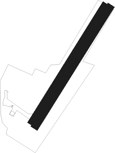
Runway info
Runway 04 / 22  | ||
| length | 871m (2858ft) | |
| bearing | 47° / 227° | |
| width | 30m (98ft) | |
| surface | asphalt | |
| displ threshold | 0m (0ft) / 100m (328ft) | |
| Runway 04R / 22L | ||
| length | 871m (2858ft) | |
| bearing | 47° / 227° | |
| width | 50m (164ft) | |
| surface | grass | |
| displ threshold | 0m (0ft) / 100m (328ft) | |
Nearby beacons
| code | identifier | dist | bearing | frequency |
|---|---|---|---|---|
| PAS | PASSEIRY VOR/DME | 15.4 | 109° | 116.60 |
| GVA | GENEVA VOR/DME | 19.3 | 93° | 115.75 |
| CBY | CHAMBERY VOR/DME | 24.1 | 167° | 115.40 |
| GLA | GLAND NDB | 25.1 | 77° | 375 |
| AT | ANNECY NDB | 29 | 140° | 384 |
| SPR | ST PREX VOR/DME | 34.3 | 76° | 113.90 |
| LAP | PRAZ DME | 39 | 62° | 110.65 |
| LSE | LYON SAINT EXUPERY VOR/DME | 40 | 227° | 114.75 |
| CH | CHAMBERY NDB | 42.2 | 162° | 346 |
| CC | CHAMPFORGEUIL NDB | 43.1 | 298° | 391 |
| DO | DOLE NDB | 44.6 | 333° | 309 |
| LTP | LA TOUR DU PIN VOR/DME | 48.3 | 196° | 115.55 |
| BR | LYON-BRON NDB | 48.7 | 225° | 388 |
| VNE | VIENNE REVENTIN VOR | 54.3 | 227° | 108.20 |
| EG | GRENOBLE NDB | 56 | 196° | 397 |
| WS | GRENOBLE NDB | 59 | 209° | 291 |
| BSV | BESANCON NDB | 63.3 | 28° | 370 |
| DJL | DIJON LONGVIC VOR/DME | 64 | 330° | 111.45 |
Disclaimer
The information on this website is not for real aviation. Use this data with the X-Plane flight simulator only! Data taken with kind consent from X-Plane 12 source code and data files. Content is subject to change without notice.