Saint-yan - Saint Yan
Airport details
| Country | France |
| State | Bourgogne-Franche-Comté |
| Region | LF |
| Airspace | Marseille Ctr |
| Municipality | L'Hôpital-le-Mercier |
| Elevation | 793ft (242m) |
| Timezone | GMT +1 |
| Coordinates | 46.40639, 4.02111 |
| Magnetic var | |
| Type | land |
| Available since | X-Plane v10.40 |
| ICAO code | LFLN |
| IATA code | SYT |
| FAA code | n/a |
Communication
| Saint Yan ATIS | 132.480 |
| Saint Yan Ground Control | 121.805 |
| Saint Yan Tower | 122.300 |
| Saint Yan Approach | 123.405 |
| Saint Yan Approach | 119.505 |
| Saint Yan Dep | 122.300 |
Approach frequencies
| ILS-cat-I | RW33R | 111.75 | 18.00mi |
| 3° GS | RW33R | 111.75 | 18.00mi |
Nearby Points of Interest:
Groupe scolaire Bellevue (Paray-le-Monial)
-Prieuré Notre-Dame de Paray-le-Monial
-Prieuré d'Anzy-le-Duc
-Couvent des Ursulines de Marcigny
-Hôtel de ville de Marcigny
-Maison Cudel de Montcolon
-Prieuré de la Sainte-Trinité de Marcigny-lès-Nonnains
-Maison mitoyenne de la Tour du Moulin
-Rigole l’Arroux
-Prieuré de Bragny
-Hôtel de ville de Semur-en-Brionnais
-Cinq pavillons Fillod
-Porte de ville de Montaiguët-en-Forez
-chapelle Saint-Benoît de Saint-Maurice-lès-Châteauneuf
-Briqueterie des Touillards-Vairet-Baudot
-Remparts de Bourbon-Lancy
-Maison Sévigné
-Stables of the Château Chaumont-Laguiche
-Église Sainte-Anne du Breuil
-Maison du syndicat des mineurs
-Dispensaire de la Croix Rouge
-War memorial of Montceau-les-Mines
-Édicule de Saint-André-le-Désert
-Doyenné de Bézornay
-Tuilerie de Bissy
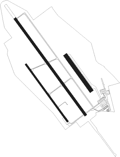
Runway info
Runway 15L / 33R  | ||
| length | 2032m (6667ft) | |
| bearing | 138° / 318° | |
| width | 45m (148ft) | |
| surface | asphalt | |
| Runway 15R / 33L | ||
| length | 1201m (3940ft) | |
| bearing | 138° / 318° | |
| width | 30m (98ft) | |
| surface | asphalt | |
| blast zone | 225m (738ft) / 0m (0ft) | |
| Runway 15 / 33 | ||
| length | 721m (2365ft) | |
| bearing | 138° / 318° | |
| width | 70m (230ft) | |
| surface | grass | |
Nearby beacons
| code | identifier | dist | bearing | frequency |
|---|---|---|---|---|
| SN | SAINT YAN NDB | 7.9 | 138° | 430 |
| RNN | ROANNE NDB | 17.6 | 177° | 358 |
| ROA | ROANNE VOR | 20.8 | 184° | 110.25 |
| MOU | MOULINS VOR/DME | 24.1 | 308° | 116.70 |
| VZ | VICHY NDB | 30.9 | 246° | 403 |
| TIS | THIERS VOR/DME | 37 | 222° | 117.50 |
| CC | CHAMPFORGEUIL NDB | 38.8 | 69° | 391 |
| ASM | CLERMONT-FERRAND/AUVERGNE NDB | 45.3 | 228° | 367 |
| EB | SAINT ETIENNE NDB | 47.4 | 161° | 379 |
| NV | NEVERS NDB | 47.5 | 303° | 394 |
| CFA | CLERMONT FERRAND AUVERGNE VOR/DME | 50.7 | 233° | 114.35 |
| BO | SAINT ETIENNE NDB | 54.4 | 163° | 299 |
| BR | LYON-BRON NDB | 62.4 | 129° | 388 |
| VNE | VIENNE REVENTIN VOR | 62.4 | 135° | 108.20 |
Departure and arrival routes
| Transition altitude | 5000ft |
| SID end points | distance | outbound heading | |
|---|---|---|---|
| RW15L | |||
| BUSI4S | 30mi | 99° | |
| LESP4S | 18mi | 192° | |
| TIS4S | 37mi | 222° | |
| SINP4S | 31mi | 264° | |
| MOU4S | 24mi | 308° | |
| RW33R | |||
| BUSI5N | 30mi | 99° | |
| LESP5N | 18mi | 192° | |
| TIS5N | 37mi | 222° | |
| MOU5N | 24mi | 308° | |
| STAR starting points | distance | inbound heading | |
|---|---|---|---|
| ALL | |||
| TIS4R, TIS4A | 37.0 | 42° | |
| CFA4A | 50.7 | 53° | |
| SINP4A | 30.9 | 84° | |
| MOU4A, MOU4C, MOU4G | 24.1 | 128° | |
| PIBA4A | 25.9 | 211° | |
| BUSI4A | 29.8 | 279° | |
| EB4R | 188.2 | 336° | |
| ONZO4R | 34.5 | 351° | |
Instrument approach procedures
| runway | airway (heading) | route (dist, bearing) |
|---|---|---|
| RW15L | LN400 (161°) | LN400 3700ft IN15L (5mi, 247°) 3700ft |
| RW15L | LN404 (120°) | LN404 3700ft IN15L (5mi, 67°) 3700ft |
| RW15L | MOU (128°) | MOU 4000ft IN15L (10mi, 114°) 3700ft |
| RNAV | IN15L 3700ft FN15L (5mi, 138°) 3700ft LFLN (10mi, 138°) 831ft LN410 (4mi, 138°) LN412 (6mi, 247°) GURGO (6mi, 293°) 3700ft GURGO (turn) 3700ft | |
| RW33R | GURGO (73°) | GURGO 3700ft LN500 (16mi, 125°) 3700ft IN33R (5mi, 67°) 3700ft |
| RW33R | LN500 (343°) | LN500 3700ft IN33R (5mi, 67°) 3700ft |
| RW33R | LN502 (318°) | LN502 4100ft IN33R (5mi, 318°) 3700ft |
| RW33R | LN504 (299°) | LN504 3700ft IN33R (5mi, 247°) 3700ft |
| RNAV | IN33R 3700ft FN33R (5mi, 318°) 3700ft LFLN (9mi, 318°) 848ft LN510 (5mi, 318°) GURGO (9mi, 225°) 3700ft GURGO (turn) 3700ft |
Holding patterns
| STAR name | hold at | type | turn | heading* | altitude | leg | speed limit |
|---|---|---|---|---|---|---|---|
| BUSI4A | SN | FIX | left | 147 (327)° | 3700ft - 8000ft | 1.0min timed | 210 |
| CFA4A | SN | FIX | left | 147 (327)° | 3700ft - 8000ft | 1.0min timed | 210 |
| EB4R | SN | FIX | left | 147 (327)° | 3700ft - 8000ft | 1.0min timed | 210 |
| MOU4A | MOU | NDB | right | 27 (207)° | 4000ft - 8000ft | 1.0min timed | 170 |
| MOU4A | SN | FIX | left | 147 (327)° | 3700ft - 8000ft | 1.0min timed | 210 |
| MOU4C | MOU | NDB | right | 27 (207)° | 4000ft - 8000ft | 1.0min timed | 170 |
| MOU4C | SN | FIX | left | 147 (327)° | 3700ft - 8000ft | 1.0min timed | 210 |
| MOU4G | GURGO | VHF | right | 337 (157)° | 3700ft - 7000ft | 1.0min timed | 220 |
| MOU4G | MOU | NDB | right | 27 (207)° | 4000ft - 8000ft | 1.0min timed | 170 |
| MOU4G | SN | FIX | left | 147 (327)° | 3700ft - 8000ft | 1.0min timed | 210 |
| ONZO4R | SN | FIX | left | 147 (327)° | 3700ft - 8000ft | 1.0min timed | 210 |
| PIBA4A | SN | FIX | left | 147 (327)° | 3700ft - 8000ft | 1.0min timed | 210 |
| SINP4A | SN | FIX | left | 147 (327)° | 3700ft - 8000ft | 1.0min timed | 210 |
| TIS4A | SN | FIX | left | 147 (327)° | 3700ft - 8000ft | 1.0min timed | 210 |
| TIS4R | SN | FIX | left | 147 (327)° | 3700ft - 8000ft | 1.0min timed | 210 |
| *) magnetic outbound (inbound) holding course | |||||||
Disclaimer
The information on this website is not for real aviation. Use this data with the X-Plane flight simulator only! Data taken with kind consent from X-Plane 12 source code and data files. Content is subject to change without notice.