Orange/caritat - Caritat Ab
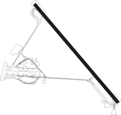
Airport details
| Country | France |
| State | Provence-Alpes-Côte d'Azur |
| Region | LF |
| Airspace | Marseille Ctr |
| Municipality | Orange |
| Elevation | 195ft (59m) |
| Timezone | GMT +1 |
| Coordinates | 44.13781, 4.85822 |
| Magnetic var | |
| Type | land |
| Available since | X-Plane v10.40 |
| ICAO code | LFMO |
| IATA code | XOG |
| FAA code | n/a |
Communication
| Caritat AB ORANGE Tower | 120.700 |
| Caritat AB ORANGE Tower | 122.100 |
| Caritat AB ORANGE Approach | 118.925 |
Approach frequencies
| ILS-cat-I | RW14 | 109.9 | 18.00mi |
| 2.5° GS | RW14 | 109.9 | 18.00mi |
Nearby Points of Interest:
Centre hospitalier cours Pourtoules d'Orange
-Hotel de Jonc
-Town hall of Orange
-Roman Gymnasium of Orange
-Ilot Pontillac
-Municipal Theatre of Orange
-Digue de Caderousse
-Castle of Châteauneuf-du-Pape
-Pipe organ of Collégiale Saint-Jean de Roquemaure
-Pont-Aqueduc des 5 cantons
-Tours de Saint-Laurent-des-Arbres
-Immeuble rue de la Porte-de-Monteux
-Former convent of the Order of the Visitation of Holy Mary in Carpentras
-Hôtel de Chabrol
-fontaine de la Bouquerie
-Roux Graineterie of Carpentras
-Palais de Justice de Carpentras
-collège de garçons de Carpentras
-Hôtel Poupardin
-Ancien hôtel Thomas-de-la-Valette de Carpentras
-Chapelle du Très-Saint-Crucifix
-Maison aux cariatides à Carpentras
-Couvent des Dominicains de Carpentras
-Maison cardinale
-Bibliothèque Inguimbertine

Nearby beacons
| code | identifier | dist | bearing | frequency |
|---|---|---|---|---|
| ORG | ORANGE TACAN | 0.3 | 79° | 109.40 |
| ORG | ORANGE NDB | 0.4 | 353° | 328 |
| AVN | AVIGNON VOR/DME | 9.8 | 218° | 114.60 |
| AN | CAUMONT DME-ILS | 13.7 | 169° | 110.50 |
| CM | AVIGNON CAUMONT NDB | 13.9 | 168° | 369 |
| MTL | MONTELIMAR ANCONE VOR/DME | 25.2 | 349° | 113.65 |
| NG | NIMES NDB | 25.7 | 238° | 354 |
| SCL | SAINT CHRISTOL NDB | 28.3 | 98° | 348 |
| NG | GARONS DME-ILS | 29.3 | 230° | 109.55 |
| DA | ALES CEVENNES NDB | 31.1 | 264° | 402 |
| SAL | SALON DE PROVENCE NDB | 33.3 | 155° | 334 |
| ITR | ISTRES LE TUBE NDB | 36.8 | 173° | 390 |
| ITS | ISTRES LE TUBE VOR/DME | 38.4 | 173° | 112.70 |
| MAR | MARSEILLE NDB | 40.7 | 157° | 383 |
| VE | VALENCE NDB | 42.9 | 8° | 320 |
| ALM | AIX LES MILLES NDB | 43.7 | 141° | 413 |
| MJ | MARSEILLE PROVENCE NDB | 44.7 | 153° | 406 |
| MTG | MARTIGUES VOR/DME | 46.2 | 163° | 117.30 |
| MS | MARSEILLE NDB | 48.6 | 150° | 343 |
| MRM | MARSEILLE PROVENCE VOR/DME | 49.9 | 148° | 108.80 |
| FG | MONTPELLIER NDB | 50.5 | 235° | 339 |
| FJR | MONTPELLIER MEDITERRANEE VOR/DME | 50.9 | 238° | 114.45 |
| OB | MARSEILLE PROVENCE NDB | 64.8 | 138° | 395 |
Instrument approach procedures
| runway | airway (heading) | route (dist, bearing) |
|---|---|---|
| RW14 | MO401 (124°) | MO401 MO403 (6mi, 112°) 3400ft IMO14 (5mi, 112°) 2200ft |
| RW14 | MO402 (99°) | MO402 5000ft MO404 (6mi, 62°) 3300ft IMO14 (4mi, 62°) 2200ft |
| RW14 | MO404 (117°) | MO404 3300ft IMO14 (4mi, 62°) 2200ft |
| RNAV | IMO14 2200ft FMO14 (5mi, 135°) 2200ft LFMO (7mi, 139°) 244ft MO407 (4mi, 128°) 3500ft MO404 (16mi, 299°) 3500ft | |
| RW32 | MO412 (105°) | MO412 MO413 (8mi, 140°) 3600ft MO414 (10mi, 121°) 2200ft IMO32 (2mi, 67°) 2200ft |
| RNAV | IMO32 2200ft FMO32 (4mi, 320°) 2200ft MMO32 (6mi, 320°) 267ft MO417 (8mi, 320°) 3600ft MO412 (6mi, 247°) |
Disclaimer
The information on this website is not for real aviation. Use this data with the X-Plane flight simulator only! Data taken with kind consent from X-Plane 12 source code and data files. Content is subject to change without notice.