Perpignan/rivesaltes - Perpignan Rivesaltes
Airport details
| Country | France |
| State | Occitania |
| Region | LF |
| Airspace | Marseille Ctr |
| Municipality | Perpignan |
| Elevation | 144ft (44m) |
| Timezone | GMT +1 |
| Coordinates | 42.74083, 2.86972 |
| Magnetic var | |
| Type | land |
| Available since | X-Plane v10.40 |
| ICAO code | LFMP |
| IATA code | PGF |
| FAA code | n/a |
Communication
| Perpignan Rivesaltes PERPIGNAN ATIS | 127.875 |
| Perpignan Rivesaltes PERPIGNAN Tower | 118.300 |
| Perpignan Rivesaltes MONTPELLIER Approach | 130.850 |
| Perpignan Rivesaltes MONTPELLIER Approach | 131.050 |
| Perpignan Rivesaltes MONTPELLIER Approach | 127.275 |
Approach frequencies
| ILS-cat-I | RW33 | 111.75 | 18.00mi |
| 3° GS | RW33 | 111.75 | 18.00mi |
Nearby Points of Interest:
Église Saint Jean l'évangéliste de Peyrestortes
-Maison Julia
-Palais de la Députation
-Hôtel de ville de Perpignan
-Couvent des Frères Prêcheurs
-Hôtel Saint-Antoine
-Casa Xanxo
-Inlaid stone in font de na Pincarda
-Hôtel de Senesterra
-bourse du travail de Perpignan
-Hôtel Pams
-Caserne Saint-Jacques
-Couvent Sainte Claire de Perpignan
-monument aux morts de 1870-71
-Église des Carmes
-Ruscino
-Église Sainte-Colombe de Cases-de-Pène
-Château de Saint-Hippolyte
-colonne milliaire de Saint-Hippolyte
-Église de Saint-Hippolyte
-Porte fortifiée de Pézilla-la-Rivière
-Église Sainte-Marie de Las Fonts
-Église Saint-Laurent de Saint-Laurent-de-la-Salanque
-Thuir war memorial
-Archway rue Constantin, Elne
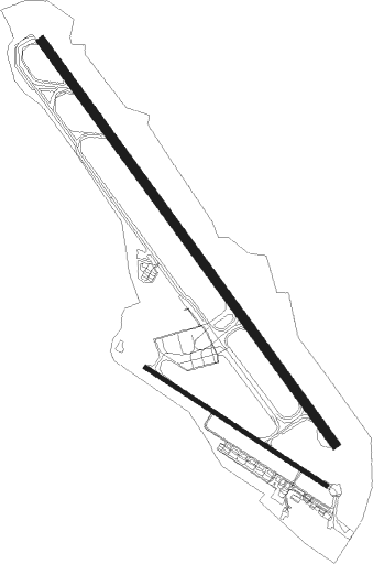
Runway info
Runway 15 / 33  | ||
| length | 2499m (8199ft) | |
| bearing | 140° / 320° | |
| width | 45m (148ft) | |
| surface | asphalt | |
| displ threshold | 0m (0ft) / 170m (558ft) | |
| blast zone | 70m (230ft) / 70m (230ft) | |
| Runway 13 / 31 | ||
| length | 1084m (3556ft) | |
| bearing | 119° / 299° | |
| width | 20m (66ft) | |
| surface | asphalt | |
| blast zone | 160m (525ft) / 0m (0ft) | |
Nearby beacons
| code | identifier | dist | bearing | frequency |
|---|---|---|---|---|
| PPG | PERPIGNAN RIVESALTES VOR/DME | 0.5 | 349° | 117.20 |
| PL | RIVESALTES (PERPIGNAN) NDB | 4.4 | 138° | 351 |
| ZR | BEZIERS VIAS NDB | 39.6 | 35° | 397 |
| ZR | VIAS DME-ILS | 40.7 | 39° | 109.35 |
| CS | CARCASSONNE SALVAZA NDB | 41 | 306° | 345 |
| SAL | SAINTE LEOCADIE NDB | 41.8 | 251° | 418 |
| GRN | GERONA (GIRONA) NDB | 43 | 185° | 412 |
| GIR | GERONA (GIRONA) VOR/DME | 48.8 | 187° | 114.10 |
| G | GIRONA NDB | 49.1 | 187° | 330 |
| BGR | BAGUR VOR/DME | 49.9 | 157° | 112.20 |
| CVU | CASTRES-MAZAMET NDB | 60.8 | 323° | 356 |
Departure and arrival routes
| Transition altitude | 5000ft |
| SID end points | distance | outbound heading | |
|---|---|---|---|
| RW15 | |||
| SIJA4S | 28mi | 8° | |
| BAMG4S, BAMG4L | 11mi | 50° | |
| FJR4S | 70mi | 53° | |
| SUBI4S | 78mi | 81° | |
| BGR4S | 50mi | 157° | |
| ORBI4S | 32mi | 320° | |
| KELA4S | 26mi | 360° | |
| RW33 | |||
| SIJA4N | 28mi | 8° | |
| BAMG4N, BAMG4R | 11mi | 50° | |
| FJR4N | 70mi | 53° | |
| SUBI4N | 78mi | 81° | |
| BGR4N | 50mi | 157° | |
| ORBI4N | 32mi | 320° | |
| KELA4N | 26mi | 360° | |
| STAR starting points | distance | inbound heading | |
|---|---|---|---|
| ALL | |||
| ORBI2P | 31.6 | 140° | |
| KELA2P | 25.8 | 180° | |
| SIJA2P | 27.5 | 188° | |
| FJR2P | 69.8 | 233° | |
| SUBI2P | 78.4 | 261° | |
| KANI2P | 16.4 | 336° | |
Instrument approach procedures
| runway | airway (heading) | route (dist, bearing) |
|---|---|---|
| RW15 | BAMGO (230°) | BAMGO MP502 (15mi, 301°) 5000ft IMP15 (6mi, 245°) 4500ft |
| RW15 | MP502 (163°) | MP502 5000ft IMP15 (6mi, 245°) 4500ft |
| RW15 | MP503 (140°) | MP503 IMP15 (7mi, 140°) 4500ft |
| RNAV | IMP15 4500ft FMP15 (5mi, 140°) 4500ft LFMP (12mi, 141°) 179ft MP510 (8mi, 139°) LANET (8mi, 59°) 3000ft LANET (turn) 3000ft | |
| RW33-Y | LANET (279°) | LANET MP400 (6mi, 173°) 2000ft IMP33 (5mi, 266°) 2000ft |
| RNAV | IMP33 2000ft FP33Y (5mi, 320°) 2000ft LFMP (6mi, 319°) 186ft LFMP (turn) 480ft BAMGO (11mi, 50°) 3000ft MP411 (3mi, 126°) 3000ft LANET (9mi, 173°) 3000ft LANET (turn) 3000ft | |
| RW33-Z | LANET (279°) | LANET MP400 (6mi, 173°) 2000ft IMP33 (5mi, 266°) 2000ft |
| RNAV | IMP33 2000ft FP33Z (5mi, 320°) 2000ft LFMP (6mi, 319°) 186ft MP410 (1mi, 326°) 3000ft BAMGO (11mi, 56°) 3000ft MP411 (3mi, 126°) 3000ft LANET (9mi, 173°) 3000ft LANET (turn) 3000ft |
Holding patterns
| STAR name | hold at | type | turn | heading* | altitude | leg | speed limit |
|---|---|---|---|---|---|---|---|
| FJR2P | LANET | VHF | right | 284 (104)° | 3000ft - 7000ft | DME 3.5mi | 220 |
| KANI2P | LANET | VHF | right | 284 (104)° | 3000ft - 7000ft | DME 3.5mi | 220 |
| KELA2P | LANET | VHF | right | 284 (104)° | 3000ft - 7000ft | DME 3.5mi | 220 |
| ORBI2P | LANET | VHF | right | 284 (104)° | 3000ft - 7000ft | DME 3.5mi | 220 |
| SIJA2P | LANET | VHF | right | 284 (104)° | 3000ft - 7000ft | DME 3.5mi | 220 |
| SUBI2P | LANET | VHF | right | 284 (104)° | 3000ft - 7000ft | DME 3.5mi | 220 |
| *) magnetic outbound (inbound) holding course | |||||||
Disclaimer
The information on this website is not for real aviation. Use this data with the X-Plane flight simulator only! Data taken with kind consent from X-Plane 12 source code and data files. Content is subject to change without notice.