Avignon/caumont - Avignon Caumont
Airport details
| Country | France |
| State | Provence-Alpes-Côte d'Azur |
| Region | LF |
| Airspace | Marseille Ctr |
| Municipality | Avignon |
| Elevation | 124ft (38m) |
| Timezone | GMT +1 |
| Coordinates | 43.91386, 4.89737 |
| Magnetic var | |
| Type | land |
| Available since | X-Plane v10.32 |
| ICAO code | LFMV |
| IATA code | AVN |
| FAA code | n/a |
Communication
| Avignon Caumont LFMV ATIS | 120.825 |
| Avignon Caumont AVIGNON Tower | 122.600 |
| Avignon Caumont PROVENCE Approach | 131.225 |
| Avignon Caumont AVIGNON Approach | 120.875 |
| Avignon Caumont ORANGE Approach | 118.925 |
Nearby Points of Interest:
Château de Durette
-église Saint-Thomas de Vedène
-Hotel de Rochegude
-Hôpital Sainte-Marthe d'Avignon
-Maison du IV de Chiffre
-Bains Pommer (Avignon)
-Chapelle de la Visitation, Avignon
-Aumône générale
-cloître des Carmes
-Church of the Célestins of Avignon
-Hôtel particulier de Félix
-Hotel de Raoulx
-Hôtel Fortia de Montréal
-Chapelle des Pénitents Violets
-Chapelle Sainte Catherine
-Livrée de Ceccano
-Avignon - Grenier à Sel
-Hotel de Madon de Chateaublanc
-Hotel Galeans des Issarts
-Chapellerie Mouret
-Hôtel d'Adhémar de Cransac
-Arcades romaines d'Avignon
-Collège Saint Nicolas d'Annnecy à Avignon
-palais des papes d'Avignon - Chapelle Saint Marial
-Desmarets de Montdevergues mansion
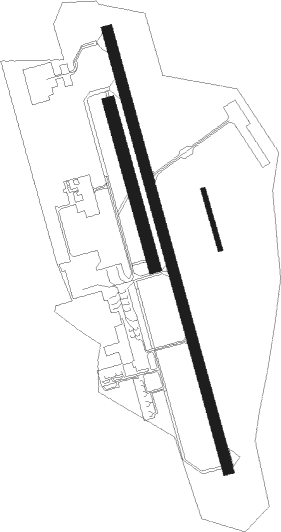
Runway info
Runway 17 / 35  | ||
| length | 1880m (6168ft) | |
| bearing | 165° / 345° | |
| width | 45m (148ft) | |
| surface | asphalt | |
| displ threshold | 201m (659ft) / 310m (1017ft) | |
| Runway 17L / 35R | ||
| length | 251m (823ft) | |
| bearing | 165° / 345° | |
| width | 20m (66ft) | |
| surface | grass | |
| Runway 17R / 35L | ||
| length | 700m (2297ft) | |
| bearing | 165° / 345° | |
| width | 50m (164ft) | |
| surface | grass | |
Nearby beacons
| code | identifier | dist | bearing | frequency |
|---|---|---|---|---|
| AN | CAUMONT DME-ILS | 0.2 | 116° | 110.50 |
| CM | AVIGNON CAUMONT NDB | 0.4 | 125° | 369 |
| AVN | AVIGNON VOR/DME | 8.1 | 298° | 114.60 |
| ORG | ORANGE TACAN | 13.6 | 352° | 109.40 |
| ORG | ORANGE NDB | 14 | 350° | 328 |
| SAL | SALON DE PROVENCE NDB | 20.2 | 146° | 334 |
| NG | NIMES NDB | 21.5 | 263° | 354 |
| NG | GARONS DME-ILS | 22.6 | 253° | 109.55 |
| ITR | ISTRES LE TUBE NDB | 23.3 | 175° | 390 |
| ITS | ISTRES LE TUBE VOR/DME | 24.9 | 174° | 112.70 |
| SCL | SAINT CHRISTOL NDB | 27.4 | 77° | 348 |
| MAR | MARSEILLE NDB | 27.5 | 151° | 383 |
| ALM | AIX LES MILLES NDB | 31.7 | 131° | 413 |
| MJ | MARSEILLE PROVENCE NDB | 31.7 | 146° | 406 |
| MTG | MARTIGUES VOR/DME | 32.7 | 160° | 117.30 |
| DA | ALES CEVENNES NDB | 33.8 | 281° | 402 |
| MS | MARSEILLE NDB | 35.7 | 144° | 343 |
| MRM | MARSEILLE PROVENCE VOR/DME | 37.2 | 141° | 108.80 |
| MTL | MONTELIMAR ANCONE VOR/DME | 38.8 | 350° | 113.65 |
| FG | MONTPELLIER NDB | 43.9 | 248° | 339 |
| FJR | MONTPELLIER MEDITERRANEE VOR/DME | 44.8 | 250° | 114.45 |
| OB | MARSEILLE PROVENCE NDB | 52.9 | 132° | 395 |
| VE | VALENCE NDB | 56.2 | 4° | 320 |
Departure and arrival routes
| Transition altitude | 5000ft |
| SID end points | distance | outbound heading | |
|---|---|---|---|
| RW17 | |||
| TRET6S | 47mi | 121° | |
| LACA6S | 32mi | 146° | |
| NG6S | 254mi | 269° | |
| RARU6S | 14mi | 325° | |
| MTL6S | 39mi | 350° | |
| RW35 | |||
| TRET6N | 47mi | 121° | |
| LACA6N | 32mi | 146° | |
| NG6N | 254mi | 269° | |
| RARU6N | 14mi | 325° | |
| MTL6N | 39mi | 350° | |
| STAR starting points | distance | inbound heading | |
|---|---|---|---|
| ALL | |||
| NG5C | 253.9 | 89° | |
| MEN5C | 85.4 | 112° | |
| MTL5C | 38.8 | 170° | |
| LACA5C | 31.7 | 326° | |
Instrument approach procedures
| runway | airway (heading) | route (dist, bearing) |
|---|---|---|
| RW17-X | CM (305°) | CM 3000ft MV410 (4mi, 342°) 3000ft MV412 (4mi, 300°) 2200ft MV414 (3mi, 341°) 1800ft IV17X (3mi, 86°) 1800ft |
| RNAV | IV17X 1800ft FV17X (4mi, 165°) 1800ft LFMV (5mi, 167°) 162ft MV416 (2mi, 160°) CM (2mi, 353°) 3000ft CM (turn) | |
| RW17-Y | CM (305°) | CM 3000ft MV402 (5mi, 37°) MV404 (5mi, 345°) 3000ft IV17Y (3mi, 262°) 1800ft |
| RNAV | IV17Y 1800ft FV17Y (3mi, 165°) 1800ft LFMV (5mi, 167°) 162ft MV416 (2mi, 160°) CM (2mi, 353°) 3000ft CM (turn) | |
| RW17-Z | ORG (175°) | ORG 3200ft ARMIV (2mi, 249°) 3200ft |
| RNAV | ARMIV 3200ft FV17Z (3mi, 165°) 3200ft LFMV (10mi, 166°) 162ft MV416 (2mi, 160°) CM (2mi, 353°) 3000ft CM (turn) |
Holding patterns
| STAR name | hold at | type | turn | heading* | altitude | leg | speed limit |
|---|---|---|---|---|---|---|---|
| LACA5C | CM | FIX | left | 206 (26)° | 3000ft - 7000ft | 1.0min timed | 170 |
| MEN5C | ORG | FIX | right | 350 (170)° | 3200ft - 4200ft | 1.0min timed | 170 |
| MTL5C | CM | FIX | left | 206 (26)° | 3000ft - 7000ft | 1.0min timed | 170 |
| MTL5C | ORG | FIX | right | 350 (170)° | 3200ft - 4200ft | 1.0min timed | 170 |
| NG5C | CM | FIX | left | 206 (26)° | 3000ft - 7000ft | 1.0min timed | 170 |
| *) magnetic outbound (inbound) holding course | |||||||
Disclaimer
The information on this website is not for real aviation. Use this data with the X-Plane flight simulator only! Data taken with kind consent from X-Plane 12 source code and data files. Content is subject to change without notice.