Salon - Salon De Provence
Airport details
| Country | France |
| State | Provence-Alpes-Côte d'Azur |
| Region | LF |
| Airspace | Marseille Ctr |
| Municipality | Salon de Provence |
| Elevation | 195ft (59m) |
| Timezone | GMT +1 |
| Coordinates | 43.60468, 5.10804 |
| Magnetic var | |
| Type | land |
| Available since | X-Plane v10.40 |
| ICAO code | LFMY |
| IATA code | n/a |
| FAA code | n/a |
Communication
| Salon de Provence SALON Tower | 122.100 |
| Salon de Provence SALON Tower | 130.300 |
| Salon de Provence SALON Approach | 135.150 |
Approach frequencies
| ILS-cat-I | RW16 | 110.9 | 18.00mi |
| 3° GS | RW16 | 110.9 | 18.00mi |
Nearby Points of Interest:
Borne milliaire de Bidoussanne
-Borne milliaire
-Borne milliaire de la Calanque
-Pipe organ of Notre-Dame-de-l'Assomption (Lambesc)
-Pont suspendu sur la Durance
-Vieux château de Mérindol
-Marseille Provence Airport
-Oppidum de Pierredon à Éguilles
-Lavoir de Lauris
-Fort de Bouc
-Oratoire Notre-Dame d'Aix-en-Provence
-Château de la Corée
-Arch of Cavaillon
-maison canoniale de Cavaillon
-hôtel de Pérussis
-Cavaillon - Hotel d'Agar
-synagogue of Cavaillon
-Chapelle Saint Benoit
-Hôtel Dieu de Cavaillon
-Porte d’Avignon
-Abbaye de Saint-Hilaire
-Fontaine publique (Lourmarin)
-Pont à coquille sur l'Aigue Brun
-Pavillon Vendôme
-Thermes romains d'Aix-en-Provence
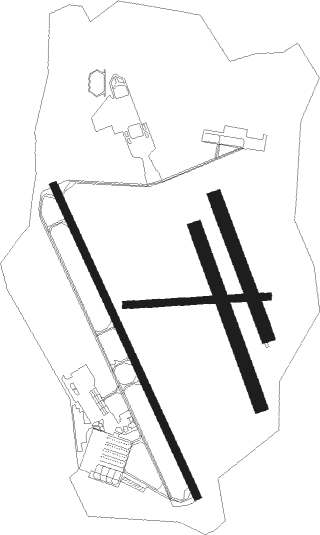
Runway info
Runway 16 / 34  | ||
| length | 2003m (6572ft) | |
| bearing | 153° / 333° | |
| width | 45m (148ft) | |
| surface | asphalt | |
| Runway 16R / 34L | ||
| length | 1101m (3612ft) | |
| bearing | 159° / 339° | |
| width | 80m (262ft) | |
| surface | grass | |
| Runway 16L / 34R | ||
| length | 861m (2825ft) | |
| bearing | 158° / 338° | |
| width | 79m (259ft) | |
| surface | grass | |
| Runway 09 / 27 | ||
| length | 836m (2743ft) | |
| bearing | 91° / 271° | |
| width | 42m (138ft) | |
| surface | grass | |
Nearby beacons
| code | identifier | dist | bearing | frequency |
|---|---|---|---|---|
| SAL | SALON DE PROVENCE NDB | 0.4 | 311° | 334 |
| MAR | MARSEILLE NDB | 7 | 166° | 383 |
| ITR | ISTRES LE TUBE NDB | 9 | 246° | 390 |
| ITR | ISTRES LE TUBE TACAN | 9.1 | 247° | 115.70 |
| ITS | ISTRES LE TUBE VOR/DME | 9.6 | 238° | 112.70 |
| MJ | MARSEILLE PROVENCE NDB | 11 | 147° | 406 |
| ALM | AIX LES MILLES NDB | 12.6 | 111° | 413 |
| MTG | MARTIGUES VOR/DME | 13.1 | 186° | 117.30 |
| MS | MARSEILLE NDB | 15 | 141° | 343 |
| MRM | MARSEILLE PROVENCE VOR/DME | 16.6 | 136° | 108.80 |
| CM | AVIGNON CAUMONT NDB | 20.2 | 326° | 369 |
| AN | CAUMONT DME-ILS | 20.4 | 326° | 110.50 |
| AVN | AVIGNON VOR/DME | 28.2 | 317° | 114.60 |
| NG | GARONS DME-ILS | 31.5 | 283° | 109.55 |
| SCL | SAINT CHRISTOL NDB | 31.7 | 42° | 348 |
| OB | MARSEILLE PROVENCE NDB | 33.1 | 124° | 395 |
| ORG | ORANGE TACAN | 33.7 | 336° | 109.40 |
| NG | NIMES NDB | 34 | 290° | 354 |
| ORG | ORANGE NDB | 34.2 | 335° | 328 |
| MFB | BRIGNOLES NDB | 41.1 | 102° | 688 |
| DGN | DIGNE VOR | 48.9 | 69° | 113.85 |
| DA | ALES CEVENNES NDB | 50.1 | 296° | 402 |
| MTL | MONTELIMAR ANCONE VOR/DME | 58.8 | 341° | 113.65 |
Instrument approach procedures
| runway | airway (heading) | route (dist, bearing) |
|---|---|---|
| RW16 | MY401 (182°) | MY401 4000ft MY402 (4mi, 220°) 3100ft IMY16 (3mi, 219°) 2300ft |
| RNAV | IMY16 2300ft FMY16 (3mi, 153°) 2000ft MMY16 (5mi, 153°) 563ft MY406 (3mi, 153°) 4000ft MY407 (5mi, 75°) 4000ft MY408 (10mi, 358°) 4000ft MY401 (6mi, 301°) 4000ft MY401 (turn) 4000ft |
Disclaimer
The information on this website is not for real aviation. Use this data with the X-Plane flight simulator only! Data taken with kind consent from X-Plane 12 source code and data files. Content is subject to change without notice.