Avord
Airport details
| Country | France |
| State | Centre-Val de Loire |
| Region | LF |
| Airspace | Paris Ctr |
| Municipality | Farges-en-Septaine |
| Elevation | 580ft (177m) |
| Timezone | GMT +1 |
| Coordinates | 47.05695, 2.63889 |
| Magnetic var | |
| Type | land |
| Available since | X-Plane v10.32 |
| ICAO code | LFOA |
| IATA code | n/a |
| FAA code | n/a |
Communication
| Avord Tower AVORD | 122.100 |
| Avord Approach AVORD | 119.700 |
Approach frequencies
| ILS-cat-I | RW24 | 110.7 | 18.00mi |
| 3° GS | RW24 | 110.7 | 18.00mi |
Nearby Points of Interest:
Église Saint-Amand de Saint-Denis-de-Palin
-Remparts gallo-romains de Bourges
-Palais archiépiscopal de Bourges
-Maison forte de Mornay
-Portail Saint-Ursin
-Couvent des Augustins de Bourges
-hotel de panette - un chateau en ville
-abbaye Saint-Ambroix de Bourges
-Prefecture hotel of Cher
-Collège des Jésuites de Bourges
-Halle au blé de Bourges
-Hôtel-Dieu de Bourges
-Porte de Dun-sur-Auron
-Château de Dun-sur-Auron
-Fortifications de Dun-sur-Auron
-Bourges, Lycée Marguerite de Navarre
-Château de Maupas
-Buildings by ceramist Jean Linard
-Ancienne église Saint-Pierre
-Église Saint-Martin de Vallenay
-Église Notre-Dame de Nevers
-tour Goguin
-Faïencerie de l'Autruche
-Notre-Dame de Pitié
-Hôtel de ville de Nevers
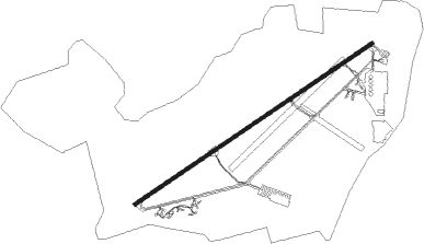
Runway info
| Runway 06 / 24 | ||
| length | 3497m (11473ft) | |
| bearing | 69° / 249° | |
| width | 45m (148ft) | |
| surface | asphalt | |
| blast zone | 255m (837ft) / 255m (837ft) | |
Nearby beacons
| code | identifier | dist | bearing | frequency |
|---|---|---|---|---|
| AVD | AVORD TACAN | 0.3 | 277° | 110.60 |
| AVD | AVORD NDB | 7.6 | 68° | 288 |
| NEV | NEVERS VOR | 13.2 | 72° | 113.40 |
| BRG | BOURGES NDB | 14.8 | 264° | 375 |
| AV | AVORD NDB | 15.8 | 121° | 306 |
| NV | NEVERS NDB | 23.3 | 100° | 394 |
| CTX | CHATEAUROUX DEOLS NDB | 35 | 262° | 428 |
| MOU | MOULINS VOR/DME | 45.8 | 109° | 116.70 |
| LPD | MONTLUCON-GUERET NDB | 46.9 | 202° | 398 |
| ORS | ORLEANS SAINT DENIS DE L'HOTEL NDB | 55.2 | 336° | 322 |
| AX | AUXERRE NDB | 62.5 | 45° | 417 |
| VZ | VICHY NDB | 63.9 | 141° | 403 |
| BCY | ORLEANS VOR/DME | 66.2 | 316° | 117.35 |
| OAN | ORLEANS-BRICY NDB | 66.7 | 317° | 385 |
Departure and arrival routes
| Transition altitude | 5000ft |
| SID end points | distance | outbound heading | |
|---|---|---|---|
| RW06 | |||
| OSKI2E | 51mi | 50° | |
| NEV2E | 13mi | 72° | |
| MOU2E | 46mi | 109° | |
| MENO2E | 38mi | 130° | |
| LEMI2E | 37mi | 142° | |
| CTX2E | 35mi | 262° | |
| AMB2E | 68mi | 283° | |
| MOTA2E | 36mi | 321° | |
| RW24 | |||
| MOU2W | 46mi | 109° | |
| MENO2W | 38mi | 130° | |
| LEMI2W | 37mi | 142° | |
| CTX2W | 35mi | 262° | |
| AMB2W | 68mi | 283° | |
Instrument approach procedures
| runway | airway (heading) | route (dist, bearing) |
|---|---|---|
| RW06 | OA402 (85°) | OA402 3100ft IOA06 (5mi, 140°) 2600ft |
| RW06 | OA404 (69°) | OA404 3100ft IOA06 (5mi, 69°) 2600ft |
| RW06 | OA406 (50°) | OA406 3500ft IOA06 (5mi, 320°) 2600ft |
| RNAV | IOA06 2600ft FOA06 (5mi, 69°) 2600ft LFOA (8mi, 69°) 595ft OA412 (5mi, 68°) 3500ft OA414 (13mi, 137°) 3500ft OA406 (20mi, 266°) 3500ft | |
| RW24 | OA401 (232°) | OA401 3100ft IOA24 (5mi, 166°) 2600ft |
| RW24 | OA403 (249°) | OA403 3100ft IOA24 (5mi, 249°) 2600ft |
| RW24 | OA405 (263°) | OA405 3500ft IOA24 (5mi, 300°) 2600ft |
| RNAV | IOA24 2600ft FOA24 (5mi, 249°) 2600ft LFOA (7mi, 248°) 626ft OA413 (6mi, 249°) 3500ft OA415 (15mi, 112°) 3500ft OA405 (15mi, 36°) 3500ft |
Disclaimer
The information on this website is not for real aviation. Use this data with the X-Plane flight simulator only! Data taken with kind consent from X-Plane 12 source code and data files. Content is subject to change without notice.