Évreux/fauville - Evreux Fauville
Airport details
| Country | France |
| State | Normandy |
| Region | LF |
| Airspace | Paris Ctr |
| Municipality | Huest |
| Elevation | 462ft (141m) |
| Timezone | GMT +1 |
| Coordinates | 49.02861, 1.22000 |
| Magnetic var | |
| Type | land |
| Available since | X-Plane v10.40 |
| ICAO code | LFOE |
| IATA code | EVX |
| FAA code | n/a |
Communication
| Evreux Fauville EVREUX ATIS | 138.225 |
| Evreux Fauville EVREUX Ground Control | 122.100 |
| Evreux Fauville EVREUX Tower | 119.700 |
| Evreux Fauville EVREUX Tower | 125.375 |
| Evreux Fauville EVREUX Approach | 118.125 |
| Evreux Fauville EVREUX Departure | 118.125 |
Approach frequencies
| ILS-cat-I | RW22 | 111.3 | 18.00mi |
| 3° GS | RW22 | 111.3 | 18.00mi |
Nearby Points of Interest:
Théâtre Municipal d'Évreux
-Rempart gallo-romain d'Évreux
-Église Saint-Taurin d'Évreux
-Petit Château de Navarre
-Château de La Croix-Saint-Leufroy
-Église Notre-Dame de Cocherel
-Forêt d'Évreux
-Alignement des Bruyères
-Dolmen de l'Hôtel-Dieu
-Château des Rotoirs
-Pont des Planches
-chartreuse d'Aubevoye
-Île aux Bœufs
-Manoir du Clos-de-l'Aître
-Château de Château-Neuf
-Town hall of Vernon, Eure
-immeuble Benac
-maison du Temps Jadis
-kiosque à musique
-Convent of Saint-Louis-Sainte-Élisabeth
-Abbaye Saint-Pierre-et-Saint-Paul de Châtillon-lès-Conches
-Grange dîmière de Daubeuf-la-Campagne
-Croix de Surtauville
-Menhir de la Basse-Crémonville
-Fort de Boutavant
Runway info
Runway 04 / 22  | ||
| length | 2998m (9836ft) | |
| bearing | 52° / 232° | |
| width | 45m (148ft) | |
| surface | asphalt | |
| Runway 04L / 22R | ||
| length | 998m (3274ft) | |
| bearing | 52° / 232° | |
| width | 30m (98ft) | |
| surface | grass | |
Airport layout
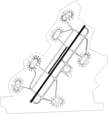
Taxiway locations
Parking locations
Nearby beacons
| code | identifier | dist | bearing | frequency |
|---|---|---|---|---|
| EVX | EVREUX FAUVILLE VORTAC | 0.1 | 16° | 112.40 |
| ROU | ROUEN VALLEE DE SEINE VOR | 26.3 | 8° | 116.80 |
| EPR | EPERNON VOR/DME | 29.7 | 133° | 115.65 |
| HOL | VILLACOUBLAY NDB | 29.7 | 116° | 315 |
| LGL | L'AIGLE VOR/DME | 30.7 | 251° | 112.70 |
| PON | PONTOISE CORMEILLES EN VE VOR | 32.3 | 85° | 111.60 |
| CHW | CHARTRES VOR/DME | 34.2 | 203° | 115.20 |
| RBT | RAMBOUILLET VOR/DME | 37.9 | 116° | 114.70 |
| TA | VILLACOUBLAY NDB | 37.9 | 106° | 286 |
| TSU | TOUSSUS LE NOBLE VOR | 38.5 | 107° | 108.25 |
| DVL | DEAUVILLE NORMANDIE VOR | 39.4 | 287° | 110.20 |
| BV | BEAUVAIS NDB | 42.1 | 60° | 391 |
| BOV | BEAUVAIS TILLE VOR/DME | 44 | 66° | 109.65 |
| DSA | DIEPPE NDB | 51.5 | 351° | 351 |
| DPE | DIEPPE VOR | 53.8 | 357° | 115.80 |
| CAD | CHATEAUDUN VOR/DME | 58.6 | 170° | 115.95 |
| CHN | CHATEAUDUN TACAN | 58.7 | 171° | 110.20 |
| CNE | CAEN NDB | 60.8 | 273° | 404 |
| CAN | CAEN CARPIQUET VOR/DME | 66.4 | 275° | 114.45 |
Instrument approach procedures
| runway | airway (heading) | route (dist, bearing) |
|---|---|---|
| RW04 | OE401 (27°) | OE401 2200ft IOE04 (5mi, 319°) 2100ft |
| RW04 | OE402 (52°) | OE402 2700ft IOE04 (5mi, 52°) 2100ft |
| RW04 | OE403 (70°) | OE403 3200ft IOE04 (5mi, 103°) 2100ft |
| RNAV | IOE04 2100ft FOE04 (5mi, 52°) 2100ft LFOE (6mi, 52°) 498ft OE406 (5mi, 52°) OE407 (6mi, 299°) 2200ft OE403 (18mi, 226°) 3200ft | |
| RW22 | OE421 (208°) | OE421 2200ft IOE22 (5mi, 139°) 2100ft |
| RW22 | OE422 (232°) | OE422 2400ft IOE22 (5mi, 232°) 2100ft |
| RNAV | IOE22 2100ft FOE22 (5mi, 232°) 2100ft LFOE (6mi, 232°) 504ft OE426 (5mi, 232°) OE427 (6mi, 299°) 2200ft OE421 (17mi, 57°) 2200ft |
Disclaimer
The information on this website is not for real aviation. Use this data with the X-Plane flight simulator only! Data taken with kind consent from X-Plane 12 source code and data files. Content is subject to change without notice.