Isles-lès-villenoy - Meaux Esbly
Airport details
| Country | France |
| State | Ile-de-France |
| Region | LF |
| Airspace | Paris Ctr |
| Municipality | Isles-lès-Villenoy |
| Elevation | 214ft (65m) |
| Timezone | GMT +1 |
| Coordinates | 48.92694, 2.83389 |
| Magnetic var | |
| Type | land |
| Available since | X-Plane v10.40 |
| ICAO code | LFPE |
| IATA code | n/a |
| FAA code | n/a |
Communication
| Meaux Esbly ATIS/V | 126.725 |
| Meaux Esbly Tower | 120.150 |
| Meaux Esbly Dep | 120.150 |
Nearby Points of Interest:
Fontaine Saint-Fursy
-Lagny Abbey
-Immeuble des Cinq Pignons
-Pierre de Chilpéric
-Petit Château de Montfermeil
-Poudrerie nationale de Sevran-Livry
-Town hall of Clichy-sous-Bois
-Croix de Jouarre
-Crypte Saint-Paul
-Hospital of Ville-Évrard
-Commanderie de Coulommiers
-Chapelle Sainte-Aubierge
-Ancienne prison (Coulommiers)
-Colombier de Mauperthuis
-Moulin de Mistou
-Gymnase Léopold Bellan
-Gare de Bry-sur-Marne
-Château de Bry
-Château des Carneaux
-église Saint-Pierre et Saint-Paul, Vémars
-Fort de Champigny
-Église Notre-Dame-de-l'Assomption d'Ormesson-sur-Marne
-Château d'Ormesson
-Château Royal du Vivier
-Viaduc ferroviaire de Nogent-sur-Marne
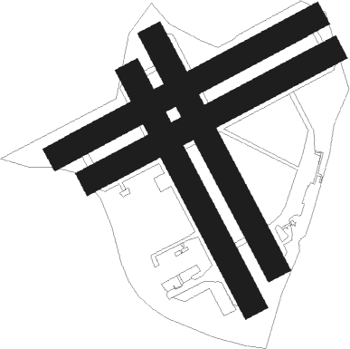
Runway info
Runway 07L / 25R  | ||
| length | 1146m (3760ft) | |
| bearing | 74° / 254° | |
| width | 100m (328ft) | |
| surface | grass | |
| Runway 07R / 25L | ||
| length | 1076m (3530ft) | |
| bearing | 74° / 254° | |
| width | 100m (328ft) | |
| surface | grass | |
| Runway 16L / 34R | ||
| length | 1021m (3350ft) | |
| bearing | 147° / 327° | |
| width | 100m (328ft) | |
| surface | grass | |
| displ threshold | 0m (0ft) / 100m (328ft) | |
| Runway 16R / 34L | ||
| length | 1021m (3350ft) | |
| bearing | 147° / 327° | |
| width | 100m (328ft) | |
| surface | grass | |
| displ threshold | 0m (0ft) / 95m (312ft) | |
Nearby beacons
| code | identifier | dist | bearing | frequency |
|---|---|---|---|---|
| CLM | COULOMMIERS VOR/DME | 8.6 | 115° | 112.90 |
| PGS | CHARLES-DE-GAULLE (PARIS) VOR/DME | 9.3 | 289° | 117.05 |
| CGN | (PARIS) DME | 14.2 | 286° | 115.35 |
| BT | LE BOURGET (PARIS) VOR/DME | 15.2 | 277° | 116.10 |
| BSN | DME | 17.9 | 40° | 114.85 |
| POY | ORLY (PARIS) NDB | 21.1 | 246° | 334 |
| MV | MELUN NDB | 23.1 | 159° | 434 |
| MLN | MELUN VILLAROCHE VOR/DME | 28.3 | 183° | 113.60 |
| TA | VILLACOUBLAY NDB | 30.5 | 258° | 286 |
| TSU | TOUSSUS LE NOBLE VOR | 30.7 | 257° | 108.25 |
| CTL | CHATILLON SUR MARNE VOR/DME | 31.9 | 74° | 117.60 |
| PON | PONTOISE CORMEILLES EN VE VOR | 33 | 282° | 111.60 |
| BRY | BRAY SUR SEINE VOR/DME | 36.1 | 138° | 114.10 |
| RBT | RAMBOUILLET VOR/DME | 37 | 252° | 114.70 |
| MTD | MONTDIDIER VOR | 39.9 | 331° | 113.65 |
| BOV | BEAUVAIS TILLE VOR/DME | 40.6 | 307° | 109.65 |
| BV | BEAUVAIS NDB | 46.3 | 305° | 391 |
| PTV | PITHIVIERS VOR | 51.5 | 216° | 116.50 |
| GI | AMIENS NDB | 56.6 | 339° | 339 |
| ORS | ORLEANS SAINT DENIS DE L'HOTEL NDB | 63.9 | 211° | 322 |
Disclaimer
The information on this website is not for real aviation. Use this data with the X-Plane flight simulator only! Data taken with kind consent from X-Plane 12 source code and data files. Content is subject to change without notice.