Merville/calonne - Merville Calonne
Airport details
| Country | France |
| State | Hauts-de-France |
| Region | LF |
| Airspace | Paris Ctr |
| Municipality | Lestrem |
| Elevation | 60ft (18m) |
| Timezone | GMT +1 |
| Coordinates | 50.61660, 2.64009 |
| Magnetic var | |
| Type | land |
| Available since | X-Plane v10.40 |
| ICAO code | LFQT |
| IATA code | HZB |
| FAA code | n/a |
Communication
| Merville Calonne MERVILLE ATIS | 127.905 |
| Merville Calonne MERVILLE Ground Control | 121.680 |
| Merville Calonne MERVILLE Tower | 119.075 |
| Merville Calonne LILLE Approach | 120.275 |
| Merville Calonne LILLE Approach | 126.475 |
Approach frequencies
| ILS-cat-I | RW22 | 109.35 | 18.00mi |
| 3.5° GS | RW22 | 109.35 | 18.00mi |
Nearby Points of Interest:
Hôtel de Beaulaincourt
-Église Saint-Vaast de Béthune
-Town hall of Béthune
-prévôté
-Église Saint-Jean-Baptiste de Steenwerck
-chartreuse de Val-Saint-Esprit
-Chartreuse des Dames à Gonaye
-Église Notre-Dame-de-Lourdes de Hazebrouck
-Fosse n° 2 des mines de Marles
-Fosse n° 1 - 1 bis des mines de Nœux
-Goutte de lait de la Compagnie des mines de Marles
-Château Mercier
-City walls of Aire-sur-la-Lys
-Ancienne brasserie Motte-Cordonnier
-Piscine Roger-Salengro
-Bailiwick of Aire-sur-la-Lys
-Refuge de l'abbaye Saint-Augustin de Clarques
-Église Saint-Jacques-le-Majeur-et-Saint-Ignace d'Aire-sur-la-Lys
-Ancienne école de natation
-Fosse n° 7 - 7 bis des mines de Nœux
-EPSM Lille-Métropole
-fosse n° 5 des mines de Meurchin
-Fosse n° 5 des mines de Meurchin
-Fosse n° 13 bis des mines de Lens
-Église Saint-Louis de Grenay
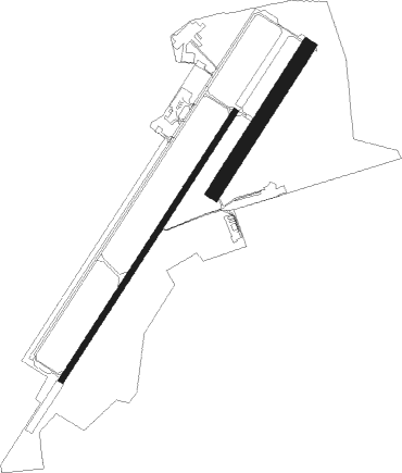
Runway info
Runway 04 / 22  | ||
| length | 1837m (6027ft) | |
| bearing | 50° / 230° | |
| width | 30m (98ft) | |
| surface | asphalt | |
| displ threshold | 60m (197ft) / 0m (0ft) | |
| Runway 04R / 22L | ||
| length | 992m (3255ft) | |
| bearing | 50° / 230° | |
| width | 80m (262ft) | |
| surface | grass | |
Nearby beacons
| code | identifier | dist | bearing | frequency |
|---|---|---|---|---|
| MVC | MERVILLE NDB | 3.3 | 230° | 327 |
| MRV | MERVILLE NDB | 4.1 | 50° | 404 |
| LEQ | LILLE LESQUIN VOR/DME | 17.4 | 97° | 109 |
| LL | LILLE NDB | 21.9 | 94° | 332 |
| BNE | BOULOGNE SUR MER VOR | 27.9 | 271° | 113.80 |
| KOK | KOKSY VORTAC | 28.7 | 1° | 114.50 |
| CMB | CAMBRAI EPINOY VOR/DME | 30.4 | 127° | 112.60 |
| VS | VALENCIENNES NDB | 31.5 | 110° | 317 |
| MK | CALAIS-DUNKERQUE NDB | 31.8 | 303° | 418 |
| DD | OOSTENDE (OOSTENDE-BRUGGE) NDB | 35.4 | 19° | 352 |
| OO | OOSTENDE (OOSTENDE-BRUGGE) NDB | 36.7 | 24° | 375 |
| ING | SAINT INGLEVERT NDB | 37.7 | 287° | 387 |
| MAK | MACKEL NDB | 38.6 | 68° | 360 |
| ONO | OOSTENDE NDB | 38.8 | 32° | 399 |
| ABY | ALBERT BRAY NDB | 39 | 165° | 321 |
| ABB | ABBEVILLE VOR/DME | 41.7 | 238° | 108.45 |
| GI | AMIENS NDB | 46.8 | 191° | 339 |
| COA | COSTA VOR/DME | 51.5 | 44° | 110.05 |
Departure and arrival routes
| Transition altitude | 5000ft |
| SID end points | distance | outbound heading | |
|---|---|---|---|
| RW04 | |||
| LEQ7N | 17mi | 97° | |
| ABB7N | 42mi | 238° | |
| TRAC7N | 29mi | 289° | |
| RW22 | |||
| LEQ7S | 17mi | 97° | |
| ABB7S | 42mi | 238° | |
| TRAC7S | 29mi | 289° | |
| STAR starting points | distance | inbound heading | |
|---|---|---|---|
| RW04 | |||
| ABB8M | 19.8 | 81° | |
| CMB8A, LEQ8M, MATI8A | 17.4 | 277° | |
| CMB8M | 12.4 | 325° | |
| RW22 | |||
| ABB8M | 19.8 | 81° | |
| MATI8A, LEQ8M, CMB8A | 17.4 | 277° | |
| CMB8M | 12.4 | 325° | |
Instrument approach procedures
| runway | airway (heading) | route (dist, bearing) |
|---|---|---|
| RW04 | ELNUX (15°) | ELNUX QT405 (3mi, 296°) 2700ft ABROM (2mi, 296°) 2000ft |
| RW04 | ODENI (74°) | ODENI ABROM (5mi, 116°) 2000ft |
| RW04 | SUSON (50°) | SUSON ABROM (5mi, 50°) 2000ft |
| RNAV | ABROM 2000ft FQT04 (4mi, 50°) 2000ft LFQT (5mi, 50°) 111ft PIMIX (7mi, 50°) REVGO (4mi, 296°) ODENI (16mi, 234°) 2000ft ODENI (turn) 2000ft | |
| RW22 | OKSOK (87°) | OKSOK OXUBA (15mi, 56°) 4000ft MAGIP (3mi, 116°) 2500ft |
| RW22 | OXUBA (209°) | OXUBA 4000ft MAGIP (3mi, 116°) 2500ft |
| RNAV | MAGIP 2500ft FQT22 (3mi, 230°) 2500ft LFQT (7mi, 230°) 110ft QT510 (4mi, 230°) OKSOK (5mi, 295°) 2500ft |
Holding patterns
| STAR name | hold at | type | turn | heading* | altitude | leg | speed limit |
|---|---|---|---|---|---|---|---|
| ABB8M | MRV | FIX | right | 37 (217)° | 2500ft - 4000ft | 1.0min timed | 170 |
| ABB8M | MVC | FIX | left | 217 (37)° | 2000ft - 5000ft | 1.0min timed | 200 |
| BNE8A | MRV | FIX | right | 37 (217)° | 2500ft - 4000ft | 1.0min timed | 170 |
| BNE8A | MVC | FIX | left | 217 (37)° | 2000ft - 5000ft | 1.0min timed | 200 |
| CMB8A | LEQ | NDB | left | 275 (95)° | 2000ft - 7000ft | 1.0min timed | 220 |
| CMB8A | MRV | FIX | right | 37 (217)° | 2500ft - 4000ft | 1.0min timed | 170 |
| CMB8A | MVC | FIX | left | 217 (37)° | 2000ft - 5000ft | 1.0min timed | 200 |
| CMB8M | MRV | FIX | right | 37 (217)° | 2500ft - 4000ft | 1.0min timed | 170 |
| CMB8M | MVC | FIX | left | 217 (37)° | 2000ft - 5000ft | 1.0min timed | 200 |
| IBER8M | MRV | FIX | right | 37 (217)° | 2500ft - 4000ft | 1.0min timed | 170 |
| IBER8M | MVC | FIX | left | 217 (37)° | 2000ft - 5000ft | 1.0min timed | 200 |
| LEQ8M | LEQ | NDB | left | 275 (95)° | 2000ft - 7000ft | 1.0min timed | 220 |
| LEQ8M | MRV | FIX | right | 37 (217)° | 2500ft - 4000ft | 1.0min timed | 170 |
| LEQ8M | MVC | FIX | left | 217 (37)° | 2000ft - 5000ft | 1.0min timed | 200 |
| MATI8A | LEQ | NDB | left | 275 (95)° | 2000ft - 7000ft | 1.0min timed | 220 |
| MATI8A | MRV | FIX | right | 37 (217)° | 2500ft - 4000ft | 1.0min timed | 170 |
| MATI8A | MVC | FIX | left | 217 (37)° | 2000ft - 5000ft | 1.0min timed | 200 |
| TRAC8A | MRV | FIX | right | 37 (217)° | 2500ft - 4000ft | 1.0min timed | 170 |
| TRAC8A | MVC | FIX | left | 217 (37)° | 2000ft - 5000ft | 1.0min timed | 200 |
| *) magnetic outbound (inbound) holding course | |||||||
Disclaimer
The information on this website is not for real aviation. Use this data with the X-Plane flight simulator only! Data taken with kind consent from X-Plane 12 source code and data files. Content is subject to change without notice.