Pleurtuit - Dinard Pleurtuit-st Malo
Airport details
| Country | France |
| State | Brittany |
| Region | LF |
| Airspace | Brest Ctr |
| Municipality | Pleurtuit |
| Elevation | 219ft (67m) |
| Timezone | GMT +1 |
| Coordinates | 48.58770, -2.07995 |
| Magnetic var | |
| Type | land |
| Available since | X-Plane v10.40 |
| ICAO code | LFRD |
| IATA code | DNR |
| FAA code | n/a |
Communication
| Dinard Pleurtuit-St Malo ATIS | 124.580 |
| Dinard Pleurtuit-St Malo DINARD Tower | 120.150 |
| Dinard Pleurtuit-St Malo RENNES Approach | 126.950 |
| Dinard Pleurtuit-St Malo Dep | 120.150 |
Nearby Points of Interest:
Ancien prieuré de Dinard
-immeuble
-Rance Tidal Power Station
-pont sur le Frémur
-Calvaire de Saint-Lunaire
-Cale sèche de la Landriais
-Villa Les Roches Brunes
-Malouinière du Bosc
-Solidor Tower
-Ar Zenith
-Malouinière de la Plussinais
-Pont roulant de Saint-Malo à Saint-Servan
-Couvent des Récollets
-Maison, 3 rue d'Orléans, Saint-Malo
-Hôtel Magon de la Lande
-Hôtel de la Bertaudière
-Notre-Dame de la Grand'Porte
-Hôtel Hay
-Hôtel de la Gicquelais
-Maison du Peuple de Saint-Malo
-Malouinière de la Chipaudière
-Malouinière de Launay-Ravilly
-Malouinière du Demaine
-Pointe de la Varde
-Malouinière de la Grande Gâtinais
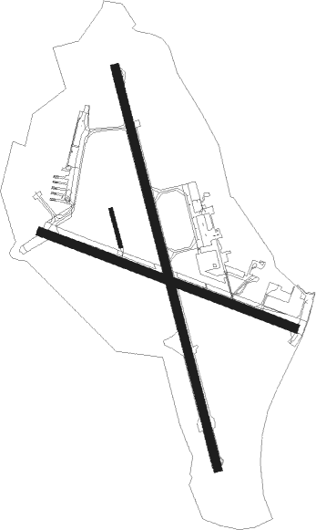
Runway info
Runway 17 / 35  | ||
| length | 2202m (7224ft) | |
| bearing | 165° / 345° | |
| width | 45m (148ft) | |
| surface | asphalt | |
| Runway 12 / 30 | ||
| length | 1447m (4747ft) | |
| bearing | 107° / 287° | |
| width | 45m (148ft) | |
| surface | asphalt | |
| displ threshold | 0m (0ft) / 155m (509ft) | |
| blast zone | 0m (0ft) / 53m (174ft) | |
| Runway 17R / 35L | ||
| length | 200m (656ft) | |
| bearing | 165° / 345° | |
| width | 20m (66ft) | |
| surface | grass | |
Nearby beacons
| code | identifier | dist | bearing | frequency |
|---|---|---|---|---|
| DIN | DINARD PLEURTUIT SAINT MA VOR/DME | 0.1 | 235° | 114.30 |
| SB | SAINT BRIEUC NDB | 27.9 | 268° | 353 |
| REN | RENNES SAINT JACQUES VOR/DME | 33.9 | 147° | 109.25 |
| JW | JERSEY NDB | 37.5 | 347° | 329 |
| JSY | JERSEY VOR/DME | 38 | 3° | 112.20 |
| PNT | PONTIVY NDB | 43 | 233° | 377 |
| VA | VANNES NDB | 54.3 | 215° | 342 |
| GUR | GUERNSEY VOR/DME | 55 | 328° | 109.40 |
Departure and arrival routes
| Transition altitude | 5000ft |
| SID end points | distance | outbound heading | |
|---|---|---|---|
| RW17 | |||
| MINQ2S | 27mi | 3° | |
| EKRA2S | 30mi | 62° | |
| RW35 | |||
| MINQ2N | 27mi | 3° | |
| EKRA2N | 30mi | 62° | |
Instrument approach procedures
| runway | airway (heading) | route (dist, bearing) |
|---|---|---|
| RW17 | DINVI (201°) | DINVI 3000ft ERTUN (6mi, 263°) 3000ft |
| RW17 | URITI (135°) | URITI 3000ft ERTUN (6mi, 83°) 3000ft |
| RNAV | ERTUN 3000ft FRD17 (5mi, 165°) 3000ft LFRD (8mi, 165°) 243ft RD710 (1mi, 165°) 3000ft RD712 (8mi, 290°) 3000ft URITI (10mi, 345°) 3000ft ERTUN (6mi, 83°) 3000ft ERTUN (turn) 6000ft | |
| RW35 | ABOTI (308°) | ABOTI RD504 (6mi, 165°) EVREN (5mi, 263°) 3000ft |
| RNAV | EVREN 3000ft FRD35 (6mi, 345°) 3000ft LFRD (9mi, 345°) 248ft RD510 (6mi, 345°) 3000ft RD512 (5mi, 83°) 3000ft ABOTI (16mi, 165°) 3000ft ABOTI (turn) 6000ft |
Disclaimer
The information on this website is not for real aviation. Use this data with the X-Plane flight simulator only! Data taken with kind consent from X-Plane 12 source code and data files. Content is subject to change without notice.