Nantes - Nantes Atlantique
Airport details
| Country | France |
| State | Pays de la Loire |
| Region | LF |
| Airspace | Brest Ctr |
| Municipality | Bouguenais |
| Elevation | 87ft (27m) |
| Timezone | GMT +1 |
| Coordinates | 47.15702, -1.60781 |
| Magnetic var | |
| Type | land |
| Available since | X-Plane v10.40 |
| ICAO code | LFRS |
| IATA code | NTE |
| FAA code | n/a |
Communication
| Nantes Atlantique NANTES ATIS | 126.925 |
| Nantes Atlantique NANTES Ground Control | 121.650 |
| Nantes Atlantique NANTES Tower | 118.650 |
| Nantes Atlantique NANTES Approach | 124.425 |
| Nantes Atlantique NANTES Departure | 124.425 |
Approach frequencies
| ILS-cat-III | RW03 | 109.9 | 18.00mi |
| 3° GS | RW03 | 109.9 | 18.00mi |
Nearby Points of Interest:
Radiant city
-Immeuble, 8 rue Aregnaudeau
-Hôtel Durbé
-Immeuble, 6 place Mellinet
-Hôtel Philippe
-Immeuble, 8 place Mellinet
-Hôtel Maës
-Immeuble, 5 place Mellinet
-Hôtel Allard
-Immeuble, 3 place Mellinet
-hôtel de la Marine
-Hôtel Garreau
-Hôtel O'Riordan
-Immeuble, 2 rue des Cadeniers
-Immeuble, 20 rue de l'Héronnière
-Immeuble, 18 rue de l'Héronnière
-Immeuble, 15 rue de Gresset (Nantes)
-Immeuble, 13 rue de Gresset
-Immeuble, 14 rue de l'Héronnière
-Immeuble, 12 rue de l'Héronnière
-Immeuble, 11 rue de Gresset
-Immeuble, 9 rue de Gresset (Nantes)
-Immeuble, 10 rue de l'Héronnière (Nantes)
-Maison Trochon
-Immeuble, 7 rue de Gresset (Nantes)
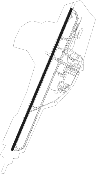
Runway info
| Runway 03 / 21 | ||
| length | 2903m (9524ft) | |
| bearing | 37° / 217° | |
| width | 45m (148ft) | |
| surface | asphalt | |
| displ threshold | 0m (0ft) / 210m (689ft) | |
Nearby beacons
| code | identifier | dist | bearing | frequency |
|---|---|---|---|---|
| NTS | NANTES ATLANTIQUE VOR/DME | 0.3 | 307° | 115.50 |
| GL | NANTES NDB | 7 | 218° | 369 |
| MT | SAINT NAZAIRE NDB | 20.7 | 292° | 398 |
| YN | LA ROCHE SUR YON LES AJONCS NDB | 31 | 146° | 334 |
| LP | CHOLET NDB | 31.4 | 92° | 357 |
| ANG | ANGERS VOR | 38.2 | 63° | 113 |
| REN | RENNES SAINT JACQUES VOR/DME | 55 | 352° | 109.25 |
| LA | LAVAL NDB | 61.9 | 49° | 401 |
| RL | LA ROCHELLE NDB | 62.5 | 153° | 322 |
Departure and arrival routes
| Transition altitude | 5000ft |
| SID end points | distance | outbound heading | |
|---|---|---|---|
| RW03 | |||
| LUGE3Q, LUGE3N | 46mi | 128° | |
| LUSO3Q, LUSO3N | 41mi | 159° | |
| NORM3Q | 25mi | 242° | |
| ERIG3N | 36mi | 249° | |
| ERBI3Q, ERBI3N | 33mi | 289° | |
| RIMO3Q, RIMO3N | 32mi | 301° | |
| BALN3N, BALN3Q | 28mi | 352° | |
| RW21 | |||
| LUGE3V, LUGE3S | 46mi | 128° | |
| LUSO3V, LUSO3S | 41mi | 159° | |
| NORM3V | 25mi | 242° | |
| ERIG3S | 36mi | 249° | |
| ERBI3V, ERBI3S | 33mi | 289° | |
| RIMO3S, RIMO3V | 32mi | 301° | |
| BALN3V, BALN3S | 28mi | 352° | |
| STAR starting points | distance | inbound heading | |
|---|---|---|---|
| RW03 | |||
| EPIX1C | 41.6 | 61° | |
| ERBI1C | 32.7 | 109° | |
| RIMO1C | 31.5 | 121° | |
| GODA1C | 32.4 | 144° | |
| VALA1C | 31.6 | 231° | |
| LUGE1C | 46.1 | 308° | |
| MANA1C | 62.9 | 325° | |
| LUSO1C | 40.8 | 339° | |
| RW21 | |||
| EPIX1D | 41.6 | 61° | |
| ERBI1D | 32.7 | 109° | |
| RIMO1D | 31.5 | 121° | |
| GODA1D | 32.4 | 144° | |
| VALA1D | 31.6 | 231° | |
| LUGE1D | 46.1 | 308° | |
| MANA1D | 62.9 | 325° | |
| LUSO1D | 40.8 | 339° | |
Instrument approach procedures
| runway | airway (heading) | route (dist, bearing) |
|---|---|---|
| RW03 | LAROK (339°) | LAROK DOGOV (20mi, 304°) 3000ft |
| RW03 | NEDAN (230°) | NEDAN RS701 (24mi, 242°) RS712 (14mi, 214°) 4000ft DOGOV (5mi, 109°) 3000ft |
| RW03 | NITEM (144°) | NITEM RS712 (28mi, 190°) 4000ft DOGOV (5mi, 109°) 3000ft |
| RW03 | NORMI (62°) | NORMI DOGOV (13mi, 83°) 3000ft |
| RNAV | DOGOV 3000ft FRS03 (5mi, 37°) 3000ft LFRS (10mi, 37°) 125ft RS710 (6mi, 37°) NITEM (15mi, 304°) 4000ft | |
| RW21 | LAROK (339°) | LAROK RS398 (25mi, 12°) RS400 (9mi, 12°) 3000ft IRS21 (5mi, 300°) 3000ft |
| RW21 | NEDAN (230°) | NEDAN IRS21 (9mi, 232°) 3000ft |
| RW21 | NITEM (144°) | NITEM RS404 (13mi, 99°) 3000ft IRS21 (5mi, 120°) 3000ft |
| RW21 | NORMI (62°) | NORMI RS402 (27mi, 51°) RS404 (11mi, 51°) 3000ft IRS21 (5mi, 120°) 3000ft |
| RNAV | IRS21 3000ft FRS21 (4mi, 231°) 3000ft MAPTS (8mi, 231°) 463ft RS410 (8mi, 231°) NORMI (18mi, 245°) 4000ft |
Holding patterns
| STAR name | hold at | type | turn | heading* | altitude | leg | speed limit |
|---|---|---|---|---|---|---|---|
| EPIX1C | NORMI | VHF | left | 231 (51)° | 7000ft - 14000ft | DME 6.0mi | 230 |
| EPIX1D | NORMI | VHF | left | 231 (51)° | 7000ft - 14000ft | DME 6.0mi | 230 |
| ERBI1C | NITEM | VHF | right | 334 (154)° | 7000ft - 14000ft | DME 6.0mi | 230 |
| ERBI1D | NITEM | VHF | right | 334 (154)° | 7000ft - 14000ft | DME 6.0mi | 230 |
| GODA1C | NITEM | VHF | right | 334 (154)° | 7000ft - 14000ft | DME 6.0mi | 230 |
| GODA1D | NITEM | VHF | right | 334 (154)° | 7000ft - 14000ft | DME 6.0mi | 230 |
| LUGE1C | LAROK | VHF | left | 165 (345)° | 7000ft - 14000ft | DME 6.0mi | 230 |
| LUGE1D | LAROK | VHF | left | 165 (345)° | 7000ft - 14000ft | DME 6.0mi | 230 |
| LUSO1C | LAROK | VHF | left | 165 (345)° | 7000ft - 14000ft | DME 6.0mi | 230 |
| LUSO1D | LAROK | VHF | left | 165 (345)° | 7000ft - 14000ft | DME 6.0mi | 230 |
| MANA1C | LAROK | VHF | left | 165 (345)° | 7000ft - 14000ft | DME 6.0mi | 230 |
| MANA1D | LAROK | VHF | left | 165 (345)° | 7000ft - 14000ft | DME 6.0mi | 230 |
| RIMO1C | NITEM | VHF | right | 334 (154)° | 7000ft - 14000ft | DME 6.0mi | 230 |
| RIMO1D | NITEM | VHF | right | 334 (154)° | 7000ft - 14000ft | DME 6.0mi | 230 |
| VALA1C | NEDAN | VHF | left | 40 (220)° | 7000ft - 14000ft | DME 6.0mi | 230 |
| VALA1D | NEDAN | VHF | left | 40 (220)° | 7000ft - 14000ft | DME 6.0mi | 230 |
| *) magnetic outbound (inbound) holding course | |||||||
Disclaimer
The information on this website is not for real aviation. Use this data with the X-Plane flight simulator only! Data taken with kind consent from X-Plane 12 source code and data files. Content is subject to change without notice.