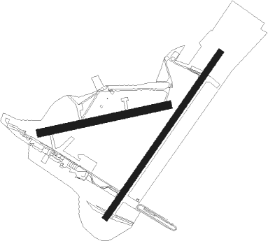
Monterblanc - Vannes Meucon
Airport details
| Country | France |
| State | Brittany |
| Region | LF |
| Airspace | Brest Ctr |
| Municipality | Monterblanc |
| Elevation | 437ft (133m) |
| Timezone | GMT +1 |
| Coordinates | 47.71925, -2.72338 |
| Magnetic var | |
| Type | land |
| Available since | X-Plane v10.40 |
| ICAO code | LFRV |
| IATA code | VNE |
| FAA code | n/a |
Communication
| Vannes Meucon AFIS | 122.600 |
| Vannes Meucon Twr | 122.600 |
| Vannes Meucon NANTES Approach | 122.800 |
| Vannes Meucon Dep | 122.600 |
Nearby Points of Interest:
Château de Beauregard
-Croix de cimetière de Saint-Avé
-Croix de chemin de Norbrat
-Manoir de Coëtdigo
-Château du Reste
-Croix Fitzgerald
-Immeuble Petit-Fers
-Prefecture hotel of Morbihan
-Hôtel Saint-Georges (Vannes)
-Tour du Connétable de Vannes
-Maison, 11 place des Lices (Vannes)
-Hôtel de Francheville
-Maison des Trois-Piliers
-Château de Trédion
-Gulf of Morbihan
-Puits de la Touche-Berthelot
-Croix Saint-Christophe
-Croix de cimetière de Larré
-Chêne du Pouldu
-Kervilio tide mill
-Mémorial de Sainte-Anne-d'Auray
-Croix de cimetière (Saint-Aubin)
-Monument du comte de Chambord
-Maison à la Ville au Lau
-Calvaire et ossuaire du cimetière de Guéhenno
Nearby beacons
| code | identifier | dist | bearing | frequency |
|---|---|---|---|---|
| VA | VANNES NDB | 3.9 | 51° | 342 |
| PNT | PONTIVY NDB | 20.1 | 348° | 377 |
| LOR | LORIENT LANN BIHOUE NDB | 29 | 274° | 359 |
| LOR | LORIENT LANN BIHOUE TACAN | 29.1 | 273° | 115.80 |
| MT | SAINT NAZAIRE NDB | 35.9 | 120° | 398 |
| REN | RENNES SAINT JACQUES VOR/DME | 44.7 | 70° | 109.25 |
| ARE | MONTS D'ARREE VOR | 51 | 305° | 112.50 |
| SB | SAINT BRIEUC NDB | 51 | 356° | 353 |
| DIN | DINARD PLEURTUIT SAINT MA VOR/DME | 58 | 36° | 114.30 |
Instrument approach procedures
| runway | airway (heading) | route (dist, bearing) |
|---|---|---|
| RW04 | RV402 (71°) | RV402 3500ft IRV04 (4mi, 119°) 2100ft |
| RW04 | RV404 (23°) | RV404 2100ft IRV04 (4mi, 299°) 2100ft |
| RW04 | VANEG (280°) | VANEG 2100ft RV404 (16mi, 253°) 2100ft IRV04 (4mi, 299°) 2100ft |
| RNAV | IRV04 2100ft FRV04 (4mi, 50°) 2100ft LFRV (5mi, 50°) 478ft RV410 (6mi, 50°) VANEG (11mi, 123°) 2100ft VANEG (turn) | |
| RW22 | RV202 (254°) | RV202 IRV22 (5mi, 299°) 2100ft |
| RW22 | RV204 (198°) | RV204 2100ft IRV22 (5mi, 119°) 2100ft |
| RW22 | VANEG (280°) | VANEG 2100ft RV202 (8mi, 342°) IRV22 (5mi, 299°) 2100ft |
| RNAV | IRV22 2100ft FRV22 (4mi, 231°) 2100ft LFRV (6mi, 230°) 487ft RV210 (1mi, 230°) VANEG (13mi, 97°) 2100ft VANEG (turn) |
Disclaimer
The information on this website is not for real aviation. Use this data with the X-Plane flight simulator only! Data taken with kind consent from X-Plane 12 source code and data files. Content is subject to change without notice.

