Montbéliard/courcelles - Monbeliard Courcelles
Airport details
| Country | France |
| State | Bourgogne-Franche-Comté |
| Region | LF |
| Airspace | Reims Ctr |
| Municipality | Courcelles-lès-Montbéliard |
| Elevation | 1041ft (317m) |
| Timezone | GMT +1 |
| Coordinates | 47.48667, 6.79139 |
| Magnetic var | |
| Type | land |
| Available since | X-Plane v10.40 |
| ICAO code | LFSM |
| IATA code | n/a |
| FAA code | n/a |
Communication
| Monbeliard Courcelles AFIS | 132.025 |
Nearby Points of Interest:
Habitat Fortifié de Bart
-Hôtel de la Croix d'Or
-Hôtel de Franquemont
-Ancien hôpital de Montbéliard
-Collège universitaire de Montbéliard
-Hôtel Bernard Fallot
-Maison Forstner
-Théâtre de Montbéliard
-Pierre à poissons
-Lion de Peugeot
-Hôtel Sponeck
-ibis styles montbeliard
-Ferme de la Souaberie
-La Bastille
-Fontaine de Sainte-Marie
-Église Saint-François-de-Sales (Beaucourt)
-Lavoir de Fêche-l'Église
-Lavoir de Saint-Dizier-l'Évêque
-Maison (18 rue Metzger, Belfort)
-Maison Boiteux
-Eglise de Saint-Hippolyte
-Couvent des Ursulines de Saint-Hippolyte
-Habitat fortifié du bois de la Miotte
-Wayside crosses in Offemont (1712)
-Maison Camboly
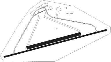
Runway info
Runway 8 / 26  | ||
| length | 1698m (5571ft) | |
| bearing | 83° / 263° | |
| width | 20m (66ft) | |
| surface | asphalt | |
| displ threshold | 405m (1329ft) / 412m (1352ft) | |
| Runway 8R / 26L | ||
| length | 856m (2808ft) | |
| bearing | 83° / 263° | |
| width | 50m (164ft) | |
| surface | grass | |
Nearby beacons
| code | identifier | dist | bearing | frequency |
|---|---|---|---|---|
| HR | HERICOURT NDB | 5.1 | 322° | 289 |
| MB | MONTBELIARD NDB | 5.4 | 82° | 330 |
| LUL | LUXEUIL VOR | 23.4 | 292° | 117.10 |
| LPS | LES EPLATURES NDB | 24.2 | 180° | 403 |
| LXI | LUXEUIL SAINT SAUVEUR TACAN | 25 | 304° | 108.20 |
| BSV | BESANCON NDB | 27.3 | 250° | 370 |
| BN | BASLE-MULHOUSE NDB | 29.7 | 76° | 353 |
| BLM | BASLE-MULHOUSE VOR/DME | 30 | 78° | 117.45 |
| BS | BASLE-MULHOUSE NDB | 30.7 | 83° | 376 |
| GRE | GRENCHEN VOR/DME | 31.3 | 116° | 115.45 |
| HOC | DME | 35.5 | 91° | 113.20 |
| HO | COLMAR-HOUSSEN NDB | 45.2 | 42° | 380 |
| FRI | FRIBOURG VOR/DME | 46.1 | 149° | 110.85 |
| LAP | PRAZ DME | 51 | 205° | 110.65 |
| EMT | EPINAL NDB | 56.2 | 325° | 419 |
| EPL | EPINAL MIRECOURT VOR | 57.9 | 319° | 113 |
Instrument approach procedures
| runway | airway (heading) | route (dist, bearing) |
|---|---|---|
| RW26 | HR (142°) | HR 5500ft SM404 (12mi, 83°) 3300ft ISM26 (5mi, 165°) 2900ft |
| RNAV | ISM26 2900ft FSM26 (5mi, 263°) 2900ft LFSM (6mi, 263°) 1086ft SM410 (7mi, 263°) HR (7mi, 47°) 5500ft HR (turn) 5500ft |
Disclaimer
The information on this website is not for real aviation. Use this data with the X-Plane flight simulator only! Data taken with kind consent from X-Plane 12 source code and data files. Content is subject to change without notice.