Pont Saint Vincent
Airport details
| Country | France |
| State | Grand Est |
| Region | LF |
| Airspace | Reims Ctr |
| Municipality | Maizières |
| Elevation | 1338ft (408m) |
| Timezone | GMT +1 |
| Coordinates | 48.60000, 6.05639 |
| Magnetic var | |
| Type | land |
| Available since | X-Plane v10.40 |
| ICAO code | LFSV |
| IATA code | n/a |
| FAA code | n/a |
Communication
| Pont Saint Vincent CTAF | 123.500 |
| Pont Saint Vincent Dep | 123.500 |
Nearby Points of Interest:
Bois l'Évêque dolmen
-villa Fournier-Defaut
-funiculaire de la Cure d'Air
-Tour Joffre Saint-Thiébaut
-L'Excelsior
-immeuble, 10 rue des Sœurs-Macarons
-maison Lecreulx
-Immeuble, 38 place de la Carrière
-papeterie de la Rochette
-City walls of Toul
-château de l'abbé de Bouzey
-Hôtel de Ville de Toul
-Synagogue of Toul
-Abbaye Saint-Léon de Toul
-Daum
-Maison Fruhinsholzs
-La Douëra
-grosse-maison de Villey-Saint-Étienne
-Cure d'air Trianon
-Tombeau de Hugues des Hazards
-site archéologique d'Essey-Nancy
-château de Lenoncourt
-Château de Vaudémont
-Monument Barrès
-Mairie-halle de Vicherey
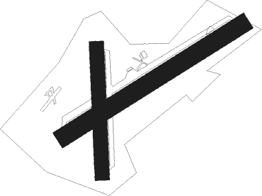
Runway info
Runway 06 / 24  | ||
| length | 1153m (3783ft) | |
| bearing | 71° / 251° | |
| width | 100m (328ft) | |
| surface | grass | |
| Runway 18 / 36 | ||
| length | 694m (2277ft) | |
| bearing | 183° / 3° | |
| width | 80m (262ft) | |
| surface | grass | |
| displ threshold | 78m (256ft) / 0m (0ft) | |
Nearby beacons
| code | identifier | dist | bearing | frequency |
|---|---|---|---|---|
| NAY | NANCY OCHEY TACAN | 4.2 | 261° | 116.80 |
| EMT | EPINAL NDB | 16.9 | 153° | 419 |
| EPL | EPINAL MIRECOURT VOR | 16.9 | 179° | 113 |
| LOU | LORRAINE NDB | 25.3 | 28° | 388 |
| GTQ | GROSTENQUIN VOR/DME | 34.9 | 60° | 111.25 |
| ETN | ETAIN NDB | 40.6 | 329° | 410 |
| MTZ | METZ NDB | 41 | 13° | 354 |
| LXI | LUXEUIL SAINT SAUVEUR TACAN | 50.5 | 160° | 108.20 |
| RLP | ROLAMPONT VOR/DME | 52.7 | 229° | 117.30 |
| LUL | LUXEUIL VOR | 55.5 | 165° | 117.10 |
| WLU | LUXEMBOURG NDB | 58.1 | 360° | 346 |
| MMD | MONTMEDY VOR | 60 | 310° | 109.40 |
Disclaimer
The information on this website is not for real aviation. Use this data with the X-Plane flight simulator only! Data taken with kind consent from X-Plane 12 source code and data files. Content is subject to change without notice.