Luxeuil/saint-sauveur - Luxeuil St Sauveur
Airport details
| Country | France |
| State | Bourgogne-Franche-Comté |
| Region | LF |
| Airspace | Reims Ctr |
| Municipality | Baudoncourt |
| Elevation | 912ft (278m) |
| Timezone | GMT +1 |
| Coordinates | 47.78722, 6.36500 |
| Magnetic var | |
| Type | land |
| Available since | X-Plane v10.40 |
| ICAO code | LFSX |
| IATA code | n/a |
| FAA code | n/a |
Communication
| Luxeuil St Sauveur LUXEUIL Tower | 122.100 |
| Luxeuil St Sauveur LUXEUIL Approach | 119.700 |
| Luxeuil St Sauveur LUXEUIL GCA Approach | 123.300 |
| Luxeuil St Sauveur LUXEUIL Approach | 129.925 |
Approach frequencies
| ILS-cat-I | RW11 | 108.1 | 18.00mi |
| 3° GS | RW11 | 108.1 | 18.00mi |
Nearby Points of Interest:
Luxeuil Abbey
-abbatial palace
-château de Saulx
-Puits communal d'Amblans
-Puits communal de Velotte
-Abbaye of Lure
-Lavoir Buriot
-Grande fontaine
-Hospice Marie-Richard
-Grenier chalot de Saint-Bresson
-Croix de cimetière de Montjustin-et-Velotte
-Gendarmerie de Faverney
-Halles de Faverney
-Mairie-école-justice de paix de Noroy-le-Bourg
-Caserne de Faverney
-Thermes Napoléon de Plombières-les-Bains
-Bain National de Plombières-les-Bains
-Coal mine Sainte Marie
-Filature de Ronchamp
-Collège de Marteroy
-Protestant temple of Vesoul
-hôtel de Mongenet
-Hôtel de Magnoncourt (Vesoul)
-Palais de justice de Vesoul
-hôtel Pétremand
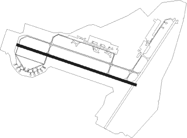
Runway info
| Runway 11 / 29 | ||
| length | 2428m (7966ft) | |
| bearing | 106° / 286° | |
| width | 45m (148ft) | |
| surface | concrete | |
| blast zone | 255m (837ft) / 255m (837ft) | |
Nearby beacons
| code | identifier | dist | bearing | frequency |
|---|---|---|---|---|
| LXI | LUXEUIL SAINT SAUVEUR TACAN | 0.4 | 243° | 108.20 |
| LUL | LUXEUIL VOR | 6.5 | 215° | 117.10 |
| HR | HERICOURT NDB | 20.1 | 122° | 289 |
| MB | MONTBELIARD NDB | 28.2 | 117° | 330 |
| BSV | BESANCON NDB | 31.9 | 197° | 370 |
| EMT | EPINAL NDB | 33.4 | 343° | 419 |
| EPL | EPINAL MIRECOURT VOR | 34.1 | 330° | 113 |
| LPS | LES EPLATURES NDB | 45.7 | 149° | 403 |
| NAY | NANCY OCHEY TACAN | 50.6 | 333° | 116.80 |
| PHG | PHALSBOURG NDB | 67.6 | 40° | 424 |
Instrument approach procedures
| runway | airway (heading) | route (dist, bearing) |
|---|---|---|
| RW11 | SX412 (92°) | SX412 4000ft ISX11 (6mi, 54°) 2900ft |
| RW11 | SX413 (105°) | SX413 3200ft ISX11 (6mi, 106°) 2900ft |
| RW11 | SX414 (121°) | SX414 4500ft ISX11 (6mi, 184°) 2900ft |
| RNAV | ISX11 2900ft FSX11 (6mi, 106°) 2900ft LFSX (7mi, 105°) 910ft SX417 (3mi, 110°) SX414 (19mi, 300°) 2900ft | |
| RW29 | SX421 (72°) | SX421 4000ft SX422 (7mi, 122°) 2600ft SX423 (4mi, 104°) 2600ft SX424 (4mi, 76°) ISX29 (4mi, 39°) 2600ft |
| RNAV | ISX29 2600ft FSX29 (4mi, 290°) 2600ft MAP29 (5mi, 290°) 1068ft SX427 (5mi, 290°) 2600ft SX421 (6mi, 219°) 2600ft |
Disclaimer
The information on this website is not for real aviation. Use this data with the X-Plane flight simulator only! Data taken with kind consent from X-Plane 12 source code and data files. Content is subject to change without notice.