Amberieu En Bugey - Amberieu
Airport details
| Country | France |
| State | Auvergne-Rhône-Alpes |
| Region | LF |
| Airspace | Marseille Ctr |
| Municipality | Ambérieu-en-Bugey |
| Elevation | 823ft (251m) |
| Timezone | GMT +1 |
| Coordinates | 45.97985, 5.33782 |
| Magnetic var | |
| Type | land |
| Available since | X-Plane v11.50 |
| ICAO code | LFXA |
| IATA code | n/a |
| FAA code | n/a |
Communication
| Amberieu AMBERIEU Tower | 122.100 |
| Amberieu LYON Approach | 125.800 |
Nearby Points of Interest:
Centre nautique de Lagnieu
-Fresco of Saint Christopher of Saint-Sorlin-en-Bugey
-Grotte de la Colombière
-Maison Bolli
-Maison Mingat
-Grenier à sel
-Porte d'En-Bas
-Écurie Thimon
-Maison Messimy
-Maison Jean Escoffier
-Maison du Sergent de Justice
-Moulin à farine de Cerdon
-Maison Nicolas
-Écuries Vernay
-Pont de Serrières-sur-Ain
-Aqueduc romain de Briord
-Habitat du premier âge féodal de Jasseron
-Hôtel-Dieu de Bourg-en-Bresse
-Eglise Saint-Martin
-Immeuble, 10 rue Victor-Basch (Bourg-en-Bresse)
-Bourg-en-Bresse city hall
-Grotte de Corveissiat
-Gare de La Cluse
-Plateau de Retord
-Lac de Cerin
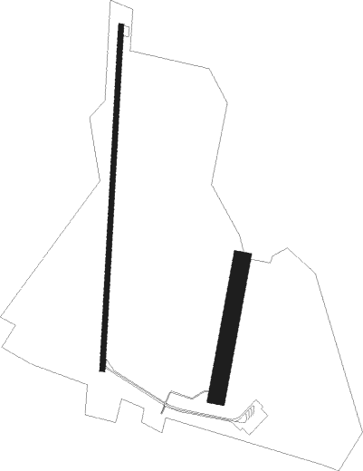
Runway info
Runway 01L / 19R  | ||
| length | 1995m (6545ft) | |
| bearing | 11° / 191° | |
| width | 30m (98ft) | |
| surface | asphalt | |
| displ threshold | 0m (0ft) / 202m (663ft) | |
| Runway 01R / 19L | ||
| length | 797m (2615ft) | |
| bearing | 21° / 201° | |
| width | 100m (328ft) | |
| surface | grass | |
| displ threshold | 0m (0ft) / 130m (427ft) | |
Nearby beacons
| code | identifier | dist | bearing | frequency |
|---|---|---|---|---|
| LSE | LYON SAINT EXUPERY VOR/DME | 17.4 | 227° | 114.75 |
| CBY | CHAMBERY VOR/DME | 18.4 | 103° | 115.40 |
| BR | LYON-BRON NDB | 26.1 | 223° | 388 |
| AT | ANNECY NDB | 29.3 | 100° | 384 |
| LTP | LA TOUR DU PIN VOR/DME | 29.7 | 168° | 115.55 |
| PAS | PASSEIRY VOR/DME | 29.7 | 74° | 116.60 |
| VNE | VIENNE REVENTIN VOR | 31.7 | 227° | 108.20 |
| CH | CHAMBERY NDB | 32.6 | 125° | 346 |
| GVA | GENEVA VOR/DME | 36.9 | 71° | 115.75 |
| EG | GRENOBLE NDB | 37 | 174° | 397 |
| WS | GRENOBLE NDB | 37.8 | 197° | 291 |
| GLA | GLAND NDB | 45.6 | 65° | 375 |
| CC | CHAMPFORGEUIL NDB | 49 | 326° | 391 |
| DO | DOLE NDB | 60 | 358° | 309 |
Disclaimer
The information on this website is not for real aviation. Use this data with the X-Plane flight simulator only! Data taken with kind consent from X-Plane 12 source code and data files. Content is subject to change without notice.