Gyöngyös - Gyöngyös - Pipishegy
Airport details
| Country | Hungary |
| State | Heves |
| Region | LH |
| Airspace | Budapest Ctr |
| Municipality | Gyöngyös |
| Elevation | 1146ft (349m) |
| Timezone | GMT +1 |
| Coordinates | 47.81439, 19.97682 |
| Magnetic var | |
| Type | land |
| Available since | X-Plane v10.40 |
| ICAO code | LHGY |
| IATA code | n/a |
| FAA code | n/a |
Communication
| Gyöngyös - Pipishegy info | 121.410 |
Nearby Points of Interest:
Sár Hill
-Mátra
-Pusztafogacs
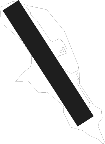
Runway info
| Runway 15 / 33 | ||
| length | 761m (2497ft) | |
| bearing | 141° / 321° | |
| width | 120m (394ft) | |
| surface | grass | |
Nearby beacons
| code | identifier | dist | bearing | frequency |
|---|---|---|---|---|
| TPS | TAPIOSAP VOR/DME | 28.8 | 239° | 115.90 |
| BUD | BUDAPEST VOR/DME | 36.6 | 243° | 117.30 |
| MNR | MONOR VOR/DME | 36.9 | 230° | 112.50 |
| OA | SZOLNOK NDB | 40.7 | 157° | 282 |
| O | SZOLNOK NDB | 42 | 158° | 422 |
| A | SZOLNOK NDB | 43.7 | 161° | 422 |
| AO | SZOLNOK NDB | 45 | 162° | 282 |
| SLC | SLIAC VOR/DME | 51.6 | 307° | 114 |
| NT | KECSKEMET NDB | 53.5 | 198° | 313 |
| N | KECSKEMET NDB | 54.1 | 196° | 440 |
| KET | KECSKEMET VORTAC | 54.2 | 196° | 114.15 |
| T | KECSKEMET NDB | 55.1 | 193° | 440 |
| TN | KECSKEMET NDB | 55.8 | 190° | 313 |
Disclaimer
The information on this website is not for real aviation. Use this data with the X-Plane flight simulator only! Data taken with kind consent from X-Plane 12 source code and data files. Content is subject to change without notice.