Budapest - Kiskunlacháza
Airport details
| Country | Hungary |
| State | Pest |
| Region | |
| Airspace | Budapest Ctr |
| Municipality | Kiskunlacháza |
| Elevation | 317ft (97m) |
| Timezone | GMT +1 |
| Coordinates | 47.17988, 19.07050 |
| Magnetic var | |
| Type | land |
| Available since | X-Plane v10.40 |
| ICAO code | LHKK |
| IATA code | n/a |
| FAA code | n/a |
Communication
| Kiskunlacháza Lacháza INFO | 124.025 |
Nearby Points of Interest:
Upper Kiskunság alkaline steppes
-Ócsa Protected Landscape Area
-Hungária Mill
-Semmelweis University Józsefvárosi Clinical Complex
-Saint Catherine of Alexandria Church, Tabán
-Hungarian Institute of Geology and Geophysics
-Béla király 20, Frivaldszky Villa
-Kútvölgyi Úti Oktatókórház
-Jewish Chevra Kadisa Home of Elderly
-Bécsi út, 56
-Velencei madárrezervátum
-Sárvíz-völgye Tájvédelmi Körzet
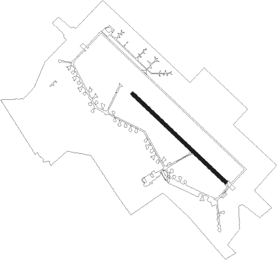
Runway info
| Runway 15 / 33 | ||
| length | 1584m (5197ft) | |
| bearing | 127° / 307° | |
| width | 45m (148ft) | |
| surface | concrete | |
| displ threshold | 396m (1299ft) / 394m (1293ft) | |
| blast zone | 255m (837ft) / 85m (279ft) | |
Nearby beacons
| code | identifier | dist | bearing | frequency |
|---|---|---|---|---|
| PTB | PUSZTASZABOLCS VOR/DME | 13.5 | 265° | 117.10 |
| MNR | MONOR VOR/DME | 16.5 | 65° | 112.50 |
| BUD | BUDAPEST VOR/DME | 17.8 | 33° | 117.30 |
| TPS | TAPIOSAP VOR/DME | 24.2 | 50° | 115.90 |
| NT | KECSKEMET NDB | 28.9 | 111° | 313 |
| N | KECSKEMET NDB | 30.7 | 111° | 440 |
| KET | KECSKEMET VORTAC | 30.8 | 111° | 114.15 |
| T | KECSKEMET NDB | 33.1 | 111° | 440 |
| TN | KECSKEMET NDB | 34.7 | 111° | 313 |
| BUG | BUGAC VOR/DME | 39.2 | 129° | 113.40 |
| SVR | SAGVAR VOR/DME | 44.3 | 250° | 117.70 |
Disclaimer
The information on this website is not for real aviation. Use this data with the X-Plane flight simulator only! Data taken with kind consent from X-Plane 12 source code and data files. Content is subject to change without notice.