Szeged
Airport details
| Country | Hungary |
| State | Csongrád |
| Region | LH |
| Airspace | Budapest Ctr |
| Municipality | Szeged |
| Elevation | 262ft (80m) |
| Timezone | GMT +1 |
| Coordinates | 46.25083, 20.08917 |
| Magnetic var | |
| Type | land |
| Available since | X-Plane v10.40 |
| ICAO code | LHUD |
| IATA code | n/a |
| FAA code | n/a |
Communication
| Szeged UNICOM | 122.800 |
| Szeged BUD INFO (East) | 133.000 |
Nearby Points of Interest:
Pusztaszeri Tájvédelmi Körzet
-Mártélyi Tájvédelmi Körzet
-Flood protection wall, Hódmezővásárhely
-Ludaš Lake
-Catholic church in Čoka
-site de la bataille de Senta
-Kapela Sv. Roka
-Church of St. Nicholas in Nădlac
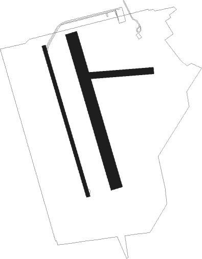
Runway info
Runway 16L / 34R  | ||
| length | 1157m (3796ft) | |
| bearing | 163° / 343° | |
| width | 90m (295ft) | |
| surface | grass | |
| Runway 09 / 27 | ||
| length | 505m (1657ft) | |
| bearing | 90° / 270° | |
| width | 50m (164ft) | |
| surface | grass | |
| Runway 16R / 34L | ||
| length | 1186m (3891ft) | |
| bearing | 163° / 343° | |
| width | 30m (98ft) | |
| surface | asphalt | |
Nearby beacons
| code | identifier | dist | bearing | frequency |
|---|---|---|---|---|
| SEG | SZEGED NDB | 0.6 | 180° | 456 |
| BUG | BUGAC VOR/DME | 30.6 | 316° | 113.40 |
| TN | KECSKEMET NDB | 40.2 | 336° | 313 |
| T | KECSKEMET NDB | 41.4 | 334° | 440 |
| KET | KECSKEMET VORTAC | 43.2 | 332° | 114.15 |
| N | KECSKEMET NDB | 43.4 | 332° | 440 |
| NT | KECSKEMET NDB | 44.8 | 330° | 313 |
| CNI | DME | 46.8 | 123° | 115.60 |
| AO | SZOLNOK NDB | 50.1 | 8° | 282 |
| A | SZOLNOK NDB | 51.6 | 9° | 422 |
| BKS | BEKES VOR/DME | 52.3 | 61° | 115.80 |
| O | SZOLNOK NDB | 53.6 | 10° | 422 |
| OA | SZOLNOK NDB | 55.2 | 11° | 282 |
| PV | PETROVARADIN NDB | 60.3 | 196° | 300 |
Disclaimer
The information on this website is not for real aviation. Use this data with the X-Plane flight simulator only! Data taken with kind consent from X-Plane 12 source code and data files. Content is subject to change without notice.