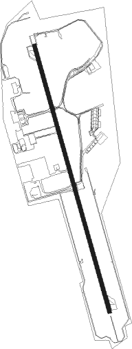
Grottaglie - Taranto Grottaglie
Airport details
| Country | Italy |
| State | Apulia |
| Region | LI |
| Airspace | Brindisi Ctr |
| Municipality | Grottaglie |
| Elevation | 213ft (65m) |
| Timezone | GMT +1 |
| Coordinates | 40.52088, 17.39860 |
| Magnetic var | |
| Type | land |
| Available since | X-Plane v10.40 |
| ICAO code | LIBG |
| IATA code | TAR |
| FAA code | n/a |
Communication
| TARANTO Grottaglie Grottaglie Tower | 118.700 |
Approach frequencies
| ILS-cat-I | RW35 | 108.35 | 18.00mi |
| 3° GS | RW35 | 108.35 | 18.00mi |
Nearby Points of Interest:
Messapians Documentation Centre
-The Trulli of Alberobello
-chiesa di San Giovanni Battista
-Punta Torre Canne lighthouse
-Museo diocesano Giovanni Tarantini
-Conversano Castle
Nearby beacons
| code | identifier | dist | bearing | frequency |
|---|---|---|---|---|
| TAG | TARANTO VOR/DME | 0.7 | 140° | 110.20 |
| GRT | GROTTAGLIE TACAN | 1.9 | 159° | 116.80 |
| GRT | GROTTAGLIE NDB | 4.6 | 163° | 331 |
| BCS | CASALE (BRINDISI) VOR/DME | 26.5 | 76° | 113.55 |
| GDC | GIOIA DEL COLLE VOR/DME | 26.7 | 298° | 113.35 |
| BRD | BRINDISI VORTAC | 28 | 82° | 113.20 |
| GIO | GIOIA TACAN | 28.2 | 299° | 117.80 |
| LCC | LECCE VORTAC | 37.3 | 110° | 112.80 |
| BAR | BARI VOR/DME | 46.9 | 315° | 116.40 |
| BPL | PALESE (BARI) NDB | 48.7 | 309° | 401 |
Departure and arrival routes
| Transition altitude | 5000ft |
| SID end points | distance | outbound heading | |
|---|---|---|---|
| RW17 | |||
| ROBO5Q | 12mi | 21° | |
| KAPO5D, KAPO5Q | 28mi | 82° | |
| RW35 | |||
| ROBO5P | 12mi | 21° | |
| KAPO5F, KAPO5P | 28mi | 82° | |
| STAR starting points | distance | inbound heading | |
|---|---|---|---|
| ALL | |||
| ROBO1M, ROBO1N, ROBO1L | 11.7 | 201° | |
| KAPO1L, KAPO1M, KAPO1N | 26.5 | 256° | |
| KAPO1A, KAPO1E, KAPO1C | 28.0 | 262° | |
Instrument approach procedures
| runway | airway (heading) | route (dist, bearing) |
|---|---|---|
| RW35-Y | TAG (320°) | TAG 5000ft ATTEC (3mi, 118°) 3000ft BG516 (4mi, 118°) 3000ft BG512 (4mi, 185°) 2500ft BG708 (4mi, 267°) 2200ft |
| RNAV | BG708 2200ft BG505 (4mi, 345°) 1800ft LIBG (6mi, 343°) 260ft BG536 (2mi, 351°) BG527 (5mi, 229°) 2200ft ATTEC (7mi, 95°) 3000ft ATTEC (turn) 3000ft | |
| RW35-Z | TAG (320°) | TAG 5000ft ATTEC (3mi, 118°) 3000ft BG516 (4mi, 118°) 3000ft BG512 (4mi, 185°) 2500ft BG508 (3mi, 273°) 2200ft |
| RNAV | BG508 2200ft BG505 (3mi, 328°) 1800ft BG501 (4mi, 345°) 643ft BG536 (5mi, 345°) BG527 (5mi, 229°) 2200ft ATTEC (7mi, 95°) 3000ft ATTEC (turn) 3000ft |
Holding patterns
| STAR name | hold at | type | turn | heading* | altitude | leg | speed limit |
|---|---|---|---|---|---|---|---|
| KAPO1A | GRT | FIX | left | 345 (165)° | > 3000ft | 1.0min timed | 200 |
| KAPO1C | TAG | NDB | left | 10 (190)° | > 5000ft | 1.0min timed | 200 |
| KAPO1E | MASAX | VHF | right | 166 (346)° | > 3000ft | DME 4.0mi | 200 |
| KAPO1E | TAG | NDB | left | 10 (190)° | > 5000ft | 1.0min timed | 200 |
| KAPO1L | MASAX | VHF | right | 166 (346)° | > 3000ft | DME 4.0mi | 200 |
| KAPO1L | TAG | NDB | left | 10 (190)° | > 5000ft | 1.0min timed | 200 |
| KAPO1M | TAG | NDB | left | 10 (190)° | > 5000ft | 1.0min timed | 200 |
| KAPO1N | GRT | FIX | left | 345 (165)° | > 3000ft | 1.0min timed | 200 |
| ROBO1L | MASAX | VHF | right | 166 (346)° | > 3000ft | DME 4.0mi | 200 |
| ROBO1L | TAG | NDB | left | 10 (190)° | > 5000ft | 1.0min timed | 200 |
| ROBO1M | TAG | NDB | left | 10 (190)° | > 5000ft | 1.0min timed | 200 |
| ROBO1N | GRT | FIX | left | 345 (165)° | > 3000ft | 1.0min timed | 200 |
| *) magnetic outbound (inbound) holding course | |||||||
Disclaimer
The information on this website is not for real aviation. Use this data with the X-Plane flight simulator only! Data taken with kind consent from X-Plane 12 source code and data files. Content is subject to change without notice.
