Reggio Calabria
Airport details
| Country | Italy |
| State | Calabria |
| Region | LI |
| Airspace | Rome Ctr |
| Municipality | Reggio Calabria |
| Elevation | 96ft (29m) |
| Timezone | GMT +1 |
| Coordinates | 38.07074, 15.65684 |
| Magnetic var | |
| Type | land |
| Available since | X-Plane v10.40 |
| ICAO code | LICR |
| IATA code | REG |
| FAA code | n/a |
Communication
| Reggio Calabria Tower | 118.250 |
| Reggio Calabria Approach | 120.275 |
Approach frequencies
| LOC | RW33 | 109.3 | 18.00mi |
Nearby Points of Interest:
Palazzo Zanca
-Palazzo della cultura
-Basilica santuario di Maria Santissima dei Poveri
-Civic museum of Castroreale
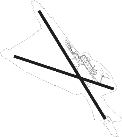
Runway info
Runway 15 / 33  | ||
| length | 2063m (6768ft) | |
| bearing | 147° / 327° | |
| width | 45m (148ft) | |
| surface | asphalt | |
| displ threshold | 251m (823ft) / 111m (364ft) | |
| blast zone | 64m (210ft) / 0m (0ft) | |
| Runway 11 / 29 | ||
| length | 1702m (5584ft) | |
| bearing | 108° / 288° | |
| width | 45m (148ft) | |
| surface | asphalt | |
| blast zone | 103m (338ft) / 47m (154ft) | |
Nearby beacons
| code | identifier | dist | bearing | frequency |
|---|---|---|---|---|
| RCA | REGGIO CALABRIA VOR/DME | 0.6 | 297° | 111 |
| RCA | REGGIO CALABRIA NDB | 3.4 | 187° | 325 |
| CTF | FONTANAROSSA (CATANIA) VOR/DME | 46 | 224° | 116.25 |
| CTF | CATANIA NDB | 46.1 | 224° | 407 |
| SIG | SIGONELLA NDB | 51.9 | 225° | 412 |
| SIG | SIGONELLA TACAN | 52 | 225° | 111.60 |
| CDC | CARAFFA VORTAC | 53 | 46° | 117.30 |
| NSY | SIGONELLA TACAN | 53.2 | 228° | 111.20 |
| LMT | LAMEZIA VOR/DME | 57.6 | 36° | 112.50 |
Departure and arrival routes
| Transition altitude | 7000ft |
| SID end points | distance | outbound heading | |
|---|---|---|---|
| RW15 | |||
| CDC5X, CDC5Y, CDC6A, CDC6B, CDC5H, CDC5F | 53mi | 46° | |
| BERM5H, BERM5F, BERM5B, BERM5A | 37mi | 208° | |
| INDA5F, INDA5B | 39mi | 213° | |
| SOPO5H, SOPO5F | 17mi | 241° | |
| PIGE8B, PIGE7D, PIGE7C, PIGE7A, PIGE6N, PIGE6M, PIGE6J, PIGE6H | 31mi | 332° | |
| RW29 | |||
| CDC5X, CDC5Y, CDC6A, CDC6B, CDC5J, CDC5E | 53mi | 46° | |
| BERM5G, BERM5E, BERM5B, BERM5A | 37mi | 208° | |
| INDA5E, INDA5B | 39mi | 213° | |
| SOPO5G, SOPO5E | 17mi | 241° | |
| PIGE8B, PIGE7D, PIGE7C, PIGE7A, PIGE6L, PIGE6K, PIGE6G, PIGE6F | 31mi | 332° | |
| RW33 | |||
| CDC5E, CDC5X, CDC5Y, CDC6A, CDC6B, CDC5J | 53mi | 46° | |
| BERM5G, BERM5E, BERM5B, BERM5A | 37mi | 208° | |
| INDA5E, INDA5B | 39mi | 213° | |
| SOPO5G, SOPO5E | 17mi | 241° | |
| PIGE8B, PIGE7D, PIGE7C, PIGE7A, PIGE6P, PIGE6L, PIGE6K, PIGE6G | 31mi | 332° | |
| STAR starting points | distance | inbound heading | |
|---|---|---|---|
| ALL | |||
| BERM1A, BERM1B | 36.8 | 28° | |
| PIGE1X, PIGE1B, PIGE1A | 31.0 | 152° | |
| PERO1B, PERO1X, PERO1A | 34.8 | 196° | |
| GIME1X, GIME1A | 30.0 | 225° | |
Instrument approach procedures
| runway | airway (heading) | route (dist, bearing) |
|---|---|---|
| RW15-Y | LONDA (151°) | LONDA 4000ft CR711 (3mi, 174°) 3200ft |
| RNAV | CR711 3200ft CR712 (3mi, 147°) 2700ft LICR (8mi, 145°) 133ft DEDRA (13mi, 199°) 3000ft DEDRA (turn) 3000ft | |
| RW15-Z | LONDA (151°) | LONDA 4000ft CR711 (3mi, 174°) 3200ft |
| RNAV | CR711 3200ft CR712 (3mi, 147°) 2700ft CR713 (6mi, 147°) 484ft DEDRA (15mi, 193°) 3000ft DEDRA (turn) 3000ft | |
| RWNVG | DEDRA (19°) | DEDRA 3000ft CR704 (3mi, 27°) 3000ft |
| RWNVG | EKTEM (34°) | EKTEM 4000ft CR704 (3mi, 84°) 3000ft |
| RWNVG | LONDA (151°) | LONDA 6500ft CR401 (9mi, 174°) 4000ft CR703 (9mi, 185°) 4000ft EKTEM (5mi, 185°) 4000ft CR704 (3mi, 84°) 3000ft |
| RWNVG | RCA (117°) | RCA 6500ft CR703 (8mi, 225°) 4000ft EKTEM (5mi, 185°) 4000ft CR704 (3mi, 84°) 3000ft |
| RNAV | CR704 3000ft CR702 (3mi, 23°) 2700ft CR723 (3mi, 22°) 1630ft EKTEM (8mi, 226°) 4000ft EKTEM (turn) 4000ft |
Holding patterns
| STAR name | hold at | type | turn | heading* | altitude | leg | speed limit |
|---|---|---|---|---|---|---|---|
| BERM1B | DEDRA | VHF | right | 197 (17)° | 3000ft - 6000ft | DME 4.0mi | 210 |
| BERM1B | RCA | NDB | left | 188 (8)° | > 6000ft | 1.0min timed | ICAO rules |
| GIME1X | LONDA | VHF | left | 336 (156)° | > 4000ft | DME 4.0mi | ICAO rules |
| PERO1B | RCA | NDB | left | 188 (8)° | > 6000ft | 1.0min timed | ICAO rules |
| PERO1X | LONDA | VHF | left | 336 (156)° | > 4000ft | DME 4.0mi | ICAO rules |
| PIGE1A | LONDA | VHF | left | 336 (156)° | > 4000ft | DME 4.0mi | ICAO rules |
| PIGE1B | RCA | NDB | left | 188 (8)° | > 6000ft | 1.0min timed | ICAO rules |
| PIGE1X | LONDA | VHF | left | 336 (156)° | > 4000ft | DME 4.0mi | ICAO rules |
| *) magnetic outbound (inbound) holding course | |||||||
Disclaimer
The information on this website is not for real aviation. Use this data with the X-Plane flight simulator only! Data taken with kind consent from X-Plane 12 source code and data files. Content is subject to change without notice.