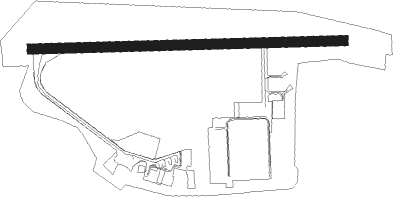
Albenga
Airport details
| Country | Italy |
| State | Liguria |
| Region | LI |
| Airspace | Milan Ctr |
| Municipality | Villanova d'Albenga |
| Elevation | 147ft (45m) |
| Timezone | GMT +1 |
| Coordinates | 44.04844, 8.13304 |
| Magnetic var | |
| Type | land |
| Available since | X-Plane v10.30 |
| ICAO code | LIMG |
| IATA code | ALL |
| FAA code | n/a |
Communication
| Albenga INFO | 123.850 |
Approach frequencies
| LOC | RW27 | 108.9 | 18.00mi |
Nearby beacons
| code | identifier | dist | bearing | frequency |
|---|---|---|---|---|
| ALB | ALBENGA VOR/DME | 0.2 | 267° | 116.95 |
| ABN | ALBENGA NDB | 3.8 | 85° | 420 |
| SES | SESTRI (GENOA) VOR/DME | 37 | 62° | 108.60 |
| LEV | CUNEO NDB | 37.1 | 314° | 371 |
| NIZ | NICE COTE D'AZUR VOR/DME | 41.5 | 252° | 112.40 |
| AZR | NICE VOR/DME | 45.7 | 247° | 109.65 |
| GEN | GENOA NDB | 46.6 | 68° | 318 |
| CGS | CAGNES-SUR-MER VOR/DME | 49.1 | 248° | 109.20 |
| TOP | TORINO NDB | 53.9 | 343° | 392 |
| VOG | VOGHERA NDB | 65.6 | 43° | 333 |
Departure and arrival routes
| Transition altitude | 7000ft |
| SID end points | distance | outbound heading | |
|---|---|---|---|
| RW09 | |||
| LAGE6T | 26mi | 47° | |
| UNIT6T | 39mi | 97° | |
| STAR starting points | distance | inbound heading | |
|---|---|---|---|
| ALL | |||
| USAN1L | 26.1 | 53° | |
| IXIT2L, IXIT2M | 29.3 | 263° | |
| UNIT3L, UNIT3M | 39.0 | 277° | |
Holding patterns
| STAR name | hold at | type | turn | heading* | altitude | leg | speed limit |
|---|---|---|---|---|---|---|---|
| GEN3L | ABN | FIX | right | 224 (44)° | > 6000ft | 1.0min timed | 190 |
| IXIT2L | ABN | FIX | right | 224 (44)° | > 6000ft | 1.0min timed | 190 |
| IXIT2L | BERAB | VHF | right | 88 (268)° | > 4000ft | DME 4.0mi | 210 |
| IXIT2M | BERAB | VHF | right | 88 (268)° | > 4000ft | DME 4.0mi | 210 |
| UNIT3L | ABN | FIX | right | 224 (44)° | > 6000ft | 1.0min timed | 190 |
| UNIT3L | BERAB | VHF | right | 88 (268)° | > 4000ft | DME 4.0mi | 210 |
| UNIT3M | BERAB | VHF | right | 88 (268)° | > 4000ft | DME 4.0mi | 210 |
| USAN1L | ABN | FIX | right | 224 (44)° | > 6000ft | 1.0min timed | 190 |
| *) magnetic outbound (inbound) holding course | |||||||
Disclaimer
The information on this website is not for real aviation. Use this data with the X-Plane flight simulator only! Data taken with kind consent from X-Plane 12 source code and data files. Content is subject to change without notice.
