Forlì (fc) - Forli
Airport details
| Country | Italy |
| State | Emilia-Romagna |
| Region | LI |
| Airspace | Milan Ctr |
| Municipality | Forlì |
| Elevation | 97ft (30m) |
| Timezone | GMT +1 |
| Coordinates | 44.19372, 12.07841 |
| Magnetic var | |
| Type | land |
| Available since | X-Plane v10.40 |
| ICAO code | LIPK |
| IATA code | FRL |
| FAA code | n/a |
Communication
| Forli Forlì Tower | 119.750 |
| Forli Bologna Approach | 133.750 |
| Forli Romagna Radar | 118.150 |
| Forli Bologna Approach | 118.150 |
Approach frequencies
| ILS-cat-I | RW12 | 109.7 | 18.00mi |
| 3.3° GS | RW12 | 109.7 | 18.00mi |
Nearby Points of Interest:
former aeronautical college palace
-former G.I.L. palace
-Palazzo del Merenda
-Palazzo dei Signori della Missione
-Palazzo Paulucci de Calboli
-Palazzo del Podestà
-city hall
-Monte di Pietà
-Palazzo Albicini
-Palazzo Merlini
-Palazzo Gaddi
-Palazzo Sassi Masini (Forlì)
-Palazzo Manzoni
-Villa Saffi
-Santa Maria in Acquedotto
-Palazzo Ordelaffi
-Teatro Gian Andrea Dragoni
-Palazzo dei Commissari o del Pretorio
-Chiesa dei Santi Nicolò e Francesco
-Villa Silvia
-Pieve di San Pietro in Trento
-Ponte San Martino
-Porta Fiume
-Palace Romagnoli
-Palazzo Comunale (Cesena)
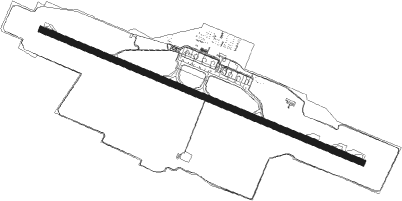
Runway info
| Runway 12 / 30 | ||
| length | 2559m (8396ft) | |
| bearing | 110° / 290° | |
| width | 45m (148ft) | |
| surface | asphalt | |
| displ threshold | 0m (0ft) / 147m (482ft) | |
| blast zone | 0m (0ft) / 8m (26ft) | |
Nearby beacons
| code | identifier | dist | bearing | frequency |
|---|---|---|---|---|
| FOL | FORLI VOR/DME | 0.4 | 270° | 115.75 |
| CEV | CERVIA TACAN | 12 | 87° | 113.60 |
| RIM | RIMINI NDB | 19.6 | 105° | 335 |
| RIM | RIMINI VORTAC | 25.5 | 108° | 116.20 |
| RMN | (RIMINI) DME | 25.6 | 108° | 108.80 |
| BOA | BOLOGNA VOR/DME | 39.6 | 294° | 117.10 |
| PRT | PERETOLA (FLORENCE) VOR/DME | 44.3 | 246° | 112.50 |
| CHI | CHIOGGIA NDB | 53.4 | 13° | 408 |
Departure and arrival routes
| Transition altitude | 6000ft |
| SID end points | distance | outbound heading | |
|---|---|---|---|
| RW12 | |||
| AMLO6Q | 35mi | 80° | |
| ASDO6Q | 28mi | 142° | |
| LUMA7Q | 42mi | 323° | |
| GIPU6Q | 24mi | 344° | |
| RW30 | |||
| AMLO6R | 35mi | 80° | |
| ASDO6R | 28mi | 142° | |
| LUMA7R | 42mi | 323° | |
| STAR starting points | distance | inbound heading | |
|---|---|---|---|
| ALL | |||
| LUMA3Q, LUMA3R | 42.2 | 143° | |
| GIPU2Q, GIPU2R | 24.1 | 164° | |
| ASDO2Q, ASDO2R | 28.2 | 322° | |
Holding patterns
| STAR name | hold at | type | turn | heading* | altitude | leg | speed limit |
|---|---|---|---|---|---|---|---|
| ASDO2Q | FOL | NDB | left | 279 (99)° | > 3000ft | 1.0min timed | 185 |
| ASDO2R | RIMED | VHF | right | 299 (119)° | > 3000ft | DME 4.5mi | 220 |
| BOA2Q | FOL | NDB | left | 279 (99)° | > 3000ft | 1.0min timed | 185 |
| GIPU2Q | FOL | NDB | left | 279 (99)° | > 3000ft | 1.0min timed | 185 |
| LUMA3Q | FOL | NDB | left | 279 (99)° | > 3000ft | 1.0min timed | 185 |
| *) magnetic outbound (inbound) holding course | |||||||
Disclaimer
The information on this website is not for real aviation. Use this data with the X-Plane flight simulator only! Data taken with kind consent from X-Plane 12 source code and data files. Content is subject to change without notice.