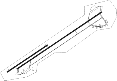
Caserta - Grazzanise
Airport details
| Country | Italy |
| State | Campania |
| Region | LI |
| Airspace | Rome Ctr |
| Municipality | Grazzanise |
| Elevation | 27ft (8m) |
| Timezone | GMT +1 |
| Coordinates | 41.05297, 14.06795 |
| Magnetic var | |
| Type | land |
| Available since | X-Plane v10.40 |
| ICAO code | LIRM |
| IATA code | n/a |
| FAA code | n/a |
Communication
| GRAZZANISE Tower | 122.100 |
| GRAZZANISE Tower | 118.025 |
Nearby Points of Interest:
Campanian Provincial Museum of Capua
-Municipal Museum and Historical Archive of Santa Maria Capua Vetere
-Santa Maria Antesaecula
-San Francesco delle Cappuccinelle
-Garibaldi Barracks
-Villa Floridiana
-Biblioteca dei Girolamini
-Spire of the Immaculate Virgin
-Palazzo di Sangro di Casacalenda, Naples
-Palazzo Marigliano
-Historic Centre of Naples
-San Nicola da Tolentino, Naples
-Santa Maria della Neve in San Giuseppe
-State Archive of Naples
-University Library of Naples
-Via Mezzocannone
-San Giuseppe a Chiaia, Naples
-Museo della Moda Napoli - Mondragone Foundation
-Palazzo Cellammare
-Biblioteca nazionale Vittorio Emanuele III
-Palazzo Serra di Cassano
-Città della Scienza
-Marechiaro
-house of the Corinthian atrium
-Appian Way
Nearby beacons
| code | identifier | dist | bearing | frequency |
|---|---|---|---|---|
| GRA | GRAZZANISE NDB | 0.8 | 73° | 343 |
| GRA | GRAZZANISE TACAN | 1 | 71° | 117.50 |
| NAP | (NAPLES) DME-ILS | 14.2 | 125° | 110.95 |
| TEA | TEANO VOR/DME | 15.2 | 338° | 112.90 |
| POM | DME | 16.1 | 112° | 117.85 |
| SOR | SORRENTO NDB | 30.7 | 150° | 426 |
| PTC | PONTECAGNANO (SALERNO) NDB | 46.1 | 117° | 324 |
| FRS | FROSINONE VOR/DME | 49.7 | 307° | 115.60 |
Departure and arrival routes
| Transition altitude | 8000ft |
| SID end points | distance | outbound heading | |
|---|---|---|---|
| RW06R | |||
| R501N | 25mi | 30° | |
| SOR1Q, SOR1N | 31mi | 150° | |
| PNZ1Q, PNZ1N | 51mi | 263° | |
| TEA1N, TEA1Q | 15mi | 338° | |
| RW24L | |||
| R501M | 25mi | 30° | |
| SOR1P, SOR1M | 31mi | 150° | |
| PNZ1P, PNZ1M | 51mi | 263° | |
| TEA1M, TEA1P | 15mi | 338° | |
| STAR starting points | distance | inbound heading | |
|---|---|---|---|
| RW06R | |||
| PNZ1G, PNZ1H, PNZ1L, PNZ1R | 51.0 | 83° | |
| TEA1G, TEA1L, TEA1R, TEA1H | 15.2 | 158° | |
| POM1L, POM1R | 16.1 | 292° | |
| SOR1R, SOR1L | 30.7 | 330° | |
Holding patterns
| STAR name | hold at | type | turn | heading* | altitude | leg | speed limit |
|---|---|---|---|---|---|---|---|
| PNZ1H | IPLOD | VHF | left | 252 (72)° | > 10000ft | DME 5.0mi | 230 |
| PNZ1L | GILOB | VHF | right | 20 (200)° | 5000ft - 8000ft | 1.0min timed | ICAO rules |
| PNZ1R | GRA | FIX | right | 57 (237)° | > 5000ft | 1.0min timed | ICAO rules |
| POM1L | GILOB | VHF | right | 20 (200)° | 5000ft - 8000ft | 1.0min timed | ICAO rules |
| POM1R | GRA | FIX | right | 57 (237)° | > 5000ft | 1.0min timed | ICAO rules |
| SOR1L | GILOB | VHF | right | 20 (200)° | 5000ft - 8000ft | 1.0min timed | ICAO rules |
| SOR1R | GRA | FIX | right | 57 (237)° | > 5000ft | 1.0min timed | ICAO rules |
| TEA1H | IPLOD | VHF | left | 252 (72)° | > 10000ft | DME 5.0mi | 230 |
| TEA1L | GILOB | VHF | right | 20 (200)° | 5000ft - 8000ft | 1.0min timed | ICAO rules |
| TEA1R | GRA | FIX | right | 57 (237)° | > 5000ft | 1.0min timed | ICAO rules |
| *) magnetic outbound (inbound) holding course | |||||||
Disclaimer
The information on this website is not for real aviation. Use this data with the X-Plane flight simulator only! Data taken with kind consent from X-Plane 12 source code and data files. Content is subject to change without notice.

