Tábor - Tabor
Airport details
| Country | Czechia |
| State | Southwest |
| Region | LK |
| Airspace | Prague Ctr |
| Municipality | Tábor |
| Elevation | 1438ft (438m) |
| Timezone | GMT +1 |
| Coordinates | 49.39111, 14.70833 |
| Magnetic var | |
| Type | land |
| Available since | X-Plane v10.40 |
| ICAO code | LKTA |
| IATA code | n/a |
| FAA code | n/a |
Communication
| Tabor INFO | 122.600 |
Nearby Points of Interest:
Railway bridge in Tábor
-Old Jewish cemetery in Tábor
-Měšťanský dům
-Old Water Tower
-Ctiborův dům
-Old town hall in Tábor
-Bílkova vila
-Deanery in Tábor
-Augustinian monastery in Tábor
-Altar Wings of Roudníky
-District Court in Tábor
-Klokoty Monastery
-Stations of the Cross
-Vila Františka Bílka
-Church of Saint Adalbert (Ratibořské Hory)
-Rectory
-Church of Saint John the Baptist
-Radenín
-fara
-Church of Saints Peter and Paul
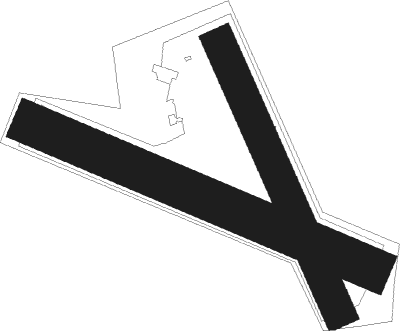
Runway info
Runway 16 / 34  | ||
| length | 892m (2927ft) | |
| bearing | 152° / 332° | |
| width | 99m (325ft) | |
| surface | grass | |
| displ threshold | 299m (981ft) / 0m (0ft) | |
| Runway 12 / 30 | ||
| length | 1118m (3668ft) | |
| bearing | 109° / 289° | |
| width | 127m (417ft) | |
| surface | grass | |
| displ threshold | 0m (0ft) / 218m (715ft) | |
Nearby beacons
| code | identifier | dist | bearing | frequency |
|---|---|---|---|---|
| VOZ | VOZICE VOR/DME | 10.6 | 50° | 116.95 |
| VLM | VLASIM VOR/DME | 23.4 | 49° | 114.30 |
| PSK | DME | 35.3 | 300° | 117.60 |
| OKF | DESNA VOR/DME | 41.5 | 117° | 113.15 |
| CF | CASLAV NDB | 41.7 | 55° | 345 |
| C | CASLAV NDB | 41.9 | 52° | 715 |
| F | CASLAV NDB | 42.3 | 49° | 715 |
| K | KBELY NDB | 44.6 | 349° | 438 |
| OKL | PRAGUE VOR/DME | 45.6 | 328° | 112.60 |
| KD | KBELY NDB | 45.8 | 355° | 300 |
| L | LIBOC (PRAGUE) NDB | 46.7 | 330° | 372 |
| V | MASLOVICE (VODOCHODY) NDB | 51.4 | 338° | 416 |
| NER | NERATOVICE VOR/DME | 58.6 | 355° | 112.25 |
| FRE | DME | 61.9 | 211° | 113.50 |
Disclaimer
The information on this website is not for real aviation. Use this data with the X-Plane flight simulator only! Data taken with kind consent from X-Plane 12 source code and data files. Content is subject to change without notice.