Vysoké Mýto - Vysoke Myto
Airport details
| Country | Czechia |
| State | Northeast |
| Region | LK |
| Airspace | Prague Ctr |
| Municipality | Vysoké Mýto |
| Elevation | 984ft (300m) |
| Timezone | GMT +1 |
| Coordinates | 49.92694, 16.18583 |
| Magnetic var | |
| Type | land |
| Available since | X-Plane v10.40 |
| ICAO code | LKVM |
| IATA code | n/a |
| FAA code | n/a |
Communication
| Vysoke Myto INFO | 130.605 |
Nearby Points of Interest:
Statue of Knířovská madona
-Dolní mlýn
-Mlýn Betlém
-Chapel of Saint Michael
-Bell tower in Zámrsk
-Church of Saint Martin
-Church of Saint Nicholas in Svatý Mikuláš
-křížová cesta
-Nové Hrady Castle
-Divadlo Smetanův dům
-Vyšší odborná škola pedagogická a Střední pedagogická škola, Litomyšl
-Litomyšl
-Regionální muzeum v Litomyšli
-Town hall in Litomyšl
-Chapel of saint Methodius (Litomyšl)
-Brandýs nad Orlicí Chateau
-Nová radnice
-Dům U Rytířů
-City walls of Litomyšl
-Maria column in Litomyšl
-Church of the Annunciation of the Virgin Mary (Doly)
-Synagogue in Luže
-Strážní domek Sudislav nad Orlicí čp. 51
-Church of Saint Wenceslaus in Lažany
-Town hall in Ústí nad Orlicí
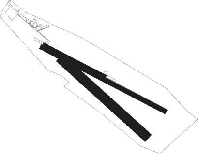
Runway info
Runway 12L / 30R  | ||
| length | 600m (1969ft) | |
| bearing | 112° / 292° | |
| width | 18m (59ft) | |
| surface | asphalt | |
| Runway 12R / 30L | ||
| length | 1198m (3930ft) | |
| bearing | 112° / 292° | |
| width | 40m (131ft) | |
| surface | grass | |
| Runway 14 / 32 | ||
| length | 968m (3176ft) | |
| bearing | 124° / 304° | |
| width | 80m (262ft) | |
| surface | grass | |
Nearby beacons
| code | identifier | dist | bearing | frequency |
|---|---|---|---|---|
| PK | PARDUBICE NDB | 15.2 | 283° | 432 |
| P | PARDUBICE NDB | 16.8 | 282° | 888 |
| CF | CASLAV NDB | 29.1 | 268° | 345 |
| C | CASLAV NDB | 30.2 | 270° | 715 |
| F | CASLAV NDB | 32.1 | 272° | 715 |
| XU | NAMEST NDB | 44 | 189° | 563 |
| X | NAMEST NDB | 44.9 | 187° | 362 |
| L | NAMEST NDB | 46.6 | 182° | 362 |
| LA | NAMEST NDB | 47.4 | 180° | 514 |
| BNO | BRNO VOR/DME | 50.6 | 147° | 114.45 |
| B | BOREK (BRNO) NDB | 51.2 | 145° | 429 |
| OKF | DESNA VOR/DME | 62.7 | 214° | 113.15 |
Disclaimer
The information on this website is not for real aviation. Use this data with the X-Plane flight simulator only! Data taken with kind consent from X-Plane 12 source code and data files. Content is subject to change without notice.