Yotvata
Airport details
| Country | Israel |
| State | South District |
| Region | |
| Airspace | Tel Aviv Ctr |
| Municipality | Hevel Eilot Regional Council |
| Elevation | 297ft (91m) |
| Timezone | GMT +2 |
| Coordinates | 29.90096, 35.06752 |
| Magnetic var | |
| Type | land |
| Available since | X-Plane v10.40 |
| ICAO code | LL63 |
| IATA code | YOT |
| FAA code | n/a |
Communication
Nearby Points of Interest:
Timna valley
-Umm Rashrash Police Station
-Wadi Rum
-Har Karkom
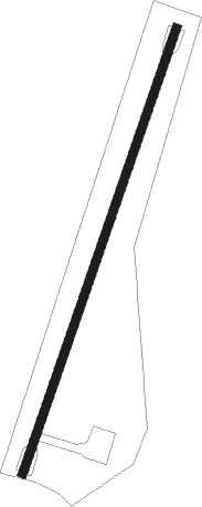
Runway info
| Runway 02 / 20 | ||
| length | 1011m (3317ft) | |
| bearing | 27° / 207° | |
| width | 18m (59ft) | |
| surface | asphalt | |
Nearby beacons
| code | identifier | dist | bearing | frequency |
|---|---|---|---|---|
| AQC | KING HUSSEIN NDB | 2.6 | 89° | 326 |
| RAM | EILAT VOR/DME | 9.2 | 198° | 113.85 |
| LOT | EILOT VOR/DME | 18.2 | 197° | 112 |
| AQB | AQABA VOR/DME | 19.3 | 191° | 113.10 |
| TBA | TABA VOR/DME | 22.5 | 223° | 114.50 |
| ZFR | ZOFAR VOR/DME | 39.8 | 8° | 115.60 |
| NWB | NUWEIBAA NDB | 56.1 | 205° | 288 |
Disclaimer
The information on this website is not for real aviation. Use this data with the X-Plane flight simulator only! Data taken with kind consent from X-Plane 12 source code and data files. Content is subject to change without notice.