Hatzor
Airport details
| Country | Israel |
| State | South District |
| Region | |
| Airspace | Tel Aviv Ctr |
| Municipality | Beer Tuvia Regional Council |
| Elevation | 146ft (45m) |
| Timezone | GMT +2 |
| Coordinates | 31.75472, 34.71820 |
| Magnetic var | |
| Type | land |
| Available since | X-Plane v10.40 |
| ICAO code | LLHS |
| IATA code | n/a |
| FAA code | n/a |
Communication
| Hatzor TEL AVIV Approach | 121.400 |
| Hatzor TEL AVIV Approach | 120.900 |
Nearby Points of Interest:
Turkish Railway Bridge Over Ela River
-The Arcs bridge over Lachish stream
-Sverdloff Hut
-Yeshurun Central Synagogue
-Gedera Museum
-Negba Open Air Museum
-Yesha House
-Givat Brenner Pigeon Coop
-Sereni House
-Beit Amidim
-Rehovot Yosefzon House
-Rehovot Assembly Hall
-Gvar'am Amphitheater
-Beit Govrin Police Station
-White mosque
-Bet HaTavshil
-Rishon LeZion old water tower
-London Hotel
-Freimann House
-The Security Road
-The Negev Water and Defence Museum
-Etzion grove
-Yitzhak Sadeh house
-Mikveh Israel
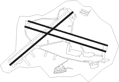
Runway info
Runway 11R / 29L  | ||
| length | 2475m (8120ft) | |
| bearing | 109° / 289° | |
| width | 46m (151ft) | |
| surface | asphalt | |
| blast zone | 140m (459ft) / 160m (525ft) | |
| Runway 11L / 29R | ||
| length | 2435m (7989ft) | |
| bearing | 109° / 289° | |
| width | 35m (115ft) | |
| surface | asphalt | |
| blast zone | 200m (656ft) / 155m (509ft) | |
| Runway 05 / 23 | ||
| length | 2411m (7910ft) | |
| bearing | 59° / 239° | |
| width | 46m (150ft) | |
| surface | asphalt | |
| blast zone | 152m (499ft) / 152m (499ft) | |
Nearby beacons
| code | identifier | dist | bearing | frequency |
|---|---|---|---|---|
| BGN | BEN GURION (TEL AVIV) VOR/DME | 17.4 | 31° | 113.50 |
| BSA | BEER SHEBA VOR/DME | 28.1 | 180° | 114.30 |
| NAT | NATANIA VOR/DME | 37 | 23° | 112.40 |
| MZD | METZADA VOR/DME | 42.8 | 122° | 115 |
| RMD | RAMAT DAVID NDB | 59.6 | 27° | 368 |
| ARH | EL ARISH VOR/DME | 61.1 | 232° | 113.60 |
Disclaimer
The information on this website is not for real aviation. Use this data with the X-Plane flight simulator only! Data taken with kind consent from X-Plane 12 source code and data files. Content is subject to change without notice.