Airports for X-Plane offers a convenient way to explore airports and their related communication information for the X-Plane flight simulator. It only uses data from the X-Plane flight simulator itself, and is therefore more reliable than the data that comes from real aviation websites. You can search for airports by using the ICAO code, or browse for airports per country and state. The information displayed is categorized by airport details, runway information, airport communication, approach frequencies (ILS and Glidepath details), details of nearby beacons, SIDs, STARs and approach procedures.

newark station international airport taxiway jetliner flown takeoff runway train military landing area airliner airport terminal airborne airdock capital consulate faa landing heliport

Feldkirchen - Feldkirchen/ossiacher See

Airport details

CountryAustria
StateCarinthia
RegionLO
AirspaceVienna Ctr
MunicipalityFeldkirchen in Kärnten
Elevation1706ft (520m)
TimezoneGMT +1
Coordinates46.71065, 14.07706
Magnetic var
Typeland
Available sinceX-Plane v10.40
ICAO codeLOKF
IATA coden/a
FAA coden/a

Communication

Feldkirchen/Ossiacher See Feldkirchen Flugplatz122.705
Nearby Points of Interest:
Filialkirche hl. Margareta, Tiffen (Steindorf am Ossiacher See)
-
Gschlosser, Tiffen
-
Kirche in Waiern
-
Pfarrkirche hl. Laurentius, Glanhofen, Feldkirchen
-
Schloss Greifenthurn
-
Filialkirche hl. Philipp und Jakob, Pichlern
-
Filialkirche hl. Leonhard, Stocklitz, Feldkirchen
-
Schloss Biberstein (Kärnten)
-
Filialkirche hl. Thomas, Himmelberg
-
Pfarrkirche hl. Radegundis, Radweg
-
Pfarrkirche hl. Martin in Himmelberg
-
Saint Andreas in Wachsenberg
-
Filialkirche hll. Philippus und Jakobus, Briefelsdorf
-
St. Andreas und Nikolaus (Knasweg)
-
Filialkirche Heiliger Antonius auf dem Tauern
-
Filialkirche Kleingradenegg
-
Schloss Tigring
-
Pfarrkirche hl. Urban, Sankt Urban
-
Leonhard-Kapelle (Benesirnitz)
-
Burgruine Steuerberg
-
Burgruine Glanegg
-
Evangelische Pfarrkirche Gnesau
-
Villa Miralago
-
Schloss Ratzenegg
-
Burgruine Alt-Albeck

Runway info

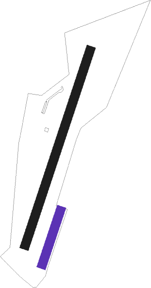
Runway 02 / 20  
 length689m (2260ft)
 bearing32° / 212°
 width30m (98ft)
 surfacegrass
Runway 02R / 20L
 length189m (620ft)
 bearing32° / 212°
 width30m (98ft)
 surfacegrass

Airport layout - runway 02R / 20L


Nearby beacons

codeidentifierdistbearingfrequency
VIWDME6.7265°112.90
KIKLAGENFURT NDB13.4104°313
KFTKLAGENFURT NDB19.5101°374
KFTKLAGENFURT VOR/DME21.1103°113.10
LBLLJUBLJANA VOR/DME31.8143°117.20
KORDME3785°109.40
MGLJUBLJANA NDB37.8138°296
ZWZELTWEG NDB40.354°418
DOLDOLSKO VOR/DME47.5132°112.70
RCHRONCHI DEI LEGIONARI VOR/DME58.4214°114.20
RIVRIVOLTO TACAN59.3234°110
RONRONCHI DEI LEGIONARI NDB60.7219°396

Disclaimer

The information on this website is not for real aviation. Use this data with the X-Plane flight simulator only! Data taken with kind consent from X-Plane 12 source code and data files. Content is subject to change without notice.