Airports for X-Plane offers a convenient way to explore airports and their related communication information for the X-Plane flight simulator. It only uses data from the X-Plane flight simulator itself, and is therefore more reliable than the data that comes from real aviation websites. You can search for airports by using the ICAO code, or browse for airports per country and state. The information displayed is categorized by airport details, runway information, airport communication, approach frequencies (ILS and Glidepath details), details of nearby beacons, SIDs, STARs and approach procedures.

airbus runway port air traffic control immigration airports passenger international airport jetliner train rail flights airbase aviation airport aircraft carrier customs station terminal luggage

Wels

Airport details

CountryAustria
StateUpper Austria
RegionLO
AirspaceVienna Ctr
MunicipalityWels
Elevation1041ft (317m)
TimezoneGMT +1
Coordinates48.17824, 14.03851
Magnetic var
Typeland
Available sinceX-Plane v10.40
ICAO codeLOLW
IATA coden/a
FAA coden/a

Communication

Wels Wels Flugplatz119.705
Nearby Points of Interest:
Jüdischer bzw. KZ-Friedhof
-
Stadtfriedhof Wels
-
Pfarrkirche Wels-Pernau
-
Pfarrkirche Wels-Heilige Familie
-
Dragonerkaserne Wels
-
Sankt Jakob
-
Sankt Vitus
-
Pfarrkirche Krenglbach
-
Pfarrkirche Mariä Himmelfahrt
-
Schloss Mistelbach
-
Schloss Steinhaus
-
Katholische Pfarrkirche Wallern an der Trattnach
-
Evangelische Pfarrkirche Wallern an der Trattnach
-
Sankt Georgen im Schauertal
-
Gunskirchen-Wels I concentration camp
-
Sankt Michael
-
Sankt Petrus
-
Pfarrkirche Hörsching
-
Sankt Leonhard
-
Benediktinerinnenkloster Steinerkirchen
-
Vogler Aerodrome
-
Schloss Schlüßlberg
-
Schloss Breitenau
-
Pfarr- und Wallfahrtskirche Maria Rast
-
Evang. Pfarrkirche A.B.

Runway info

Runway 08L / 26R  
 length1216m (3990ft)
 bearing89° / 269°
 width30m (98ft)
 surfaceasphalt
 displ threshold110m (361ft) / 0m (0ft)
 blast zone105m (344ft) / 76m (249ft)
Runway 08C / 26C
 length923m (3028ft)
 bearing89° / 269°
 width50m (164ft)
 surfacegrass
Runway 08R / 26L  
 length855m (2805ft)
 bearing89° / 269°
 width45m (148ft)
 surfacegrass
 displ threshold0m (0ft) / 99m (325ft)

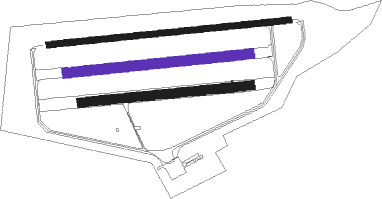
Airport layout - runway 08C / 26C


Taxiway locations
Parking locations

Nearby beacons

codeidentifierdistbearingfrequency
LNZLINZ VOR/DME451°116.60
LNZLINZ NDB11.878°327
FREDME15.620°113.50
GSBDME43.4248°109.45
ZWZELTWEG NDB65.6144°418

Disclaimer

The information on this website is not for real aviation. Use this data with the X-Plane flight simulator only! Data taken with kind consent from X-Plane 12 source code and data files. Content is subject to change without notice.