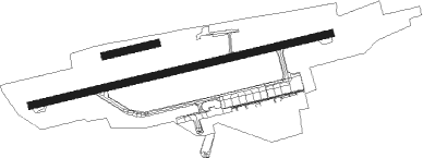
Innsbruck - Innsbruck Kranebitten
Airport details
| Country | Austria |
| State | Tyrol |
| Region | LO |
| Airspace | Vienna Ctr |
| Municipality | Innsbruck |
| Elevation | 1904ft (580m) |
| Timezone | GMT +1 |
| Coordinates | 47.25502, 11.34548 |
| Magnetic var | |
| Type | land |
| Available since | X-Plane v10.40 |
| ICAO code | LOWI |
| IATA code | INN |
| FAA code | n/a |
Communication
| Innsbruck Kranebitten Innsbruck ATIS | 126.025 |
| Innsbruck Kranebitten Innsbruck Tower | 120.100 |
| Innsbruck Kranebitten Innsbruck Approach | 119.275 |
Approach frequencies
| LOC | RW08 | 109.7 | 18.00mi |
| ILS-cat-I | RW26 | 111.1 | 18.00mi |
| 3.7° GS | RW26 | 111.1 | 18.00mi |
Nearby beacons
| code | identifier | dist | bearing | frequency |
|---|---|---|---|---|
| INN | INNSBRUCK NDB | 2.7 | 114° | 420 |
| RUM | RUM NDB | 5 | 80° | 320 |
| PAT | DME | 5.4 | 112° | 112 |
| RTT | RATTENBERG NDB | 26.4 | 74° | 303 |
| OBI | OBERPFAFFENHOFEN NDB | 49.6 | 356° | 429 |
| KPT | KEMPTEN VOR/DME | 50 | 296° | 108.40 |
| OZE | BOLZANO VOR/DME | 51 | 184° | 117.05 |
| OTT | OTTERSBERG VOR/DME | 58.7 | 27° | 112.30 |
| LCH | LECHFELD TACAN | 59.5 | 333° | 108.80 |
Departure and arrival routes
| Transition altitude | 11000ft |
| SID end points | distance | outbound heading | |
|---|---|---|---|
| RW08 | |||
| KOGO3J | 22mi | 8° | |
| UNKE2J | 61mi | 66° | |
| RTT3J, RTT2Q | 26mi | 74° | |
| OBED3J | 81mi | 88° | |
| BREN2J | 17mi | 174° | |
| ADIL2J | 17mi | 283° | |
| KPT5J | 50mi | 296° | |
| RW26 | |||
| RTT1R, RTT3X | 26mi | 74° | |
| MOGT1R, MOGT1X, MOGT3H | 27mi | 282° | |
| STAR starting points | distance | inbound heading | |
|---|---|---|---|
| ALL | |||
| ELME1A | 31.6 | 92° | |
| MADE1B | 43.2 | 94° | |
| XEBI1B | 36.2 | 100° | |
| TULS3A | 32.2 | 225° | |
| SBG3A | 75.9 | 245° | |
| RTT1B | 26.4 | 254° | |
| BREN3A, BREN4B | 16.5 | 354° | |
Instrument approach procedures
| runway | airway (heading) | route (dist, bearing) |
|---|---|---|
| RW08-Y | ELMEM (92°) | ELMEM 13000ft WI810 (4mi, 88°) 13000ft WI811 (5mi, 88°) 10600ft WI812 (2mi, 88°) 9600ft WI813 (5mi, 88°) 8300ft |
| RNAV | WI813 8300ft WI814 (3mi, 88°) 7100ft WI006 (2mi, 88°) 7100ft WI005 (8mi, 106°) WI103 (7mi, 84°) RTT (22mi, 72°) 9500ft RTT (turn) 9500ft | |
| RW08-Z | ELMEM (92°) | ELMEM 13000ft WI749 (3mi, 87°) 13000ft |
| RNAV | WI749 13000ft WI751 (17mi, 87°) WI752 (1mi, 97°) WI753 (7mi, 108°) WI754 (1mi, 96°) LOWI (3mi, 88°) 1957ft WI103 (4mi, 81°) WI002 (17mi, 74°) RTT (6mi, 65°) 9500ft RTT (turn) 9500ft | |
| RW26-E | WI610 (253°) | WI610 9500ft WI666 (1mi, 239°) 9000ft WI611 (4mi, 239°) 7200ft WI612 (2mi, 239°) 6300ft |
| RNAV | WI612 6300ft WI613 (2mi, 261°) 5750ft WI614 (9mi, 261°) 2275ft WI103 (3mi, 83°) WI612 (8mi, 80°) WI610 (8mi, 59°) RTT (7mi, 75°) 9500ft RTT (turn) 9500ft | |
| RW26-Z | RTT (254°) | RTT 9500ft WI002 (6mi, 245°) 9500ft |
| RNAV | WI002 9500ft WI103 (17mi, 254°) LOWI (4mi, 261°) 1944ft WI005 (3mi, 268°) WI006 (8mi, 286°) WI007 (4mi, 278°) WI008 (3mi, 172°) WI006 (4mi, 74°) WI005 (8mi, 106°) WI103 (7mi, 84°) WI002 (17mi, 74°) RTT (6mi, 65°) 11500ft RTT (turn) |
Holding patterns
| STAR name | hold at | type | turn | heading* | altitude | leg | speed limit |
|---|---|---|---|---|---|---|---|
| BREN3A | RTT | FIX | right | 45 (225)° | > 9500ft | 1.0min timed | ICAO rules |
| BREN4B | ELMEM | VHF | left | 328 (148)° | > 13000ft | 1.0min timed | ICAO rules |
| ELME1A | RTT | FIX | right | 45 (225)° | > 9500ft | 1.0min timed | ICAO rules |
| MADE1B | ELMEM | VHF | left | 328 (148)° | > 13000ft | 1.0min timed | ICAO rules |
| NANI2A | RTT | FIX | right | 45 (225)° | > 9500ft | 1.0min timed | ICAO rules |
| RTT1B | ELMEM | VHF | left | 328 (148)° | > 13000ft | 1.0min timed | ICAO rules |
| SBG3A | RTT | FIX | right | 45 (225)° | > 9500ft | 1.0min timed | ICAO rules |
| TULS3A | RTT | FIX | right | 45 (225)° | > 9500ft | 1.0min timed | ICAO rules |
| XEBI1B | ELMEM | VHF | left | 328 (148)° | > 13000ft | 1.0min timed | ICAO rules |
| *) magnetic outbound (inbound) holding course | |||||||
Disclaimer
The information on this website is not for real aviation. Use this data with the X-Plane flight simulator only! Data taken with kind consent from X-Plane 12 source code and data files. Content is subject to change without notice.

