Wiener Neustadt - Wr Neustadt West
Airport details
| Country | Austria |
| State | Lower Austria |
| Region | LO |
| Airspace | Vienna Ctr |
| Municipality | Wiener Neustadt |
| Elevation | 830ft (253m) |
| Timezone | GMT +1 |
| Coordinates | 47.83972, 16.22028 |
| Magnetic var | |
| Type | land |
| Available since | X-Plane v10.40 |
| ICAO code | LOXN |
| IATA code | n/a |
| FAA code | n/a |
Communication
| Wr Neustadt West Tower | 130.150 |
Nearby Points of Interest:
Fliegerkaserne Wiener Neustadt
-Dr.-Karl-Renner-Hof
-Israelitischer Friedhof Wiener Neustadt
-Maximilian-Kaserne
-Spinnerin am Kreuz (Wiener Neustadt)
-Landesberufsschule
-Wiener Neustädter Lokomotivfabrik
-Schule am Baumkirchnerring
-Schule Santa Christiana Wiener Neustadt
-Stadtarchiv Wiener Neustadt
-Dompropstei Wiener Neustadt
-Pestalozzischule Wiener Neustadt
-Rabenturm
-Karmeliterkirche
-Hauptplatz 20, Wiener Neustadt
-Lederergasse 8
-Kasematten Wiener Neustadt
-Capuchin Church, Wiener Neustadt
-Marienheim Wiener Neustadt
-Teile der Stadtbefestigung
-Stubenberger Turm
-Deutschordenskommende Wiener Neustadt
-Landesgericht Wiener Neustadt
-Neunkirchner Straße 36 (Wiener Neustadt)
-St. George's Cathedral, Wiener Neustadt
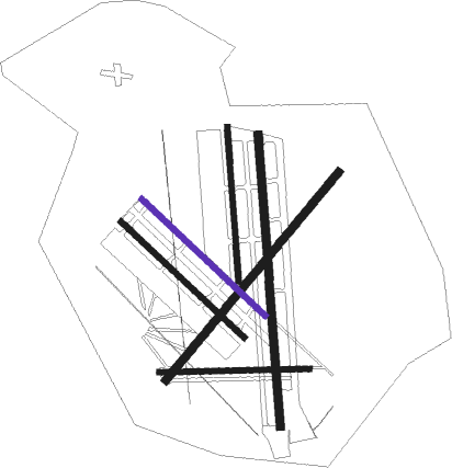
Runway info
Runway 09 / 27  | ||
| length | 838m (2749ft) | |
| bearing | 92° / 272° | |
| width | 30m (98ft) | |
| surface | grass | |
| Runway 04 / 22 | ||
| length | 1503m (4931ft) | |
| bearing | 55° / 235° | |
| width | 45m (148ft) | |
| surface | grass | |
| Runway 18L / 36R | ||
| length | 1626m (5335ft) | |
| bearing | 180° / 0° | |
| width | 45m (148ft) | |
| surface | grass | |
| Runway 18R / 36L | ||
| length | 864m (2835ft) | |
| bearing | 180° / 0° | |
| width | 30m (98ft) | |
| surface | grass | |
| Runway 14L / 32R | ||
| length | 942m (3091ft) | |
| bearing | 127° / 307° | |
| width | 30m (98ft) | |
| surface | grass | |
| Runway 14R / 32L | ||
| length | 941m (3087ft) | |
| bearing | 127° / 307° | |
| width | 30m (98ft) | |
| surface | grass | |
Nearby beacons
| code | identifier | dist | bearing | frequency |
|---|---|---|---|---|
| SNU | SOLLENAU VOR/DME | 3.4 | 63° | 115.50 |
| STE | STEINHOF NDB | 22.3 | 4° | 293 |
| FMD | FISCHAMEND VOR/DME | 22.9 | 57° | 110.40 |
| BRK | BRUCK NDB | 24 | 66° | 408 |
| TUN | TULLN NDB | 29.7 | 333° | 358 |
| TUN | TULLN VOR/DME | 29.8 | 333° | 111.40 |
| WGM | WAGRAM VOR/DME | 31 | 29° | 112.20 |
| STO | STOCKERAU VOR/DME | 35.6 | 341° | 113 |
| RAW | DME | 38 | 219° | 112.15 |
| GBG | GLEICHENBERG NDB | 59.7 | 204° | 426 |
| STK | KOGEL DME | 60.8 | 196° | 114.55 |
| GRZ | GRAZ VOR/DME | 61.6 | 221° | 116.20 |
| GRZ | GRAZ NDB | 63.2 | 220° | 290 |
Disclaimer
The information on this website is not for real aviation. Use this data with the X-Plane flight simulator only! Data taken with kind consent from X-Plane 12 source code and data files. Content is subject to change without notice.