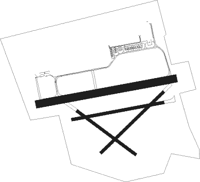
Langenlebarn - Tulln
Airport details
| Country | Austria |
| State | Lower Austria |
| Region | LO |
| Airspace | Vienna Ctr |
| Municipality | Gemeinde Tulln an der Donau |
| Elevation | 575ft (175m) |
| Timezone | GMT +1 |
| Coordinates | 48.32028, 16.11333 |
| Magnetic var | |
| Type | land |
| Available since | X-Plane v10.40 |
| ICAO code | LOXT |
| IATA code | n/a |
| FAA code | n/a |
Communication
| Tulln Tower | 118.900 |
| Tulln Approach | 136.125 |
Runway info
Nearby beacons
| code | identifier | dist | bearing | frequency |
|---|---|---|---|---|
| TUN | TULLN NDB | 5.3 | 265° | 358 |
| STO | STOCKERAU VOR/DME | 6.9 | 316° | 113 |
| STE | STEINHOF NDB | 8.4 | 129° | 293 |
| WGM | WAGRAM VOR/DME | 15 | 89° | 112.20 |
| FMD | FISCHAMEND VOR/DME | 24.3 | 113° | 110.40 |
| SNU | SOLLENAU VOR/DME | 27.6 | 159° | 115.50 |
| BRK | BRUCK NDB | 28.6 | 113° | 408 |
| OKF | DESNA VOR/DME | 45 | 319° | 113.15 |
| LA | NAMEST NDB | 49 | 5° | 514 |
| L | NAMEST NDB | 49.8 | 3° | 362 |
| X | NAMEST NDB | 51.6 | 359° | 362 |
| XU | NAMEST NDB | 52.7 | 357° | 563 |
| BNO | BRNO VOR/DME | 54.8 | 35° | 114.45 |
| B | BOREK (BRNO) NDB | 55.3 | 36° | 429 |
Instrument approach procedures
| runway | airway (heading) | route (dist, bearing) |
|---|---|---|
| RW08 | HOLXA (158°) | HOLXA 3000ft STO (5mi, 200°) 3000ft XT801 (9mi, 263°) 3000ft XT803 (6mi, 171°) 3000ft |
| RW08 | XT801 (103°) | XT801 3000ft XT803 (6mi, 171°) 3000ft |
| RW08 | XT802 (68°) | XT802 4000ft XT803 (6mi, 351°) 3000ft |
| RNAV | XT803 3000ft XT804 (5mi, 86°) 3000ft LOXT (7mi, 86°) 624ft XT805 (1mi, 88°) XT805 (turn) 2000ft HOLXA (11mi, 330°) 3000ft HOLXA (turn) 3000ft |
Disclaimer
The information on this website is not for real aviation. Use this data with the X-Plane flight simulator only! Data taken with kind consent from X-Plane 12 source code and data files. Content is subject to change without notice.

