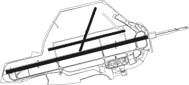
Zeltweg - Zeltweg Ab
Airport details
| Country | Austria |
| State | Styria |
| Region | LO |
| Airspace | Vienna Ctr |
| Municipality | Spielberg |
| Elevation | 2220ft (677m) |
| Timezone | GMT +1 |
| Coordinates | 47.20361, 14.74583 |
| Magnetic var | |
| Type | land |
| Available since | X-Plane v10.40 |
| ICAO code | LOXZ |
| IATA code | n/a |
| FAA code | n/a |
Communication
| Zeltweg AB Tower | 132.650 |
| Zeltweg AB Tower | 118.700 |
| Zeltweg AB RADAR | 129.475 |
| Zeltweg AB RADAR | 135.375 |
Runway info
Nearby beacons
| code | identifier | dist | bearing | frequency |
|---|---|---|---|---|
| ZW | ZELTWEG NDB | 0.5 | 120° | 418 |
| KOR | DME | 26.6 | 152° | 109.40 |
| GRZ | GRAZ VOR/DME | 32.4 | 109° | 116.20 |
| GRZ | GRAZ NDB | 33.7 | 112° | 290 |
| KFT | KLAGENFURT NDB | 35.8 | 200° | 374 |
| KFT | KLAGENFURT VOR/DME | 37.1 | 197° | 113.10 |
| KI | KLAGENFURT NDB | 37.3 | 213° | 313 |
| VIW | DME | 45.7 | 239° | 112.90 |
| MI | OREHOVA VAS (MARIBOR) NDB | 59.3 | 128° | 355 |
| LBL | LJUBLJANA VOR/DME | 59.4 | 198° | 117.20 |
Departure and arrival routes
| Transition altitude | 10000ft |
| SID end points | distance | outbound heading | |
|---|---|---|---|
| RW08R | |||
| GRZ1F | 32mi | 109° | |
| KFT1F | 36mi | 200° | |
| VILA1F | 46mi | 239° | |
| OBED1F | 58mi | 275° | |
| WIMI1F | 14mi | 329° | |
| LIMR1F | 44mi | 337° | |
| RW26L | |||
| MILG1D | 15mi | 74° | |
| GRZ1D | 32mi | 109° | |
| KFT1D | 36mi | 200° | |
| VILA1D | 46mi | 239° | |
| OBED1D | 58mi | 275° | |
| WIMI1D | 14mi | 329° | |
Instrument approach procedures
| runway | airway (heading) | route (dist, bearing) |
|---|---|---|
| RW26L | XZ821 (241°) | XZ821 8000ft XZ823 (5mi, 146°) 8000ft |
| RW26L | XZ822 (265°) | XZ822 8000ft XZ823 (5mi, 326°) 8000ft |
| RNAV | XZ823 8000ft XZ824 (5mi, 253°) 7000ft XZ825 (4mi, 253°) 5300ft XZ826 (3mi, 253°) 4000ft XZ827 (3mi, 253°) 2755ft XZ828 (3mi, 253°) XZ829 (15mi, 267°) 8000ft INLOX (16mi, 86°) 9000ft INLOX (turn) 9000ft |
Disclaimer
The information on this website is not for real aviation. Use this data with the X-Plane flight simulator only! Data taken with kind consent from X-Plane 12 source code and data files. Content is subject to change without notice.

